National Register of Historic Places listings in Comanche County, Oklahoma
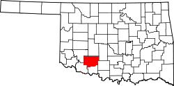
Location of Comanche County in Oklahoma
This is a list of the National Register of Historic Places listings in Comanche County, Oklahoma.
This is intended to be a complete list of the properties and districts on the National Register of Historic Places in Comanche County, Oklahoma, United States. The locations of National Register properties and districts for which the latitude and longitude coordinates are included below, may be seen in a map.[1]
There are 34 properties and districts listed on the National Register in the county, including 1 National Historic Landmark.
- This National Park Service list is complete through NPS recent listings posted October 11, 2018.[2]
Current listings
| [3] | Name on the Register[4] | Image | Date listed[5] | Location | City or town | Description |
|---|---|---|---|---|---|---|
| 1 | Arrastra Site | 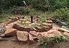 |
May 11, 1981 (#81000455) |
Cedar Plantation, Wichita Mountains Wildlife Refuge 34°45′10″N 98°34′34″W / 34.75276°N 98.57603°W |
Cache | Spanish-style arrastra from the 19th Century, located at a bend in Cedar Creek. |
| 2 | Balloon Hanger at Henry Post Army Airfield | 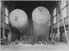 |
November 20, 2015 (#15000826) |
5037 Tucker Rd. 34°39′04″N 98°23′53″W / 34.651064°N 98.397928°W |
Fort Sill | |
| 3 | Mattie Beal House | 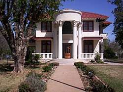 |
August 19, 1975 (#75001564) |
5th St. and Summit Ave. 34°35′44″N 98°23′41″W / 34.595556°N 98.394722°W |
Lawton | |
| 4 | Blockhouse on Signal Mountain | 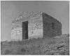 |
November 29, 1978 (#78002228) |
Off Mackenzie Hill Rd. 34°40′27″N 98°29′25″W / 34.674167°N 98.490278°W |
Fort Sill | An easily identifiable landmark at the peak of Signal Mountain on an active field artillery range. Renowned as "the Mecca for field artillery soldiers".[6] |
| 5 | Boulder Cabin | 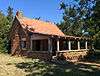 |
May 11, 1981 (#81000456) |
Northwest of Cache, Wichita Mountains Wildlife Refuge 34°42′06″N 98°40′30″W / 34.701667°N 98.675°W |
Cache | |
| 6 | Buffalo Lodge | May 11, 1981 (#81000457) |
Northwest of Cache 34°44′00″N 98°42′38″W / 34.733333°N 98.710556°W |
Cache | ||
| 7 | Building 309, Fort Sill Indian School |  |
October 15, 1973 (#73001559) |
Eastern edge of Lawton, off U.S. Route 62 34°37′23″N 98°22′51″W / 34.62312°N 98.38081°W |
Lawton | |
| 8 | Camp Comanche Site | May 12, 1977 (#77001091) |
Address Restricted |
Fort Sill | ||
| 9 | Carnegie Library | 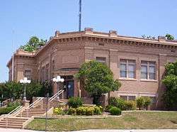 |
August 19, 1976 (#76001560) |
B Ave. and 5th St. 34°36′24″N 98°23′40″W / 34.606667°N 98.394444°W |
Lawton | |
| 10 | Central Fire Station | 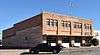 |
September 7, 2016 (#16000618) |
623 SW. D Ave. 34°36′15″N 98°23′53″W / 34.604055°N 98.398035°W |
Lawton | Still in use by the Lawton Fire Department. |
| 11 | Chiefs Knoll, Fort Sill Post Cemetery | 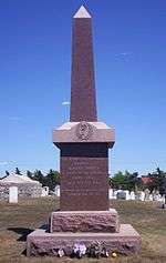 |
May 16, 1978 (#78002229) |
Macomb and Burrill Rds. 34°40′10″N 98°23′42″W / 34.669444°N 98.395°W |
Fort Sill | Final resting place of several indigenous chiefs of the Red River War, including Quanah Parker, Satanta, Satank, and Kicking Bird. |
| 12 | Comanche Indian Mission Cemetery | 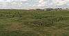 |
February 4, 2014 (#12000437) |
Henry Post Army Airfield, 4900 Area 34°38′32″N 98°23′33″W / 34.642318°N 98.392464°W |
Fort Sill | |
| 13 | Douglass School | 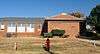 |
November 25, 2008 (#08001148) |
102 E. Gore Boulevard 34°36′35″N 98°23′08″W / 34.60977°N 98.38551°W |
Lawton | Closed in 2011 and currently used as a Professional Development Center by the school district.[7] |
| 14 | Federal Building and US Courthouse | 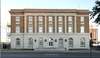 |
March 24, 2000 (#00000243) |
410 SW Fifth St.[8] 34°36′11″N 98°23′40″W / 34.603056°N 98.394444°W |
Lawton | |
| 15 | Ferguson House | 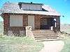 |
May 11, 1981 (#81000458) |
Northwest of Cache 34°43′00″N 98°36′20″W / 34.716667°N 98.605556°W |
Cache | Former residence located within the boundaries of the Wichita Mountains Wildlife Refuge. Vacant and open for many years, it has since been boarded up to deter trespassing. |
| 16 | First Christian Church |  |
March 12, 1985 (#85000566) |
701 D Ave. 34°36′16″N 98°23′54″W / 34.604444°N 98.398333°W |
Lawton | |
| 17 | First Presbyterian Church of Lawton | 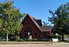 |
December 14, 1979 (#79001990) |
8th St. and D Ave. 34°36′13″N 98°23′58″W / 34.603611°N 98.399444°W |
Lawton | |
| 18 | First State Bank of Indiahoma | November 6, 1980 (#80003261) |
Main St. 34°37′10″N 98°45′06″W / 34.619444°N 98.751667°W |
Indiahoma | Building no longer exists. It was razed sometime around 1981. Banks fittings on display in the Museum of the Great Plains in Lawton. | |
| 19 | Fort Sill | 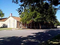 |
October 15, 1966 (#66000629) |
U.S. Route 62 34°40′13″N 98°23′15″W / 34.670278°N 98.3875°W |
Fort Sill | |
| 20 | General Officers Quarters | 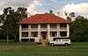 |
April 14, 1975 (#75001563) |
1310 Shanklin Circle 34°40′42″N 98°23′42″W / 34.678333°N 98.395°W |
Fort Sill | |
| 21 | Gore Pit District | November 21, 1980 (#80004520) |
Straddling Gore Boulevard east of central Lawton[9] 34°36′29″N 98°22′15″W / 34.608056°N 98.370833°W |
Lawton | ||
| 22 | Indian Cemeteries |  |
August 10, 1977 (#77001510) |
Fort Sill Military Reservation 34°42′06″N 98°22′09″W / 34.701667°N 98.369167°W |
Fort Sill | Includes the Beef Creek Apache Cemetery, final resting place of Geronimo. |
| 23 | Ingram House | 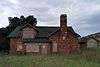 |
May 11, 1981 (#81000459) |
Northeast of Cache 34°43′22″N 98°36′09″W / 34.722778°N 98.6025°W |
Cache | |
| 24 | Lawton High School | 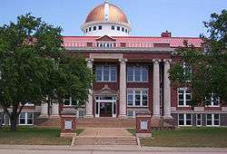 |
February 27, 1997 (#97000197) |
809 C Ave. 34°36′21″N 98°24′01″W / 34.605833°N 98.400278°W |
Lawton | Lawton High School is no longer at this location. Building now acts as city hall. |
| 25 | Lawton National Guard Armory | 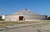 |
June 5, 2007 (#07000519) |
600 Northwest Cache Rd. 34°37′21″N 98°23′51″W / 34.6225°N 98.3975°W |
Lawton | |
| 26 | Mahoney-Clark House | 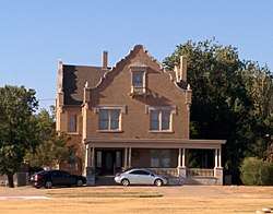 |
December 8, 1982 (#82001494) |
513-515 W. Gore Ave. 34°36′34″N 98°23′46″W / 34.609444°N 98.396111°W |
Lawton | |
| 27 | Medicine Bluffs | 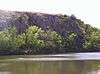 |
December 31, 1974 (#74001659) |
Medicine Bluff Creek 34°41′03″N 98°25′00″W / 34.684167°N 98.416667°W |
Fort Sill | Shouting "Geronimo" before a jump originates in a legend about the Apache warrior making an impossible jump from the bluffs. |
| 28 | Medicine Park Hotel and Annex | 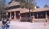 |
September 25, 1979 (#79001991) |
E. Lake Dr. 34°43′41″N 98°30′05″W / 34.728056°N 98.501389°W |
Medicine Park | Includes the historic Old Plantation restaurant. |
| 29 | Meers Mining Camp | 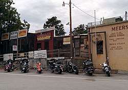 |
January 20, 1978 (#78002230) |
20 miles (32 km) northwest of Lawton 34°46′57″N 98°34′45″W / 34.7825°N 98.579167°W |
Lawton | Former mining town, reduced to a rural neighborhood outside the Wichita Mountains. The Meers Store & Restaurant is still open, and noted for its hamburgers. |
| 30 | Methodist Episcopal Church, South | 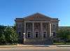 |
March 12, 1985 (#85000567) |
702 D Ave. 34°36′14″N 98°23′54″W / 34.603889°N 98.398333°W |
Lawton | |
| 31 | Old Tower Two | 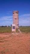 |
December 31, 1974 (#74001660) |
Northwest of Lawton at the junction of Signal Mountain and Tower Two Rds. 34°40′24″N 98°26′48″W / 34.673333°N 98.446667°W |
Fort Sill | Old observation tower used by Field Artillerymen on Fort Sill from 1911-1918. |
| 32 | Quanah Parker Star House | 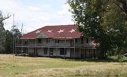 |
September 29, 1970 (#70000532) |
Eagle Park 34°37′42″N 98°38′34″W / 34.628333°N 98.642778°W |
Cache | Former home of Comanche Chief Quanah Parker. Moved from its original location, it now resides on the side of the long-closed Eagle Park, and is open only by appointment. |
| 33 | Penateka | 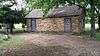 |
November 7, 1976 (#76001559) |
3.5 miles west of Elgin on U.S. Route 277 34°46′48″N 98°22′09″W / 34.78006°N 98.36917°W |
Elgin | |
| 34 | Henry Post Air Field | 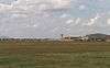 |
January 30, 1978 (#78002231) |
North of Lawton on Fort Sill 34°38′40″N 98°23′47″W / 34.644444°N 98.396389°W |
Fort Sill |
See also
| Wikimedia Commons has media related to National Register of Historic Places in Comanche County, Oklahoma. |
References
- ↑ The latitude and longitude information provided in this table was derived originally from the National Register Information System, which has been found to be fairly accurate for about 99% of listings. For about 1% of NRIS original coordinates, experience has shown that one or both coordinates are typos or otherwise extremely far off; some corrections may have been made. A more subtle problem causes many locations to be off by up to 150 yards, depending on location in the country: most NRIS coordinates were derived from tracing out latitude and longitudes from USGS topographical quadrant maps created under the North American Datum of 1927, which differs from the current, highly accurate WGS84 GPS system used by most on-line maps. Chicago is about right, but NRIS longitudes in Washington are higher by about 4.5 seconds, and are lower by about 2.0 seconds in Maine. Latitudes differ by about 1.0 second in Florida. Some locations in this table may have been corrected to current GPS standards.
- ↑ "National Register of Historic Places: Weekly List Actions". National Park Service, United States Department of the Interior. Retrieved on October 11, 2018.
- ↑ Numbers represent an ordering by significant words. Various colorings, defined here, differentiate National Historic Landmarks and historic districts from other NRHP buildings, structures, sites or objects.
- ↑ National Park Service (2009-03-13). "National Register Information System". National Register of Historic Places. National Park Service.
- ↑ The eight-digit number below each date is the number assigned to each location in the National Register Information System database, which can be viewed by clicking the number.
- ↑ "How to Conduct a Saint Barbara's Celebration". US Field Artillery Association: 26. Archived from the original on 21 December 2018. Retrieved 22 May 2018.
- ↑ "LPS to shut down Douglass, Howell Elementary schools". KSWO-TV. March 24, 2011. Archived from the original on November 19, 2016. Retrieved November 19, 2016.
- ↑ Lawton Federal Building and U.S. Courthouse. Accessed April 5, 2016.
- ↑ Hammatt, Hallett H. "The Gore Pit Site: An Archaeic Occupation in Southwestern Oklahoma and a Review of the Archaic Stage in the Southern Plains". Plains Anthropologist 21.74 (1976): 245-277: 246.
| Cache |
| |
|---|---|---|
| Elgin |
| |
| Fort Sill |
| |
| Indiahoma |
| |
| Lawton |
| |
| Medicine Park |
| |
| Meers | ||
| Topics | |
|---|---|
| Lists by states |
|
| Lists by insular areas | |
| Lists by associated states | |
| Other areas | |
| |
Municipalities and communities of Comanche County, Oklahoma, United States | ||
|---|---|---|
| Cities | | |
| Towns | ||
| Unincorporated communities | ||
| Footnotes | ‡This populated place also has portions in an adjacent county or counties | |
This article is issued from
Wikipedia.
The text is licensed under Creative Commons - Attribution - Sharealike.
Additional terms may apply for the media files.