Fort Nuestra Senora de la Soledad
|
Fort Nuestra Senora de la Soledad | |
 | |
 Fort Nuestra Senora de la Soledad | |
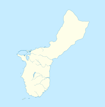
| Nearest city | Umatac, Guam |
|---|---|
| Coordinates | 13°17′36″N 144°39′27″E / 13.29333°N 144.65750°ECoordinates: 13°17′36″N 144°39′27″E / 13.29333°N 144.65750°E |
| Area | 8 acres (3.2 ha) |
| Built | c.1802-1819 |
| NRHP reference # | 74002042[1] |
| Added to NRHP | October 18, 1974 |
Fort Nuestra Senora de la Soledad (Spanish:Fuerte de Nuestra Señora de la Soledad) is a fortification near Umatac, Guam. Built by the Spanish probably between 1802 and 1819, it was the fourth of four fortifications that protected an anchorage for galleons transiting between Acapulco, Mexico and the Philippines, a route that fell out of use in 1815 with Mexican independence.
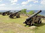
The fort has been damaged by treasure-hunters; it was made into a park following World War II. It was listed on the National Register of Historic Places in 1974.[1][2]
References
- 1 2 National Park Service (2010-07-09). "National Register Information System". National Register of Historic Places. National Park Service.
- ↑ David T. Lotz (January 8, 1974). "National Register of Historic Places Inventory/Nomination: Fort Nuestra Senora de la Soledad". National Park Service. and accompanying photos
External links

| Topics | |
|---|---|
| Lists by states |
|
| Lists by insular areas | |
| Lists by associated states | |
| Other areas | |
| |
This article is issued from
Wikipedia.
The text is licensed under Creative Commons - Attribution - Sharealike.
Additional terms may apply for the media files.