Dededo
| Dededo Dedidu | |
|---|---|
| City | |
 Location of Dededo within the Territory of Guam. | |
| Country | United States |
| Territory | Guam |
| Government | |
| • Mayor | Melissa B. Savares (D) |
| • Vice mayor | Frank A. "Daigo” Benavente (R) |
| Area | |
| • Total | 30 sq mi (80 km2) |
| Population (2010[1]) | |
| • Total | 44,943 |
| • Density | 1,498.1/sq mi (578.4/km2) |
| Time zone | UTC+10 (ChST) |
| Village Flower | Gardenia jasminoides |
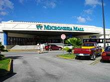
Dededo (Chamorro: Dedidu) is the most populated village[2] in the United States territory of Guam. According to the U.S. Census Bureau, Dededo's population was just under 45,000 in 2010. The village is located on the coral plateau of Northern Guam.
Etymology
The origin of the village name Dededo, Dedidu in Chamorro, may come from the practice of measuring using fingers. The Spanish word for finger is dedo. It can be theorized that someone measured out the original village this way. Another possibility is that the word “dededo” is a version of the word “dedeggo,” which means “heel of the foot,” or that it comes from the word “deggo” which means to “walk on tiptoes.”[3]
History
| Historical population | |||
|---|---|---|---|
| Census | Pop. | %± | |
| 1960 | 5,126 | — | |
| 1970 | 10,780 | 110.3% | |
| 1980 | 23,644 | 119.3% | |
| 1990 | 31,728 | 34.2% | |
| 2000 | 42,980 | 35.5% | |
| 2010 | 44,943 | 4.6% | |
| Source:[1] | |||
Before World War II, Dededo Village was at the bottom of Macheche Hill. Dededo grew into a major village after the war when the U.S. Navy constructed housing for displaced Guamanians and for laborers coming from off-island to help in Guam's development.
Following Typhoon Karen in 1962, Kaiser Subdivision in Dededo was constructed for islanders displaced by the storm. Further housing subdivisions were constructed increasing the village's population.
Geography
Dededo is located at the north central part of the island roughly at the center of population. It encompasses an area of about 30 square miles (78 km2) of Guam’s 209 square miles (540 km2). The headquarters for the Guam National Wildlife Refuge are in Dededo.[4]
Climate
| Climate data for Dededo, Guam | |||||||||||||
|---|---|---|---|---|---|---|---|---|---|---|---|---|---|
| Month | Jan | Feb | Mar | Apr | May | Jun | Jul | Aug | Sep | Oct | Nov | Dec | Year |
| Average high °F (°C) | 82 (28) |
82 (28) |
84 (29) |
86 (30) |
86 (30) |
86 (30) |
86 (30) |
86 (30) |
86 (30) |
86 (30) |
84 (29) |
84 (29) |
85 (29) |
| Average low °F (°C) | 69 (21) |
69 (21) |
71 (22) |
71 (22) |
73 (23) |
71 (22) |
71 (22) |
71 (22) |
71 (22) |
71 (22) |
73 (23) |
71 (22) |
71 (22) |
| Average precipitation inches (mm) | 5.7 (145) |
4.8 (122) |
3.8 (97) |
4.0 (102) |
5.2 (132) |
6.4 (163) |
11.1 (282) |
15.3 (389) |
14.3 (363) |
13.0 (330) |
9.4 (239) |
6.5 (165) |
99.6 (2,530) |
| Source: Weatherbase[5] | |||||||||||||
Education
Primary and secondary schools
Public schools
Dededo has several public and private schools to accommodate the growing number of residents of the island’s most populous village including Guam Department of Education institutions:
Elementary Schools
The village is served by 5 elementary schools:
- Astumbo Elementary School (Opened in 1997)
- Finegayan Elementary School (Opened in 1972)
- Juan M. Guerrero Elementary School (Opened in 1971)
- Maria A. Ulloa Elementary School (Opened in 1965)
- Wettengel Elementary School (Opened in 1968)
- Liguan Elementary School (Opened in 2008)

Middle Schools
The village has 2 middle schools:
- Vicente S.A. Benavente Middle School (Opened in 1966)
- Originally known as Dededo Middle School or Dededo Junior High; became VSA Benavente Middle School in 1999.
- Astumbo Middle School (Opened in 2008)

High Schools
The village is served by one high school:
- Okkodo High School (Opened in 2008)

The village also has one Archdiocese of Guam school: Santa Barbara Catholic School and two private Christian schools: St. Paul’s Christian School and Pacific Christian Academy.
Notable Residents
- Senator Dennis G. Rodriguez, Jr.
- Senator Michael San Nicolas
- Stephen J. Guerrero - Board chairman of Coast 360
- Jesseca Valencia - Former Guam Superintendent of Education
Village Mayors/Commissioners
Mayors/Commissioners
- Melissa B. Savares, Mayor, 2005–Present
- Scott D. Duenas, Mayor, 2001-2005
- Jose A. Rivera, Commissioner/Mayor, 1989-2001
- Patricia S. Quinata, Commissioner, 1985-1989
- Martin C. Benavente, Commissioner, 1981-1985
- Jose M. Garrido, Commissioner, 1977-1981
- Prospero C. Zamora, Commissioner, 1976-1977
- Vicente S.A. Benavente, Commissioner, 1952-1976
- Ramon S. San Agustin, Commissioner, 1944-1951
- Hector Sgambelluri, Commissioner, 1941-1944
- Juan Pangelinan, Commissioner, 1940-1941
- Ignacio A. Santos, Commissioner, 1934-1940
- Jose F. Lujan, Commissioner, 1932-1934
Vice Mayor/Assistant Commissioners
- Frank Benavente, Vice Mayor, 2017–Present
- Andrew A. Benavente, Vice Mayor, 2005-2016
- Melissa B. Savares, Vice Mayor, 2001-2005
- Doris S. Palacios, Assistant Commissioner/Vice Mayor, 1989-2001
- Patricia S. Quinata, Assistant Commissioner, 1981-1985
- Martin C. Benavente, Assistant Commissioner, 1978-1981
- Erwin F. Flauta, Assistant Commissioner, 1977-1978
- Prospero C. Zamora, Assistant Commissioner, 1973-1976
- Teresita B. Umagat, Assistant Commissioner, 1971-1974
- Manuel M. Lujan, Assistant Commissioner, 1934-1941
- Ignacio A. Santos, Assistant Commissioner, 1918-1934
Gallery
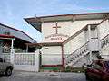 Santa Barbara School
Sources
- Rogers, Robert F (1995). Destiny's Landfall: A History of Guam. University of Hawai'i Press. ISBN 0-8248-1678-1
Notes
- 1 2 "2010 Guam Statistical Yearbook" (PDF). Archived from the original (PDF) on 2014-07-23. (4.3 MB), (rev. 2011)
- ↑ Therese Hart, "Guam Population slightly up, latest census says," Marianas Variety, August 26, 2011.
- ↑ "» Dededo (Dededu)". www.guampedia.com.
- ↑ "Welcome to Guam National Wildlife Refuge". US Fish and Wildlife Service. 2010-05-03. Retrieved 2012-02-21.
- ↑ "Weatherbase: Historical Weather for Dededo, Guam". Weatherbase. 2011. Retrieved on November 24, 2011.
External links
| Wikimedia Commons has media related to Dededo, Guam. |
- Guampedia, Guam's Online Encyclopedia Dededo Village
- Dededo Guam at Guam Portal
Hagåtña (capital) | |
| Topics | |
| Islands | |
| Villages | |
| Peaks |
|
Coordinates: 13°30′55″N 144°50′10″E / 13.51528°N 144.83611°E