Agat, Guam
| Agat Hagat | |
|---|---|
| Village | |
 Location of Agat within the Territory of Guam. | |
| Country | United States |
| Territory | Guam |
| Government | |
| • Mayor | Kevin J.T. Susuico (R) |
| • Vice mayor | Christopher J. Fejeran (R) |
| Population (2010)[1] | |
| • Total | 4,917 |
| • Ethnic groups | (as of 2,000[2]) 57.8% Chamorro, 23.4% Filipino, 11.6% two or more races |
| Time zone | UTC+10 (ChST) |
| Village Flower | Yellow gumamela |
Agat (Chamorro: Hagat) is a village in the United States territory of Guam. It is located south of Apra Harbor on the island's western shore. The village's population has decreased since the island's 2000 census.[3]
The village is 10 miles (16 km) southwest of Hagåtña,[4] with most of the residents ethnic Chamorros, the indigenous people of Guam. Some of Agat's most notable sites are Mount Alifan, the Agat Marina, the Spanish Bridge, and War In The Pacific National Historical Park.
History
| Historical population | |||
|---|---|---|---|
| Census | Pop. | %± | |
| 1960 | 3,107 | — | |
| 1970 | 4,308 | 38.7% | |
| 1980 | 3,999 | −7.2% | |
| 1990 | 4,960 | 24.0% | |
| 2000 | 5,656 | 14.0% | |
| 2010 | 4,917 | −13.1% | |
| Source:[1] | |||
In 1565, the Spanish explorer Miguel López de Legazpi claimed Guam for Spain. Agat was founded between 1680 and 1684, by the Spanish Governor Don Jose Quiroga, as a military garrison for the purpose of controlling the Chamorro people and converting them to Christianity. Many of its first citizens were brought from the internal village of Fina which was destroyed while the Spanish pacified the island. It was one of six such settlements on Guam in the 18th century. During the 1830s, the Spanish Governor, Captain Villalobos, began constructing facilities in Agat planning to make it the island's new capital. Lack of funds prevented him from completing the project.
In 1898, Guam was transferred from Spain to the United States following the Spanish–American War. Under U.S. Naval administration, Agat was incorporated as a township with an American style municipal government.
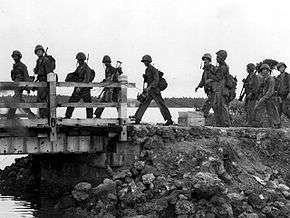
During World War II, Japan occupied Guam from 1941 to 1944. During the Battle of Guam in 1944, Agat was one of the two landing sites for U.S. Marines. These sites are now part of the War in the Pacific National Historical Park. The old village was destroyed during the invasion. After capturing Guam, the U.S. military constructed a new residential community in Agat for Guam residents made homeless by the war south of the original village.
Education
Primary and secondary schools
Public schools
Guam Public School System serves the island.
Marcial Sablan Elementary School and Oceanview Middle School are located in Agat. Southern High School in Santa Rita serves the village.[5]
Oceanview Middle School was originally Oceanview High School; the campus became a middle school in 1997.[6]
Private schools
Our Lady of Mount Carmel Catholic School is located in Agat and accommodates students in pre-kindergarten through eighth grade.[7]
Public libraries
Guam Public Library System operates the Agat Library at 165 Follard Street.[8]
Mayor of Agat
Commissioner
- Antonio P. Carbullido (1930–1934) (1st Term)
- Tomas C. Charfauros (1934–1937)
- Francisco R. Chaco (1937–1940)
- Francisco C. Sablan (1941–1944)
- Antonio P. Carbullido (1945–1956) (2nd Term)
- Juan L.G. Leon Guerrero (1956–1963)
- Jose B. Guevara (1963–1965)
- Thomas F.P. Muña (1965–1969)
Mayor
- Jose S. San Nicolas (1973–1977)
- Antonio R. Terlaje (1977–1981)
- Antonio C. Babauta (1981–1996)
- Joaquin G. Topasna (1996–1997)
- Johnny M. Reyes (1997–2005)
- Carol S. Tayama (2005–2017)
- Kevin J.T. Susuico (2017–present)
Deputy Commissioner
- Jose Pereda (1898–1903)
- Jesus Carbullido (1903–1908)
- Pedro C. Charfauros (1931–1933)
- Vicente M. Salas (1934–1937)
- Jose S. San Nicolas (1970–1973)
Vice Mayor
- Vicente Q. Guerrero (1973–1977)
- Antonio C. Babauta (1977–1981)
- Jose R. Reyes (1981–1989)
- John A. Quidachay (1989–1993)
- Joaquin G. Topasna (1993–1996)
- Jessie S. Pendon (1996–1997)
- Jesus B. Chaco (1997–2009) (Died in office)
- Agustin G. Quintanilla (2009–2015) (Died in Office)
- Kevin J.T. Susuico (2015–2017)
- Christopher J. Fejeran (2017–present)
See also
References
- 1 2 "2010 Guam Statistical Yearbook" (PDF). Archived from the original (PDF) on 2014-07-23. (4.3 MB), (rev. 2011)
- ↑ 2000 Census of Population and Housing: Guam, (rev. May 2004) p. 14
- ↑ Therese Hart, "Guam Population slightly up, latest census says," Marianas Variety, August 26, 2011, http://mvguam.com/index.php?option=com_content&view=article&id=19623:guam-population-slightly-up-latest-census-says&catid=59:frontpagenews Archived 2016-01-26 at the Wayback Machine.
- ↑ "Area Maps - Agat." Pacific Daily News. Retrieved on October 11, 2010.
- ↑ "Guam's Public High Schools." Guam Public School System. Accessed September 8, 2008.
- ↑ http://www.gdoe.net/rpe/annual_grad_ratesSY96_02.htm
- ↑ Our Lady of Mount Carmel Catholic School – Guam
- ↑ http://gpls.guam.gov/Portals/50/GPLS_LOC/GPLS_Location_2007Apr12.xml%5Bpermanent+dead+link%5D
Further reading
- Rogers, Robert F (1995). Destiny's Landfall: A History of Guam: University of Hawai'i Press. ISBN 0-8248-1678-1
- Sanchez, Pedro C. Guahan, Guam: The History of our Island: Sanchez Publishing House.
Coordinates: 13°22′53″N 144°39′17″E / 13.38139°N 144.65472°E
Hagåtña (capital) | |
| Topics | |
| Islands | |
| Villages | |
| Peaks |
|