Agana Heights
| Agana Heights Tutuhan | |
|---|---|
| Village | |
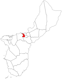 Location of Agana Heights within the Territory of Guam. | |
| Country | United States |
| Territory | Guam |
| Government | |
| • Mayor | Paul M. McDonald (R) |
| Population (2010[1]) | |
| • Total | 3,808 |
| Time zone | UTC+10 (ChST) |
| Village Flower |
Bougainvillea spectabilis Puti Tai Nobio |
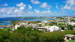
Agana Heights (Chamorro: Tutuhan) is one of the nineteen villages in the United States territory of Guam. It is located in the hills south of Hagåtña (formerly Agana), in the central part of the island. The United States Naval Hospital is located in this largely residential village.
| Historical population | |||
|---|---|---|---|
| Census | Pop. | %± | |
| 1960 | 3,210 | — | |
| 1970 | 3,156 | −1.7% | |
| 1980 | 3,284 | 4.1% | |
| 1990 | 3,646 | 11.0% | |
| 2000 | 3,940 | 8.1% | |
| 2010 | 3,808 | −3.4% | |
| Source:[1] | |||
Education
The village is served by the Guam Public School System Agana Heights Elementary School is in Agana Heights. Jose Rios Middle School in Piti serves sections of Agana Heights south of Tutujan Drive.[2] George Washington High School in Mangilao serves the village.[3] In addition, Department of Defense Education Activity operates Guam High School in Agana Heights. The Guam Adventist Academy was located in the village until it moved into its current Yona campus, which the institution secured in 1963.[4]
Notable residents
- Former Senator Joseph George Bamba - newcomer of CCU Vice-Chair and former Chief of Staff to Gov. Paul McDonald Calvo and Felix Camacho.
- Earl Joseph Garrido - Retired GPA member
- Carl Gutierrez – former Governor of Guam (1995–2003)[5]
- Geri Gutierrez - former First Lady of Guam (1995–2003)[5]
- Senator Rory J. Respicio - Former Democratic Party of Guam Chairman
Mayor of Agana Heights
Commissioner
- Beldad S. Santos (1944–1946)
- Anselmo Garrido (1946–1953)
- Juan L. Pangelinan (1956–1969)
- Juan E. Garcia (1969–1973)
Mayor
- Juan E. Garcia (1973–1977)
- Joaquin Chargualaf (1977–1981)
- Frank M. Portusach (1981–1993)
- Paul M. McDonald (1993–present)
See also
References
| Wikimedia Commons has media related to Agana Heights, Guam. |
- 1 2 "2010 Guam Statistical Yearbook" (PDF). Archived from the original (PDF) on 2014-07-23. (4.3 MB), (rev. 2011)
- ↑ https://web.archive.org/web/20060222192437/http://www.lk4kids.com/school%2Blinks.htm
- ↑ "Guam's Public High Schools." Guam Public School System. Accessed September 8, 2008.
- ↑ "About Us Archived 2011-07-26 at the Wayback Machine.." Guam Adventist Academy. Retrieved on October 10, 2010.
- 1 2 Sablan, Jerick (2014-07-10). "Former Guam Governor Officially Enters Gubernatorial Race". Pacific Daily News. East–West Center. Retrieved 2014-11-02.
Hagåtña (capital) | |
| Topics | |
| Islands | |
| Villages | |
| Peaks |
|
Coordinates: 13°28′06″N 144°44′45″E / 13.46833°N 144.74583°E