Nashirabad
| Nashirabad नशिराबाद | |
|---|---|
| Town | |
| Nickname(s): Solnimbhore | |
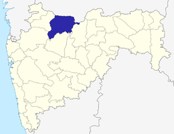
 Nashirabad Location in Maharashtra, India | |
| Coordinates: 21°00′00″N 75°40′00″E / 21.00000°N 75.66667°ECoordinates: 21°00′00″N 75°40′00″E / 21.00000°N 75.66667°E | |
| Country |
|
| State | Maharashtra |
| District | Jalgaon |
| Elevation | 206 m (676 ft) |
| Population | |
| • Total | 26,131(2,011) |
| Languages | |
| • Official | Marathi |
| Time zone | UTC+5:30 (IST) |
| PIN | 425309 |
| [1] | |
Nashirabad is a small town in Jalgaon district in the northern Maharashtra state in India. It was named after Nasiruddin Badshah. The earlier name of the town was Solnimbhore. This was due to fact that the town had 16 Hanuman temples and 16 main doors.
Demographics and economy
The population includes Brahmins, Leva Patil, Mali, and Teli, who run many businesses. The main business is the farming of banana trees and sugar cane.
Nashirabad is on National Highway No. 6 (Surat-Kolkata National Highway) and has many warehouses of local products.[2]
Transport
Most people depend on public transport (MSRTC), commonly known as "ST", and private hire vehicles like auto-rickshaw for commuting to and from district and taluka places like Jalgaon and Bhusawal. All the MSRTC buses except express bus services stop at Nashirabad bus stand. The nearest bus depots are at Jalgaon and Bhusawal.
Nearest railway stations are:
- Bhadli 2.5 km (halt for passenger trains only)
- Jalgaon 10 km (express and passenger halt)
- Bhusawal 16 km (all trains halt)
Religion
Temples
- Shri Vishnu Mandir Devasthan was established in 1725. This temple had been situated at Nashirabad since the time of Pesheve. Shri Vishnu Mandir Devasthan was built as per direction of Honorary Magistrate Kai. Amrutrao Deshpande.
- Shri. Ganpati Mandir Mandir, Indira Chowk,
- Vitthal Mandir - at Down Lane, Holi Maidan
- Balabhim Vyayamshala
- Anna Maharaj Math
- Sawata Maharaj Manidr - Upper Lane
- Ram Mandir
- Bavani Mandir
- Mukteshwar Mandir
- Mahalakshmi Mandir
- Ganpati Mandir (Tarsod 2.5 km from village)
- Neemjay Mata Bhavani's Mandir
- Dnyaneshwar maharaj mandir.
- Shree Krishna Mandir
- Ram Peth
- Ganpati Mandir (Nashirabad)
- Indira Gandhi Chowk
- Marimata Mandir (Ravindra Bhagvan Javre)
- Anna maharaj Mandir, near Grampanchayat
- Mahalaxmi Mandir
- Mhasoba dev sthan
Mosques
- Jaama Masjid - Emam Ahmad Raza road
- Sunni Kaali Masjid - Choupal Mohalla
- Mirzaani Masjid - Haidar Ali Mohalla
- Peer Shahabuddin Masjid - Emam Ahmad Raza road
- Momin Masjid -Momin mohalla upras
- Momin Masjid - Rehmatpura
- Manyar Mohalla Masjid - Manyar Mohalla
- Khwaja Masjid - Khwaja Garib Nawaz Nagar
- Khatoon-e-Jannat Masjid - Taaj Nagar
Areas
- Varchi Aali (Upper Lane) Varchi Ali Area - Most people of Mali, Mahajan and Maratha Samaj. The oldest temples of Shree Sant Sawatha Mali Maharaj and Shri Datta Mandir are attractive temples in the area. The area is divided as Patil wada, Naik Vada, Mahajan Wada, Ganpat Dula Wada, Varcha Wada, Mari Mata Wada and Sant Sawatha Mali Nagar.
- Khalchi Aali (Down Lane) - The area includes chaudhari wada, bajar patta, holi maiden, and dabepur wada.
References
- ↑ Pin codes of Jalgaon district, Jalgaon pincodes, Maharashtra zip code. WhereInCity. Retrieved on 2008-06-14.
- ↑ "Census of India 2001: Data from the 2001 Census, including cities, villages and towns (Provisional)". Census Commission of India. Archived from the original on 2004-06-16. Retrieved 2008-11-01.
