Karjod
| Karjod | |
|---|---|
| village | |
 Karjod Location in Maharashtra, India  Karjod Karjod (India) | |
| Coordinates: 21°16′16″N 76°5′8″E / 21.27111°N 76.08556°ECoordinates: 21°16′16″N 76°5′8″E / 21.27111°N 76.08556°E | |
| Country |
|
| State | Maharashtra |
| District | Jalgaon |
| Government | |
| • Body | Gram Panchayat |
| Languages | |
| • Official | Marathi |
| Time zone | UTC+5:30 (IST) |
Karjod (कर्जोद) is a small village on the foothills of the Satpura Range, in the administrative tehsil of Raver in Jalgaon district. It has a population of nearly 3000+.
Its nearest railway station is Waghod and nearest airport is Jalgaon.
Jalgaon district topics | ||
|---|---|---|
| History | 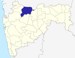 | |
| Tehsils | ||
| Lok Sabha constituencies | ||
| Vidhan Sabha constituencies | ||
| Towns and villages |
| |
| Places of interest | ||
This article is issued from
Wikipedia.
The text is licensed under Creative Commons - Attribution - Sharealike.
Additional terms may apply for the media files.