North Carolina Highway 11
| ||||
|---|---|---|---|---|
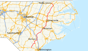 Route of NC 11 highlighted in red | ||||
| Route information | ||||
| Maintained by NCDOT | ||||
| Length | 193.2 mi (310.9 km) | |||
| Existed | 1921 – present | |||
| Major junctions | ||||
| South end |
| |||
| North end |
| |||
| Location | ||||
| Counties | Columbus, Bladen, Pender, Duplin, Lenoir, Pitt, Edgecombe, Martin, Bertie, Hertford | |||
| Highway system | ||||
| ||||

North Carolina Highway 11 (NC 11) is a primary state highway in the U.S. state of North Carolina. Traveling 193.2 miles (310.9 km), in a north–south alignment through Eastern North Carolina, it connects the towns and cities of Wallace, Kenansville, Kinston, Greenville and Murfreesboro.
Route description
NC 11 begins at US 74/US 76, in the unincorporated community of Freeman, where it travels north to NC 87, at Sandyfield, before exiting Columbus County.[1] Soon entering Bladen County, it crosses the Cape Fear River, then travels nearly seven miles (11 km) to Long View, where it joins with NC 53 before crossing the Black River and into Pender County.[2] Traveling in a northeasterly direction, NC 11/NC 53 turns east at Atkinson; at Wards Corner it changes concurrency from NC 53, which continues to Burgaw, to US 421 towards Clinton. After over seven miles (11 km), NC 11 splits from US 421 and continues northeast through Penderlea and Willard, where it then joins US 117 near I-40 (exit 390). Traveling northeast, it crosses over Rock Fish Creek into Duplin County.[3]
NC 11 splits towards the Tin City area of Wallace, while US 117 continues towards the downtown area. Northeast of Wallace, NC 11 connects with I-40 (exit 385) and continues through Murphey, Greenevers and Register before reaching the NC 24/NC 903 Kenansville Bypass (which can be used as a valid bypass despite not signed for NC 11). Continuing through Kenansville, it joins briefly with NC 50; north of town, it joins with NC 903 and continues northeast to Kornegay, where it switches concurrency with NC 111 for 0.3 miles (0.48 km) before continuing east into Lenoir County.[4] At Pink Hill, NC 11 continues northeasterly and widens to a four-lane divided highway as it travels through Deep Run and Albrittons and Jacksons Crossroads, where it is joined by NC 55. At an area known as Skinner's By-Pass, NC 11/NC 55 enter Kinston's city limits and connects with US 70/US 258. Crossing east over the Neuse River and into downtown Kinston, NC 11/NC 55 connect with US 70 Business/US 258 Business along Queen Street. At a roundabout, NC 11/NC 55 returns to a northeasterly direction and through the Harverytown area of Kinston. Upon leaving Kinston's city limits, NC 55 splits and continues towards New Bern. Parallel to the CSX rail line, since Graingers, NC 11 connects with NC 118, which connects to nearby Grifton, before crossing the Contentnea Creek and into Pitt County.[5]
With the exception of a stretch between Kinston and Greenville, most of NC 11 is largely a disused rural route. All other major sections are cosigned with more major U.S. Highways, including a stretch of US 421 near the southern terminus and US 13 north of Greenville. As a through route, US 258 or US 13 travel along the same general directions, but appear to be better maintained and closer to major population centers. The central segment is mostly four lanes and divided, although not controlled access.
History
NC 11 was established in 1921 as an original state highway, traveling northeasterly from NC 40, in Kenansville, to NC 10, in Kinston; then continuing north, through Greenville, to NC 90, in Bethel.[6] Around 1930, NC 11 was extend north on new primary routing to NC 125, in Oak City, via Hassell.[7] In 1940, NC 11 was extended south from Kenansville to Tin City, replacing part of US 117; then with a short concurrency with US 117, it travels 1 mile (1.6 km) to the North Carolina Coastal Experimental Station (agriculture testing facility), replacing NC 401.[8] In 1942, NC 11 was rerouted to a more direct route between Bethel and Oak City; its old alignment through Hassell was downgraded to secondary roads (today NC 42 and Hassell Road).[9]
By 1942, the first rerouting of NC 11 through Kinston took place; the original alignment was crossing over the Neuse River via Caswell Street, north on Queen Street, east on Vernon Avenue and northeast on Minerva Street. The realignment begins in Jacksons Store with concurrency with NC 55 going east along Tyree Road to US 258, from there continuing north into Kinston along Queen Street; the old alignment along Caswell Street is downgraded to secondary road. By 1948, NC 11/NC 55 was rerouted east onto King Street, north on East Street, east on Washington Avenue and then northeast on Minerva Street; the old alignment through central Kinston became NC 11A. In 1952, NC 11/NC 55 was rerouted onto its current routing from Jacksons Store north into Kinston, crossing the Neuse River on King Street; Tyree Road (SR 1341) was downgraded to secondary road while US 258 remained.
By 1958, NC 11 was rerouted to its current alignment in Greenville along Memorial Drive; its old alignment along Dickinson Avenue to Greene Street was downgraded to secondary roads. By 1963, the spur to the North Carolina Coastal Experimental Station was downgraded to secondary road and NC 11 was truncated at US 117 near Wallace. In 1966, NC 11 was extended north on new primary routing, across the Roanoke River, to NC 308, in Lewiston.[10] In 1967, its northern terminus was extended again to NC 305, in Connaritsa.[11] In 1969, NC 11/NC 55 was rerouted to its current alignment along Tiffany Street (today Dr. Martin Luther King Jr. Boulevard), with its old alignment along East Street and Washington Avenue downgraded to secondary roads. Near Grifton, NC 11 was placed on new western bypass, leaving behind Highland Boulevard/Avenue.[12]
North Carolina Highway 401
| |
|---|---|
| Location | Coastal Plains Experiment Station |
| Length | 0.80 mi[13] (1.3 km) |
| Existed | 1930–1940 |
North Carolina Highway 401 (NC 401) was established as a new primary spur of NC 40 to the North Carolina Coastal Plains Experiment Station (agriculture testing facility), south of Wallace.[7] In 1940, NC 401 was replaced by an extension of NC 11, which was eventually downgraded to secondary road by 1963 (today Jonestown Road).[8]
Junction list
| County | Location | mi | km | Destinations | Notes |
|---|---|---|---|---|---|
| Columbus | Freeman | 0.0 | 0.0 | ||
| Sandyfield | 4.2 | 6.8 | |||
| Bladen | | 10.3 | 16.6 | ||
| Long View | 12.4 | 20.0 | West end of NC 53 overlap | ||
| Pender | Wards Corner | 22.6 | 36.4 | South end of US 421 and east end of NC 53 overlap | |
| | 30.3 | 48.8 | North end of US 421 overlap | ||
| | 40.6 | 65.3 | South end of US 117 overlap | ||
| Duplin | Wallace | 43.1 | 69.4 | North end of US 117 overlap | |
| 44.7 | 71.9 | ||||
| 46.9 | 75.5 | I-40 exit 384 | |||
| Kenansville | 59.2 | 95.3 | |||
| 61.0 | 98.2 | West end of NC 24 Bus. and north end of NC 50 overlap | |||
| 61.6 | 99.1 | South end of NC 50 overlap | |||
| 61.7 | 99.3 | North end of NC 24 Bus. overlap | |||
| 63.5 | 102.2 | South end of NC 903 overlap | |||
| Kornegay | 72.6 | 116.8 | North end of NC 111 and NC 903 overlap | ||
| 73.0 | 117.5 | North end of NC 111 overlap | |||
| Lenoir | Pink Hill | 77.3 | 124.4 | Northern terminus of NC 241 | |
| Jacksons Store | 90.4 | 145.5 | West end of NC 55 overlap | ||
| Kinston | 93.7 | 150.8 | |||
| 94.9 | 152.7 | ||||
| | 98.8 | 159.0 | East end of NC 55 overlap | ||
| | 106.0 | 170.6 | Western terminus of NC 118 | ||
| Pitt | Ayden | 113.6 | 182.8 | ||
| Winterville | 117.6 | 189.3 | South end of NC 903 overlap | ||
| Greenville | 120.7 | 194.2 | South end of NC 43 overlap | ||
| 122.7 | 197.5 | South end of US 13 overlap | |||
| 123.7 | 199.1 | North end of NC 43 overlap | |||
| 126.5 | 203.6 | East end of NC 33 overlap | |||
| 126.9 | 204.2 | West end of NC 33 overlap | |||
| 127.3 | 204.9 | US 264 exit 80 | |||
| 128.0 | 206.0 | North end of NC 903 overlap | |||
| | 136.3 | 219.4 | Western terminus of NC 30 | ||
| | 136.6 | 219.8 | |||
| Bethel | 137.9 | 221.9 | |||
| Edgecombe | | 139.6 | 224.7 | ||
| | 139.8 | 225.0 | North end of US 13 overlap; US 64 exit 496 | ||
| Martin | Hassell | 146.0 | 235.0 | West end of NC 42 overlap | |
| Oak City | 150.1 | 241.6 | Northern terminus of NC 111 | ||
| 150.7 | 242.5 | ||||
| | 154.6 | 248.8 | |||
| Bertie | Lewiston | 165.0 | 265.5 | To Hope Plantation | |
| | 169.8 | 273.3 | |||
| Aulander | 172.6 | 277.8 | |||
| Hertford | | 175.4 | 282.3 | ||
| Poor Town | 178.0 | 286.5 | North end of NC 42 overlap | ||
| | 180.6 | 290.6 | |||
| | 184.2 | 296.4 | To Roanoke Chowan Community College | ||
| Murfreesboro | 191.7 | 308.5 | South end of US 258 overlap | ||
| 193.2 | 310.9 | North end of US 258 overlap | |||
1.000 mi = 1.609 km; 1.000 km = 0.621 mi
| |||||
Special routes
Kenansville Alternate Spur
| |
|---|---|
| Location | Kenansville, North Carolina |
| Length | 0.18 mi[14] (0.29 km) |
| Existed | 1940–1960 |
North Carolina Highway 11 Alternate (NC 11A) was a renumbering of part of US 117. It existed as a cutoff between NC 11 and NC 24. It was decommissioned by 1960, downgraded to Tyndall Street (SR 1383).
Kinston Alternate Route
| |
|---|---|
| Location | Kinston, North Carolina |
| Existed | 1949–1960 |
North Carolina Highway 11 Alternate (NC 11A) was a renumbering of NC 11 through downtown Kinston, via Queen Street and Vernon Avenue. In 1960, it was renumbered to NC 11 Business.
Kinston Business Loop
| |
|---|---|
| Location | Kinston, North Carolina |
| Existed | 1960–1969 |
North Carolina Highway 11 Business (NC 11 Bus) was a renumbering of NC 11A through downtown Kinston, via Queen Street and Vernon Avenue. In 1969, the route was downgraded to secondary roads.[15]
Bethel Business Loop
| |
|---|---|
| Location | Bethel, North Carolina |
| Length | 3.0 mi[16] (4.8 km) |
| Existed | 2003–present |
North Carolina Highway 11 Business (NC 11 Bus) was established in 2003 as a renumbering of mainline NC 11 through downtown Bethel, via Main Street. It shares a complete concurrency with US 13 Business.[17]
| County | Location | mi[16] | km | Destinations | Notes |
|---|---|---|---|---|---|
| Pitt | | 0.0 | 0.0 | South end of US 13 Business overlap | |
| Bethel | 1.2 | 1.9 | |||
| Edgecombe | | 3.0 | 4.8 | North end of US 13 Business overlap | |
1.000 mi = 1.609 km; 1.000 km = 0.621 mi
| |||||
Aulander Business Loop
| |
|---|---|
| Location | Aulander, North Carolina |
| Length | 6.3 mi[18] (10.1 km) |
| Existed | 1978–present |
North Carolina Highway 11 Business (NC 11 Bus) was established in 1978 as a renumbering of mainline NC 11 through downtown Aulander, via Main Street.[19]
The entire route is in Bertie County.
| Location | mi[18] | km | Destinations | Notes | |
|---|---|---|---|---|---|
| | 0.0 | 0.0 | |||
| Aulander | 3.8 | 6.1 | |||
| | 6.3 | 10.1 | |||
| 1.000 mi = 1.609 km; 1.000 km = 0.621 mi | |||||
See also
References
- ↑ Columbus County, North Carolina (PDF) (Map). North Carolina Department of Transportation. July 2017. Retrieved July 22, 2017.
- ↑ Bladen County, North Carolina (PDF) (Map). North Carolina Department of Transportation. July 2017. Retrieved July 22, 2017.
- ↑ Pender County, North Carolina (PDF) (Map). North Carolina Department of Transportation. June 2017. Retrieved July 22, 2017.
- ↑ Duplin County, North Carolina (PDF) (Map). North Carolina Department of Transportation. June 2017. Retrieved July 22, 2017.
- ↑ Lenoir County, North Carolina (PDF) (Map). North Carolina Department of Transportation. June 2017. Retrieved July 22, 2017.
- ↑ State Highway System of North Carolina (PDF) (Map). Cartography by NCSHC. North Carolina State Highway Commission. 1922. Retrieved July 22, 2017.
- 1 2 State Highway System of North Carolina (Map) (December 1930 ed.). Cartography by NCSHC. Raleigh: North Carolina State Highway Commission. 1930. Retrieved July 22, 2017.
- 1 2 North Carolina Highway Primary System (Map). Cartography by NCSHC. Raleigh: North Carolina State Highway and Public Works Commission. 1940. Retrieved July 22, 2017.
- ↑ North Carolina Highway Primary System (Map). Cartography by NCSHC. Raleigh: North Carolina State Highway and Public Works Commission. 1942. Retrieved July 22, 2017.
- ↑ "Route Changes (1966-04-01)" (PDF). North Carolina Department of Transportation. March 1, 1966. p. 2. Retrieved July 22, 2017.
- ↑ "Route Changes (1967-11-03)" (PDF). North Carolina Department of Transportation. November 3, 1967. p. 4. Retrieved July 22, 2017.
- ↑ "Route Changes (1969-09-11)" (PDF). North Carolina Department of Transportation. September 11, 1969. p. 4. Retrieved July 22, 2017.
- ↑ Google (July 22, 2017). "North Carolina Highway 401" (Map). Google Maps. Google. Retrieved July 22, 2017.
- ↑ Google (June 6, 2014). "NC 11A - Kenansville, North Carolina" (Map). Google Maps. Google. Retrieved June 6, 2014.
- ↑ "NC Route Changes (1969-09-11)" (PDF). North Carolina Department of Transportation. September 11, 1969. p. 7. Retrieved July 22, 2017.
- 1 2 Google (May 13, 2014). "NC 11 Business - Bethel, NC" (Map). Google Maps. Google. Retrieved May 13, 2014.
- ↑ "US 13-NC 11 Route Change (2013-09-15)" (PDF). North Carolina Department of Transportation. September 15, 2013. Retrieved July 22, 2017.
- 1 2 Google (May 13, 2014). "NC 11 Business - Aulander, NC" (Map). Google Maps. Google. Retrieved May 13, 2014.
- ↑ "NC Route Changes (1978-09-05)" (PDF). North Carolina Department of Transportation. September 5, 1978. Retrieved July 22, 2017.
External links

- NCRoads.com: N.C. 11
- NCRoads.com: N.C. 11-A
- NCRoads.com: N.C. 11 Business