Murghab District
| Murghab مرغاب | |
|---|---|
| District | |
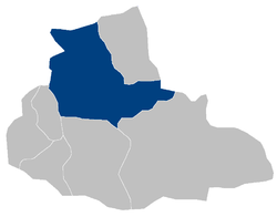 Murghab District within Badghis Province | |
 Murghab Location in Afghanistan | |
| Coordinates: 35°34′N 63°20′E / 35.567°N 63.333°ECoordinates: 35°34′N 63°20′E / 35.567°N 63.333°E | |
| Country | Afghanistan |
| Province | Badghis |
| Area | |
| • Land | 4,491 km2 (1,734 sq mi) |
| Population | |
| • Estimate (2003) | 109,381 |
Murghab (Pashto/Persian: مرغاب - Murġāb) is a district situated in the northeast of Badghis Province, Afghanistan. The district capital is Murghab city which is located along the Murghab River.
Demographics
The estimated population of Murghab District in 2003 was roughly 109,381.[1] Based upon the United Nation's High Commissioner for Refugees'(UNHCR) report, Pashtuns make up 85.6% of the total population, followed by 7% Tajiks, 7% Turkmen and 0.3% Uzbeks.[2]
Geography
Murghab is a hilly district located in the northeast of Badghis Province. Most of the population live in the valley of the Murghab River.
The district has 133 villages which covers an area of 4,491 km2. Murghab is surrounded by Turkmenistan, Muqur, Qadis, Jawand, Ghormach and Qaysar district of neighbouring Faryab Province.
Education
There are around 2 high schools, 3 secondary schools and 24 primary schools in the district.[3]
References
- UNHCR District Profile, compiled 2002-08-26, accessed 2006-05-05 (PDF).
- Dupree, Nancy Hatch (1977): An Historical Guide to Afghanistan. 1st Edition: 1970. 2nd Edition. Revised and Enlarged. Afghan Tourist Organization
External links
- Map of Murghab (PDF)