Mull
| Gaelic name | Muile |
|---|---|
| Pronunciation |
[ˈmulə] ( |
| Norse name | Myl |
| Meaning of name | pre-Gaelic |
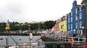
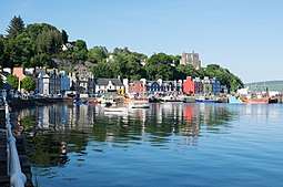 Tobermory waterfront | |
| Location | |
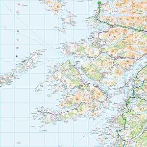
 Mull Mull shown within Argyll and Bute | |
| OS grid reference | NM590354 |
| Coordinates | 56°27′N 6°00′W / 56.45°N 6°W |
| Physical geography | |
| Island group | Mull |
| Area | 875.35 square kilometres (337.97 sq mi) |
| Area rank | 4 [1] |
| Highest elevation | Ben More 966 m |
| Administration | |
| Sovereign state | United Kingdom |
| Country | Scotland |
| Council area | Argyll and Bute |
| Demographics | |
| Population | 2990 (2011 Census) |
| Population rank | 8 [1] |
| Population density | 3.2 people/km2[2][3] |
| Largest settlement | Tobermory |
| References | [3][4][5] |
Mull (Scottish Gaelic: Muile) is the second largest island of the Inner Hebrides (after Skye), and lies off the west coast of Scotland in the council area of Argyll and Bute.
With an area of 875.35 square kilometres (337.97 sq mi), Mull is the fourth largest Scottish island and the fourth largest island surrounding Great Britain (excluding Ireland). In the 2011 census the usual resident population of Mull was 2,800[2] which was a slight increase on the 2001 figure of 2,667.[6] In the summer the population is supplemented by many tourists. Much of the population lives in Tobermory, the only burgh on the island until 1973, and its capital.
Tobermory is also home to Mull's only single malt Scotch whisky distillery: Tobermory distillery (formerly Ledaig).[7]
Geography
Mull has a coastline of 480 kilometres (300 mi) and its climate is moderated by the Gulf Stream. The island has a mountainous core; the highest peak on the island is Ben More, which reaches 966 metres (3,169 ft). Various peninsulas, which are predominantly moorland, radiate from the centre.
The Aros peninsula to the north includes the main town of Tobermory, which was a burgh until 1973 when burghs were abolished. Other settlements include Salen, Dervaig and Calgary. The Ross of Mull lies to the south west and includes the villages of Bunessan, Pennyghael, Uisken and Fionnphort. Lochbuie, Lochdon and Craignure lie to the east.
Numerous islands lie off the west coast of Mull, including Erraid, Inch Kenneth, Iona, Gometra, and Ulva. Smaller uninhabited islands include Eorsa, Little Colonsay, the Treshnish Isles and Staffa (of Fingal's Cave fame). Calve Island is an uninhabited island in Tobermory Bay. Two outlying rock lighthouses are also visible from the south west of Mull, Dubh Artach and Skerryvore. The Torran Rocks are a large shoal of reefs, islets and skerries, approximately 15 square miles (39 km2) in extent, located two miles (3 km) to the south west, between the Ross of Mull peninsula and Dubh Artach. Frank Lockwood's Island near Lochbuie is named after the brother-in-law of the 21st MacLean of Lochbuie, who was Solicitor General from 1894-5.[8]
Part of the indented west coast of Mull and some of the offshore islands there are part of the Loch Na Keal National Scenic Area, one of 40 in Scotland.[9]
History
Early history
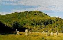
It is widely believed that Mull was inhabited from shortly after the end of the last Ice Age, around 6000 BC. Bronze Age inhabitants built menhirs, brochs and a stone circle with examples of burial cairns, cists, standing stones, pottery and knife blades provide compelling evidence.
Between 600 BC and AD 400, Iron Age inhabitants were building protective forts, duns and crannogs. Whether or not they were Picts is unclear.
In the 6th century, Irish migrants invaded Mull and the surrounding coast, establishing the Gaelic kingdom of Dál Riata. The kingdom was divided into a number of regions, each controlled by a kin group, of which the Cenél Loairn controlled Mull and the adjacent mainland to the east. Dál Riata was a springboard for the Christianisation of the mainland; the pivotal point was AD 563, when Columba, an Irish missionary, arrived at Iona (just off the south-west point of Mull) and founded a monastery, from which to start evangelising the local population.[10][11][12]
Norway
In the 9th century, Viking invasions led to the destruction of Dál Riata, and its replacement by the Norse Kingdom of the Isles, which became part of the kingdom of Norway following Norwegian unification. The Kingdom of the Isles was much more extensive than Dál Riata, encompassing also the Outer Hebrides and Skye. In Old Norse, the island kingdom became known as the Suðreyjar, meaning southern isles. The former lands of Dál Riata acquired the geographic description "Argyle" (now "Argyll"): the Gaelic coast.
In the late 11th century, Magnus Barefoot, the Norwegian king, launched a military campaign which, in 1098, led the king of Scotland to quitclaim to Magnus all claim of sovereign authority over the territory of the Kingdom of the Isles. However, a coup some 60 years later, led by a Norse-Gael named Somerled, detached the whole of the Suðreyjar from Norway, and transformed it into an independent kingdom. After Somerled's death in 1164, nominal Norwegian authority was established, but practical control of the realm was divided between Somerled's sons and the heirs of Somerled's brother-in-law, the Crovan Dynasty. His son Dougall received the former territory of the Cenél Loairn, now known as Lorn, of which Mull formed part.
Meanwhile, the Crovan dynasty had retained the title "king of the Isles", and control of Lewis/Harris, and the Isle of Man. After a few decades, they acknowledged the English kings as their overlords, so Dougall's heirs (the MacDougalls) complained to Haakon, the Norwegian king, and in 1237 were rewarded by the kingship being split; rule of the Hebrides was transferred to the MacDougall line, and they were made the "kings of the Hebrides". They established the twin castles of Aros (in Mull) and Ardtornish (on the mainland, opposite), which together controlled the Sound of Mull.
Throughout the early 13th century, the king of Scots, Alexander II, had aggressively tried to expand his realm into the Suðreyjar, despite Edgar's earlier quitclaim. This naturally led to hostility between Norway and Scotland, which continued under Alexander III, Alexander II's successor. The Norwegian king died shortly after the indecisive Battle of Largs. In 1266, his more peaceable successor ceded his nominal authority over the Suðreyjar to Alexander III by the Treaty of Perth, in return for a very large sum of money. Alexander generally acknowledged the semi-independent authority of Somerled's heirs; the former Suðreyjar had become Scottish crown dependencies, rather than parts of Scotland.
Lords of the Isles
At the end of the 13th century, a violent dispute arose over the Scottish kingship between King John Balliol and Robert de Bruys. By then, Somerled's descendants had formed into three families: as well as Dougall's heirs (the MacDougalls), there were also the heirs of his nephew Donald (the MacDonalds), and those of Donald's brother (the MacRory); the MacDougalls backed Balliol, while the MacDonalds and MacRory backed de Bruys. When de Bruys defeated John, he declared the MacDougall lands forfeit, and gave them to the MacDonalds and MacRory, with the latter acquiring Lorn (and hence, Mull). John, the head of the MacDonald family, then married the heir of the MacRory family, thereby consolidating the remains of Somerled's realm, and transforming it into the Lordship of the Isles.
In 1354, though in exile and without control of his ancestral lands, John, the MacDougall heir, quitclaimed any rights he had over Mull to the Lord of the Isles. When Robert's son David became king, he spent some time in English captivity; after his release, in 1357, he restored MacDougall authority over Lorn, effectively cancelling Robert's grant to the MacRory. The 1354 quitclaim, which seems to have been an attempt to ensure peace in just such an eventuality, took automatic effect, splitting Mull from Lorn, and making it subject to the Lordship of the Isles.
In 1437, the Lordship was substantially expanded when Alexander, the Lord of the Isles, inherited the rule of Ross maternally. The expansion led the MacDonalds to move their centre of power from Islay to the twin castles of Aros and Ardtornish.
In 1462, the most ambitious of the Lords of the Isles, John MacDonald, struck an alliance with Edward IV of England, to conquer Scotland. Civil war in England prevented this from taking effect and from being discovered, until 1475, when the English court voluntarily revealed its existence. Calls for forfeiture of the Lordship naturally followed, but they were calmed when John quitclaimed most of his mainland territories. However, ambition was not given up so easily, and John's nephew launched a severe raid on Ross, but it ultimately failed. Within two years of the raid, in 1493, James IV of Scotland declared the Lordship of the Isles forfeit, transforming the realm into an intrinsic part of Scotland, rather than merely a dependency.
MacLeans

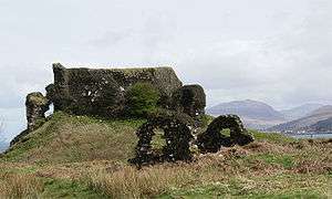
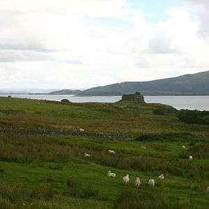
Throughout all this time, the descendants of the Cenél Loairn had retained their identity; they were now the MacLeans. Now that John MacDonald was exiled, James IV restored the authority of the MacLeans over Mull. An earlier chief of the MacLeans had married the daughter of the first Lord of the Isles, and received Duart Castle as the dowry; this now became the stronghold of MacLean control of Mull. The cadet branch of the family constructed a tower house at Moy, on the southern side of Mull, while the senior branch retained Duart Castle.
Legend has it that the wreck of a Spanish galleon, laden with gold, lies somewhere in the mud at the bottom of Tobermory Bay, although the ship's identity and cargo are disputed. By some accounts, the Florencia (or Florida, or San Francisco), a ship of the defeated Spanish Armada fleeing the English fleet in 1588, anchored in Tobermory to take on provisions. After a dispute over payment, the ship caught fire and the gunpowder magazine exploded, sinking the vessel. In her hold, reputedly, was £300,000 in gold bullion.[13] Other sources claim the vessel was the San Juan de Sicilia (or San Juan de Baptista), which, records indicate, carried troops, not treasure.[14][15] According to that account, the island's chief, Lachlan Mor Maclean, struck a deal with the Spanish commander to re-provision and refit the ship in return for military intervention on the side of the MacLeans in their feud with enemies on nearby islands.[16][17][18] Whatever the true story, there have been numerous searches for the wreck, and its rumoured treasure, from the mid-17th century to the end of the 20th century.[19] No significant treasure has yet been recovered in Tobermory Bay.[20]

Following the Scottish Reformation, the MacLeans became supporters of Protestantism. By the mid-17th century, they had become promoters of conventicles, opposed to king Charles II's repudiation of the Solemn League and Covenant, and supporting acts of civil disobedience. Though personally opposed to persecution of such people, Archibald Campbell, the Earl of Argyll, was specifically ordered by the Scottish privy council to suppress conventicles within his lands, which included Lorn. The atmosphere of hostility soon spread to Mull, where opponents of the conventicles now felt emboldened, leading to outbreaks of violence between the two religious factions.
In 1678, Campbell was specifically instructed to seize Mull, and suppress both the violence and conventicles. It took him until 1680 to gain possession of the whole island. Campbell took charge of Duart Castle, and ejected the MacLean leadership from Mull; they moved to Cairnbulg Castle in Aberdeenshire. Campbell's own position was somewhat undermined when he instigated Argyll's Rising, against the reign of James VII. The loyalty of subsequent Campbell leaders ensured the Campbells retained possession of Duart (indeed, it was only after the Campbells sold it, and it had spent a century under other owners, that the MacLeans were able to recover it, by purchase). Under Campbell pressure, shrieval authority was established under the sheriff of Argyll, which they controlled.
Later history
Following Jacobite insurrections, the Heritable Jurisdictions Act abolished comital authority in Mull, and Campbell control of the Argyll sheriffdom; the Campbells could now only assert influence as Landlords. Many castles which had been in the hands of the MacLeans (such as Moy) had been slighted by the Campbells, or fallen into disrepair, but more comfortable homes were built nearby.
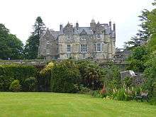
In 1773 the island was visited by Samuel Johnson and James Boswell during their famous Tour of the Western Islands. Farming, fishing and burning seaweed for kelp ash (used in the manufacture of soap and glass) were the main economic activities on the island until the 19th century. Tobermory was built by the British Fisheries Society in 1788, as a planned settlement to support the fishing industry. Following the Highland Clearances in the 18th and 19th centuries, and the Highland Potato Famine, the population fell from 10,000 to less than 3,000 and the island economy collapsed. Despite this, several grand houses were built on Mull in the period, including Torosay "Castle". By the early 20th century there were more sheep than people.
In 1889, counties were formally created in Scotland, on shrieval boundaries, by a dedicated Local Government Act; Mull therefore became part of the newly created County of Argyll.
The whole island became a Restricted Area during World War II. The bay at Tobermory became a naval base commanded from HMS Western Isles. The base and the Restricted Area were under Commodore (later Vice Admiral) Sir Gilbert Stephenson, whose strict discipline and ferocious temper earned him the nickname "The Terror of Tobermory".[21] The base was used to train Escort Groups in anti-submarine warfare. 911 ships passed through the base between 1940 and 1945. Following late 20th century reforms, Mull is now part of the wider area of Argyll and Bute.
Economy
The economy began to revive when the construction of Craignure Pier in 1964 started to bring tourists. Tourism is now the mainstay of the island's economy. Ecotourism became popular from the 1990s, and the reintroduction of white-tailed eagles in 2005 became a particular ecotourist attraction.[22]
There is a small amount of farming, aquaculture and fishing, and Forestry Commission Scotland has several plantations on the island. Tobermory also has one whisky distillery (Tobermory distillery) and from 2005 to 2009 had a brewery (Isle of Mull brewing company).[23]
Isle of Mull cheese is Scottish Cheddar cheese made from raw cow milk produced on the Isle of Mull.[24]
Transport
Ferries
Ferry links to Mull from the mainland include:
- the most used ferry, from Oban to Craignure (approx. 45 minutes),
- Kilchoan to Tobermory (approx. 35 minutes)
- Lochaline to Fishnish (approx. 15 minutes).
Advance bookings are not required for the Kilchoan or Fishnish ferries; access to those two ferry terminals on the mainland side is via single-track roads.
There are also ferry links from Fionnphort on Mull to the neighbouring island of Iona and from Oskamull to Ulva. In past years there were direct sailings to Oban (calling at Drimnin, Salen, Lochaline and Craignure), and to Barra, Coll and Tiree from Tobermory. During the summer there was also a sailing to Staffa and Iona from Oban which called at Tobermory.
Buses
Buses are operated by West Coast Tours Ltd. There are routes from Tobermory to Calgary via Dervaig (Service 494), Tobermory to Craignure via Salen (Service 495), and Craignure to Fionnphort via Bunessan (Service 496). Limited services operate to Lochbuie and Gruline.[25] West Coast Tours also provide guided tours around Mull, Iona and Staffa, including boat transfers.
A minibus service also operates seasonally from Craignure to Duart Castle.[26]
Airstrip
One can fly to Mull in a private light aircraft using a landing strip near Salen.[27] There was a seaplane that linked Tobermory with Glasgow and Oban. The regular scheduled service terminated in 2009. Loganair operated a scheduled service to Glasgow in the 1960s from Glenforsa airfield, a 780-metre-long (2,560 ft) grass airstrip constructed by the Royal Engineers in 1965 near Salen. The airstrip has been operated since 2014 by pilots Brendan and Allison Walsh, owners of the adjacent Glenforsa Hotel.
Tourist railway
The Isle of Mull Railway ran the short distance from Craignure to Torosay Castle, but closed in 2011.
Schooling
There is one secondary school on the island (Tobermory High School, which includes a Gaelic medium education unit) and six primary schools. Salen Primary School has a Gaelic medium education unit. Secondary pupils (age 11 - 18) from Iona, Bunessan and Fionnphort in the south west attend Oban High School, staying in an Oban hostel from Monday to Thursday.
Communications
Mull was connected to the mainland by a submarine telegraph cable between Oban and Grass Point in 1871. There were telegraph offices at Tobermory, Dervaig, Calgary, Craignure, Pennyghael, Tiroran, Fionnphort, Bunessan and Iona.[28]
The Post Office built an experimental wireless telegraph station on Meall an Inbhire near Tobermory in 1892.[29]
AM radio, broadcast from Oban, came to the island in 1930 and television in 1954. New AM radio and UHF television transmitters were constructed on Druim Mòr, 1 mile west of Torosay Castle, in 1978. Digital transmissions commenced on 15 November 1998 and analogue transmissions ceased on 27 October 2010. The digital transmitters have 22 relays on Mull, surrounding islands and parts of the mainland, collectively the Torosay Transmitter Group.[30]
In 2014, fibre optic cables for support of high speed internet were laid between Kilchoan (in Ardnamurchan) and Tobermory, and between Dunstaffnage (near Oban) and Torosay. In February 2015 additional cables were laid underground between Tobermory and Torosay to provide a complete link.
Media and the arts
Part of Robert Louis Stevenson's 'Kidnapped' is set on Mull. David Balfour is in fact briefly stranded on the islette of Erraid, to the south-west of Mull and it is to Mull that he journeys, on the fourth day of his shipwreck, after discovering a low-water passage between Erraid and Mull.
Mull has been used as a location in a number of feature films over the years. These include I Know Where I'm Going (1945), Kidnapped (1971), When Eight Bells Toll (1971), Madame Sin (1972), Eye of the Needle (1981), The Sea Change (1998)[31][32], Entrapment (1999), Highlander: Endgame (2000) and Blooded (2011).

The BBC children's TV series Balamory features the town of Tobermory on the island. This provided an additional tourist attraction on the island. Grand Tours of Scotland, a TV series featured Mull as one of the islands visited in the series.
Mull Theatre is a professional theatre company based in a new (2008) theatre production centre on the outskirts of Tobermory.[33] The company commissions plays, tours throughout Scotland and beyond and runs an education and outreach programme. It started at the "Mull Little Theatre" at Dervaig in 1966 and was the "Smallest Professional Theatre in the World" according to the Guinness World Records. The National Theatre of Scotland were in residence at the Mull Theatre in April 2009.
An Tobar ("The Well"), based in Tobermory, is the only publicly funded multidisciplinary arts centre in Argyll. Established in 1997, it is a centre for visual arts, crafts and music.[34] With effect from 1 April 2013, An Tobar and the Mull Theatre were brought together as Comar
Wildlife film-maker Simon King went on location to Mull for the first week of Springwatch with Bill Oddie, and observed a resident family of white-tailed eagles: a male (Skye), a female (Frisa), and their two chicks, Itchy and Scratchy. Wildlife cameraman Gordon Buchanan recently returned to his native Mull to film a year in the life of the wildlife. First broadcast in 2005 for the Natural World series, "Eagle Island" focuses on sea eagles, golden eagles, otters, basking sharks and the cetaceans found off the coast.[35]
The singer-songwriter Colin MacIntyre famously uses the name Mull Historical Society as a pseudonym. Born on the island, he took the name from the actual Historical Society, which has since changed its name to Mull Historical and Archaeological Society
Natural history
The Isle of Mull is a popular destination for naturalists and photographers as it is one of the primary spots in the UK for seeing some of Britain's more elusive species. Information about the island's wildlife (including species lists, photographs and distribution data) is being compiled on a website called Wild Mull.[36]
Mull has over 800 species of vascular plant (684 native and 171 naturalised) including 33 species of fern,[36] at least 18 species of orchid and 22 native species of tree. There are about 700 species of lichen, 571 liverworts and mosses and 247 marine algae (seaweeds), making a total of 2,388 species of plant recorded from the island. In addition, more than 2,000 species of fungi have been recorded on Mull: in their 1983 paper about the fungi of the Inner Hebrides, Dennis and Watling say, "When one speaks of the Inner Hebridean fungi one is referring to the floras of Mull and Rhum".[37]
The island has 261 different bird species, including the white-tailed eagle, which was reintroduced to the nearby island of Rùm and migrated to Mull, where it now has a stronghold. Basking sharks, minke whales, porpoises and dolphins are among the sea life that can be seen on boat tours from Mull.
The island is home to a thriving population of otters that live in coastal habitat, hunting during the day.[38] The Mull Otter Group has been established to create positive awareness regarding the conservation needs of otters on the Isle of Mull.[39]
The island also has several birds of prey, such as hen harriers,[40] golden eagles,[41] and short eared owls:[42] all difficult species to see throughout the rest of the UK. Pine martens have also recently become established on Mull;[43] based on sighting records, and from resulting modelling exercises, it is believed the species arrived in 2004 through accidental transportation on timber boats from the mainland. According to a paper by Scottish Natural Heritage it is unlikely that pine martens have ever been native to the Isle of Mull.[44]
The Hebridean Whale and Dolphin Trust was established in 1994 as a registered charity to pioneer practical, locally based education and monitoring programmes on cetaceans (whales, dolphins and porpoises) in the Hebrides.[45] The Trust is based at Tobermory, where it has its main, education and research offices and a visitor centre.
There are also a number of invasive non-native species that occur on the island, including invasive plant species such as Japanese knotweed,[46] and invasive animals such as feral cats and American mink[47] that are believed to be causing damage to the indigenous species populations through competition and predation.[36]
Sport
The Tour of Mull is a closed road rally event held on the island every October. While some well off competitors benefit from superior cars, the locals benefit from their knowledge of the roads and thus anyone can win. "The Best Rally In The World" is the title of a book written by the founder of the event, Brian Molyneux. Previously sponsored by Philips, it has been sponsored since 2005 by Tunnock's, the Lanarkshire biscuit manufacturer.[48][49]
There are several shipwrecks around the shores which offer scuba diving.
There is an Isle of Mull Cycling Club.
The Cross at the Castle cyclocross event is held annually at Glengorm Castle near Tobermory and features the World Santacross Championships and the Scottish Singlespeed Cylocross Championships.
Mull Runners organise a half marathon and 10K run each August between Craignure and Salen.
Rugby is played at Garmony (beside the Craignure to Salen road 6.5 miles north of Craignure). The Mull Rugby 7s Competition takes place annually in May at The Isle of Mull R.F.C's rugby club.
There are golf courses at Tobermory (Erray Park), Craignure (beside the Craignure to Salen road a mile north of Craignure) and on the Isle of Iona.
Mull Highland Games are held each July in the grounds of Tobermory Golf Club (Erray Park). Events include Heavy Weights, Light Field, and Highland Dance.
There is a swimming pool at the Isle of Mull Hotel, Craignure open to the general public.
There are tennis courts in Tobermory. Apply at the Argyll and Bute Council Offices, Breadalbane Street, Tobermory for details.
Football is played, mainly in the south end. Bunessan F.C. play a number of games during the summer, most notobly against arch rivals Iona FC, the island just off the south west end of Mull. Bunessan F.C. also hold an annual 5-a-side tournament in July.
Community initiatives
Following research and community consultation in 1996/97, a development trust was created to identify key goals for the communities of Mull and Iona. Mull & Iona Community Trust (MICT)[50] was formed in 1997 and published a comprehensive "Community Regeneration Strategy" for the islands. They have purchased the only butcher's shop on the island (closed February 2010), created a community-run Countryside Ranger service, instigated various recycling initiatives and provide a fundraising and training consultancy.[51]
Notable residents
.jpg)
- Mary Macleod (Mairi Nighean Alasdair Ruaidh), a 17th-century poet, is said to have been banished to Mull.[52]
- Lachlan Macquarie, (1762-1824) was born on the nearby island of Ulva.[53] He became Governor of New South Wales from 1809 to 1822, and is known as "The Father of Australia".[54] His mausoleum can be found near his old patrimonial estate near Gruline and is maintained at the expense of the National Trust of Australia.[55]
- Mary MacDonald (1789–1872) from Ardtun wrote a hymn to the traditional melody Bunessan, best known today as the tune of Morning has Broken.[56]
See also
References
- Baird, Bob (1995) Shipwrecks of the West of Scotland. Glasgow. Nekton Books. ISBN 1-897995-02-4
- Currie, Jo. (2001) Mull: The Island and Its People. Birlinn Ltd.
- Jermy, A.C. and Crabbe, J.A. (Ed) (1978) The Island of Mull a Survey of its Flora and Environment. London. British Museum (Natural History).
- Mull Theatre
Footnotes
- 1 2 Area and population ranks: there are c. 300 islands over 20 ha in extent and 93 permanently inhabited islands were listed in the 2011 census.
- 1 2 National Records of Scotland (15 August 2013) (pdf) Statistical Bulletin: 2011 Census: First Results on Population and Household Estimates for Scotland - Release 1C (Part Two). "Appendix 2: Population and households on Scotland’s inhabited islands". Retrieved 17 August 2013.
- 1 2 Haswell-Smith, Hamish (2004). The Scottish Islands. Edinburgh: Canongate. ISBN 978-1-84195-454-7.
- ↑ Ordnance Survey. OS Maps Online (Map). 1:25,000. Leisure.
- ↑ Anderson, Joseph (Ed.) (1893) Orkneyinga Saga. Translated by Jón A. Hjaltalin & Gilbert Goudie. Edinburgh. James Thin and Mercat Press (1990 reprint). ISBN 0-901824-25-9
- ↑ General Register Office for Scotland (28 November 2003) Scotland's Census 2001 – Occasional Paper No 10: Statistics for Inhabited Islands. Retrieved 26 February 2012.
- ↑ Tobermory Distillery tobermory.co.uk Archived 15 May 2011 at the Wayback Machine. Retrieved 2010-07-10.
- ↑ Baird (1995) p. 142
- ↑ "National Scenic Areas" Archived 11 March 2017 at the Wayback Machine.. SNH. Retrieved 30 Mar 2011.
- ↑ Susan Crane (29 November 2012). Animal Encounters: Contacts and Concepts in Medieval Britain. University of Pennsylvania Press. p. 11. ISBN 0-8122-0630-4.
- ↑ Nicholas Ostler (23 February 2016). Passwords to Paradise: How Languages Have Re-invented World Religions. Bloomsbury Publishing. p. 192. ISBN 978-1-62040-517-8.
- ↑ Norbert Brockman (13 September 2011). Encyclopedia of Sacred Places. ABC-CLIO. p. 238. ISBN 978-1-59884-654-6.
- ↑ A Clan Feud, a Spanish Galleon, and a Big Bang. lostfort.blogspot.com Retrieved 10 July 2010.
- ↑ The Galleon San Francisco. shipmodeling.net Retrieved 2010-07-10.
- ↑ The Tobermory Wreck. news.scotsman.com Retrieved 2010-07-10.
- ↑ Martin, Colin; Parker, Geoffrey (1988), The Spanish Armada, New York: W. W. Norton & Company, p. 244, ISBN 0-393-02607-8
- ↑ Campbell of Airds, Alastair (2002), A History of Clan Campbell; Volume 2; From Flodden to the Restoration, Edinburgh: Edinburgh University Press, p. 95, ISBN 1-902930-18-5
- ↑ Lewis, Michael (1960), The Spanish Armada, London: B. T. Batsford Ltd
- ↑ Martin, Colin (1975), Full Fathom Five: Wrecks of the Spanish Armada, New York: The Viking Press, p. 58, ISBN 0-670-33193-7
- ↑ Tobermory Bay. reese.org Archived 21 July 2011 at the Wayback Machine. Retrieved 2010-07-10.
- ↑ Baker, Richard (1972). The Terror of Tobermory: Vice-Admiral Sir Gilbert Stephenson, KBE, CB, CMG. W.H. Allen. ISBN 978-1-84158-197-2.
- ↑ "Wildlife at work: The economic impact of white-tailed eagles on the Isle of Mull" (PDF). Royal Society for the Protection of Birds. 3 Mar 2011.
- ↑ "Isle of Mull Brewing Company". Today's Breweries. ScottishBrewing.com. Retrieved 17 August 2016.
- ↑ Cheese For Dummies - Culture Magazine, Laurel Miller, Thalassa Skinner. p. 144.
- ↑ "Archived copy". Archived from the original on 22 July 2011. Retrieved 6 March 2010.
- ↑ "Archived copy". Archived from the original on 28 July 2012. Retrieved 21 March 2010.
- ↑ "Transport Links" The Glen Forsa Hotel. Retrieved 14 July 2008.
- ↑ P. A. Macnab (1970). The Isle of Mull. David & Charles. p. 129.
- ↑ "Electrical engineering". 9. 1913: 623.
- ↑ "Torosay and relays". UK Free TV. Retrieved 9 October 2018.
- ↑ "The Sea Change" theseachange.wordpress.com. Retrieved 30 December 2008.
- ↑ "The Sea Change" Archived 6 November 2008 at the Wayback Machine. tailormadeproductions.com. Retrieved 30 December 2008.
- ↑ "Druimfin, the new home for Mull Theatre". Mull Theatre. Retrieved 2009-07-26.
- ↑ "Welcome to AN TOBAR, Tobermory, Isle of Mull" antobar.co.uk. Retrieved 21 June 2010.
- ↑ "Eagle Island with Gordon Buchanan" Archived 11 October 2008 at the Wayback Machine. Mike Birkhead Associates. Retrieved 21 June 2008.
- 1 2 3 "Home - Wild Mull". Archived from the original on 2015-12-22.
- ↑ Dennis, R.W.G., Watling, R. 1983. Fungi in the Inner Hebrides. In The Natural Environment of the Inner Hebrides, Edited by John Morton Boyd and D.R. Bowes, Volume 83, January 1983, pp 415-429
- ↑ "Lutra lutra". Wild Mull. Retrieved 24 October 2015.
- ↑ "Mull Otter Group". Mull Otter Group. Retrieved 24 October 2015.
- ↑ "Circus cyaneus". Wild Mull. Retrieved 24 October 2015.
- ↑ "Aquila chrysaetos". Wild Mull. Retrieved 24 October 2015.
- ↑ "Asio flammeus". Wild Mull. Retrieved 24 October 2015.
- ↑ "Martes martes Wild Mull". Retrieved 24 October 2015.
- ↑ Roy, S., Milborrow, J., Allan, J. and Robertson, P. 2012. Pine martens on the Isle of Mull – Assessing risks to native species. Scottish Natural Heritage Commissioned Report No.560
- ↑ "Hebridean Whale and Dolphin Trust". Hebridean Whale and Dolphin Trust. Retrieved 24 October 2015.
- ↑ "Reynoutria japonica". Wild Mull. Retrieved 24 October 2015.
- ↑ "Neovison vison". Wild Mull. Retrieved 24 October 2015.
- ↑ "Tunnock's Tour of Mull" 2300club.org. Retrieved 24 April 2011.
- ↑ "Tour of Mull Rally 1969-2002" Archived 19 August 2013 at the Wayback Machine. Mullcarclub.co.uk. Retrieved 27 September 2008.
- ↑ "Mull and Iona Community Trust".
- ↑ DTA Scotland Directory of Members Archived 3 April 2009 at the Wayback Machine.
- ↑ Thomson, Derick S. "Màiri nighean Alasdair Ruaidh". Oxford Dictionary of National Biography (online ed.). Oxford University Press. doi:10.1093/ref:odnb/17675. (Subscription or UK public library membership required.)
- ↑ McLachlan, N. D. (1967). "Macquarie, Lachlan (1762–1824)". Australian Dictionary of Biography. Canberra: Australian National University. Retrieved 7 June 2009.
- ↑ "GOVERNOR MACQUARIE". The Sydney Morning Herald. National Library of Australia. 1 March 1913. p. 7. Retrieved 12 November 2012.
- ↑ http://www.mq.edu.au/about/about-the-university/the-macquarie-story/history/macquaries-influence
- ↑ Explore Mull: Mary Macdonald’s Memorial (picture and directions)
External links
| Wikimedia Commons has media related to Isle of Mull. |
| Wikivoyage has a travel guide for Mull. |
| Main settlements | 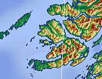 | |
|---|---|---|
| Smaller settlements | ||
| Geographical features | ||
| History and architecture | ||
| Local culture and economy | ||
| Surrounding islands | ||
Inhabited islands of the Hebrides | ||
|---|---|---|
| Inner Hebrides | 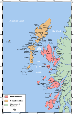 | |
| Outer Hebrides | ||
|  | ||||||||||||||||
|
| |||||||||||||||||
| |||||||||||||||||
| |||||||||||||||||
| |||||||||||||||||
| |||||||||||||||||
| |||||||||||||||||
| |||||||||||||||||