Eildon Hill
| Eildon Hill | |
|---|---|
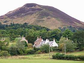 Eildon Hill North, with Eildon Village in the foreground | |
| Highest point | |
| Elevation | 422[1] m (1,385 ft) |
| Prominence | c. 164 m |
| Listing | Marilyn |
| Naming | |
| Translation | possibly "Elves Hill" or "Fort Hill"[1] (Old English) |
| Pronunciation | /ˈiːldən/ |
| Geography | |
| Location | Scottish Borders, Scotland |
| Parent range | According to Nuttall, the 1,385 feet (422 m) high "triple-crested eminence" overlooks Teviotdale to the South. |
| OS grid | NT548322 |
| Topo map | OS Landranger 73[1] |
- Not to be confused with Eldon Hill, England
Eildon Hill lies just south of Melrose, Scotland in the Scottish Borders, overlooking the town. The name is usually pluralised into "the Eildons" or "Eildon Hills", because of its triple peak. The 422 metres (1,385 ft) high eminence overlooks Teviotdale to the South.[1] The north hilltop (of three peaks) is surrounded by over 5 km (3.1 mi) of ramparts, enclosing an area of about 16 ha (40 acres) in which at least 300 level platforms have been cut into the rock to provide bases for turf or timber-walled houses, forming one of the largest hill forts known in Scotland.[2] A Roman army signalling station was later constructed on the same site as this hill fort.[3]
The mid hilltop is the highest, whilst the south hilltop is the lowest. The hills are owned by the Duke of Buccleuch,[4] Scotland's largest private landowner.[5] As with all land in Scotland the public have a right of responsible access to the hills,[6] and there are many paths crossing the area and leading to all three summits.[7]
The hills form part of the Eildon and Leaderfoot National Scenic Area, one of forty such areas in Scotland, which have been defined so as to identify areas of exceptional scenery and to ensure its protection from inappropriate development.[8] The areas protected by the national scenic area (NSA) designation are considered to represent the type of scenic beauty "popularly associated with Scotland and for which it is renowned".[9] The Eildon and Leaderfoot NSA covers 3877 ha,[10] and extends to include the town of Melrose, Scott's View and Leaderfoot Viaduct.[11]
History
| Eildon and Leaderfoot National Scenic Area | |
|---|---|
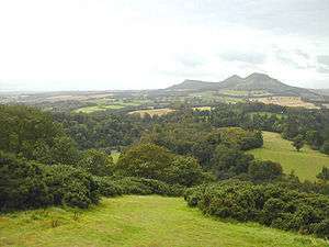 The three peaks of Eildon Hill seen from Scott's View | |
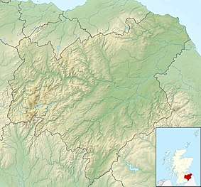 Location in the Scottish Borders. | |
| Location | Scottish Borders |
| Coordinates | 55°34′53″N 2°43′07″W / 55.58134°N 2.71855°WCoordinates: 55°34′53″N 2°43′07″W / 55.58134°N 2.71855°W |
| Area | 39 km2 (15 sq mi)[10] |
| Established | 1981 |
| Governing body | Scottish Natural Heritage |
Excavations have found evidence that the hill fort was occupied by 1000 BC, in the Bronze age. The ramparts seem to have been built and rebuilt in three phases. 296 individual huts floors have been identified witihn the fort, suggesting a population of around 2000, and making it one of the largest known in Scotland from this period.[2] The hill fort is thought to have been the capital of the Selgovae, who lived in the upper tweed area prior to the arrival of the Romans.[2]
In the 1st century CE the Roman army built the massive fort of Trimontium at Newstead, named after the three peaks, at the foot of the hill on the bank of the River Tweed. In association with this fort they constructed a signal tower with a tiled roof in a 15 m diameter enclosure built on the summit of Eildon North Hill.[3] The hill fort may have been abandoned by this time, as Roman archaeological finds uncovered during excavation of the site in 1986 all overlaid native finds.[2] The tower was thought to have been constructed out of timber during the Flavian period, with a later tower being constructed out of stone during the reign of Emperor Antoninus Pius. Finds including Roman coins and pottery have suggested that some of the house platforms were again in use in the 2nd to 4th century.[2]
There is some evidence that prehistoric peoples regarded the Eildon Hills as a holy place and scholars believe they may have been a place of ceremonial gatherings. There are several holy springs around the base of the hills, now dedicated to Christian saints, but probably originally sacred to Celtic deities.[12]
Formation
It is possible that the hills were formed deep beneath the Earth's surface as ancient laccoliths.
Folklore
Eildon is said to be a "hollow hill", and is mentioned in the legend of Thomas the Rhymer. Some believe Thomas went under the hill itself, and certainly part of the ballad occurs in the vicinity. Sir Walter Scott tells the tale of a horse dealer who is paid in 'ancient coin' by an elderly buyer in old-fashioned dress and taken inside the hill at night. A host of armed knights lie asleep at their horses' feet; their sleeping leader is King Arthur. Shown a horn and a sword, in confusion the dealer blows the horn: the men begin to awake and a loud voice indicates that he has been proved a coward for not seizing the sword first. A whirlwind ejects him from the chamber and outside he tells his story to some shepherds before dropping dead of exhaustion. Scott identifies the elderly man as Thomas the Rhymer.[13][14]
The volcanic rock was said to have been cleft in three by the wizard Michael Scot, as relayed by Walter Scott in his 1805 poem The Lay of the Last Minstrel:
In these far climes it was my lot
To meet the wondrous Michael Scott,
A wizard, of such dreaded fame,
Than when, in Salmanca's cave,
Him listed his magic wand to wave,
The bells would ring in Notre Dame!
Some of his skill he taught to me;
And Warrior, I could say to thee
The words that cleft Eildon hills in three,
And bridled the Tweed with a curb of stone:
But to speak them were a deadly sin.
This story was repeated by James Hogg in his 1823 novel The Three Perils of Man.
Media
This place was cited in the lyric 'Eiledon', from Big Country's 'The Seer' album.[15]
See also
Notes
- 1 2 3 4 R. Milne & H. Brown, The Corbetts and Other Scottish Hills, p. 29. Published by the Scottish Mountaineering Trust, 2002.
- 1 2 3 4 5 "Eildon Hill North: Fort (Prehistoric)". Historic Environment Scotland. Retrieved 2018-03-02.
- 1 2 "Eildon Hill North Signal Station (Roman)". Historic Environment Scotland. Retrieved 2018-03-02.
- ↑ "Proprty Page - Buccleuch (Eildon)". Who Owns Scotland. 2008-03-12. Retrieved 2018-03-05.
- ↑ Ross, David (5 June 2013). "Questions raised over land swap deal with billionaire". The Herald. Retrieved 12 January 2015.
- ↑ "Scottish Outdoor Access Code" (PDF). Scottish Natural Heritage. 2005. Archived from the original (PDF) on 2015-09-23. Retrieved 2018-01-16.
- ↑ "Walks Around Melrose" (PDF). Scottish Borders Council. 2010. Retrieved 2018-03-05.
- ↑ "National Scenic Areas". Scottish Natural Heritage. Retrieved 2018-01-17.
- ↑ "Countryside and Landscape in Scotland - National Scenic Areas". Scottish Government. 2017-07-04. Retrieved 2018-01-31.
- 1 2 "National Scenic Areas - Maps". SNH. 2010-12-20. Retrieved 2018-01-24.
- ↑ "Eildon and Leaderfoot National Scenic Area Map" (PDF). Scottish Natural Heritage. 2010-12-20. Retrieved 2018-03-03.
- ↑ http://www.scotborders.gov.uk/pdf/22592.pdf%5Bpermanent+dead+link%5D
- ↑ http://www.magicdragon.com/Wallace/lore.html
- ↑ http://www.britannia.com/history/arthur/eildon.html
- ↑ "Big Country - Eiledon Lyrics". SongLyrics.com. Retrieved 2018-03-05.