Eilean dà Mhèinn
| Gaelic name | Eilean dà Mhèinn |
|---|---|
| Meaning of name | island of two mines |
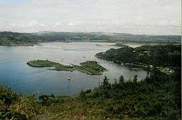 Eilean dà Mhèinn in Loch Crinan | |
| Location | |
 Eilean dà Mhèinn Eilean dà Mhèinn shown within Argyll and Bute | |
| OS grid reference | NR781944 |
| Coordinates | 56°05′28″N 5°34′01″W / 56.091°N 5.567°W |
| Physical geography | |
| Island group | Islay |
| Area | c. 3 hectares (7.4 acres) |
| Highest elevation | 16 m (52 ft) |
| Administration | |
| Sovereign state | United Kingdom |
| Country | Scotland |
| Council area | Argyll and Bute |
| Demographics | |
| Population | 1[1] |
| Population rank | 89= [2] |
| References | [3] |
Eilean dà Mhèinn, is a small inhabited island in Loch Crinan and one of the Inner Hebrides of Scotland.
It is about 100 metres (330 ft) to the west of the village of Crinan in Knapdale at high tide and only a fraction of that distance from the mainland shore at low tide.[3]
Although apparently not permanently inhabited in 2001[4] according to the 2011 census there was a single inhabitant at that time.[1] It has a landing stage on the eastern shore and a building near the centre of the island.[3] The crowded harbour at Crinan has so many moorings that "it is no longer possible to anchor to the south or east" of the island.[5]
Eilean dà Mhèinn is part of the Knapdale National Scenic Area, one of 40 in Scotland.[6]
Notes
- 1 2 National Records of Scotland (15 August 2013) (pdf) Statistical Bulletin: 2011 Census: First Results on Population and Household Estimates for Scotland - Release 1C (Part Two). "Appendix 2: Population and households on Scotland’s inhabited islands". Retrieved 17 August 2013.
- ↑ Area and population ranks: there are c. 300 islands over 20 ha in extent and 93 permanently inhabited islands were listed in the 2011 census.
- 1 2 3 Ordnance Survey. OS Maps Online (Map). 1:25,000. Leisure.
- ↑ General Register Office for Scotland (28 November 2003) Scotland's Census 2001 – Occasional Paper No 10: Statistics for Inhabited Islands. Retrieved 26 February 2012.
- ↑ Haswell-Smith (2004) p. 31
- ↑ "National Scenic Areas". SNH. Retrieved 6 September 2013.
References
- Haswell-Smith, Hamish (2004). The Scottish Islands. Edinburgh: Canongate. ISBN 978-1-84195-454-7.
| Wikimedia Commons has media related to Eilean dà Mhèinn. |
Coordinates: 56°5′28″N 5°34′4″W / 56.09111°N 5.56778°W
|  | ||||||||||||||||
|
| |||||||||||||||||
| |||||||||||||||||
| |||||||||||||||||
| |||||||||||||||||
| |||||||||||||||||
| |||||||||||||||||
| |||||||||||||||||