Coigach
Coigach
| |
|---|---|
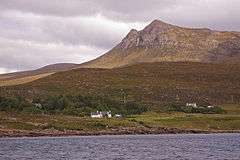 The township of Achduart, with Cairn Conmheall in the background. | |
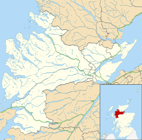 Coigach Coigach shown within the Ross and Cromarty area | |
| Population | 228 [1] |
| OS grid reference | NC025085 |
| Community council |
|
| Council area | |
| Lieutenancy area | |
| Country | Scotland |
| Sovereign state | United Kingdom |
| Post town | ULLAPOOL |
| Postcode district | IV26 |
| Dialling code | 01854 |
| Police | Scottish |
| Fire | Scottish |
| Ambulance | Scottish |
| EU Parliament | Scotland |
| UK Parliament | |
| Scottish Parliament | |
Coigach (Scottish Gaelic: 'A' Chòigeach') refers to the peninsula north of Ullapool, in Wester Ross in the Northwest Highlands of Scotland. The area consists of a traditional crofting and fishing community of a couple of hundred houses located between mountain and shore on a peninsula looking over the Summer Isles and the sea. The main settlement is Achiltibuie. Like its northerly neighbour, Assynt in Sutherland, Coigach has mountains which rise sharply from quiet, lochan-studded moorland, and a highly indented rocky coast with many islands, bays and headlands.[2] The highest summit is Ben Mor Coigach at 743 metres; the distinctive profile of Stac Pollaidh is the other main peak within Coigach.[3] The scenic qualities of Coigach, along with neighbouring Assynt, have led to the area being designated as the Assynt-Coigach National Scenic Area,[4] one of 40 such areas in Scotland.[5]
The name is derived from the Gaelic for "five" or "fifths",[6][7][8] and refers to the five townships of Achduart, Achnacarinan, Acheninver, Achnahaird and Achiltibuie.[9]
Local government
Coigach formed a barony of the civil parish of Loch Broom. In 1690 it was transferred into the county of Cromartyshire,[10] and indeed it was the largest single portion of land in the county,[11] which consisted of a series of unconnected exclaves. Until changes in civil registration districts in 1857[12] the barony also included Isle Martin, the lands down to Corrie beyond Ullapool, the various farms of Strathkanaird and to the east the Forest of Achall and Rhiddorach.
The Local Government (Scotland) Act 1889 provided that "the counties of Ross and Cromarty shall cease to be separate counties, and shall be united for all purposes whatsoever, under the name of the county of Ross and Cromarty", and Coigach thus became part of Ross and Cromarty. Although the counties were replaced by a system of regional and district councils in 1975 Coigach remains part of Ross and Cromarty for purposes such as land registration and lieutenancy. The regions and districts were replaced by unitary councils in 1996, and Coigach now forms a community within Highland council area.[3]
In 2010 a community development company was established on the initiative of the community council. Key issues to be addressed by the company are affordable housing, the provision of health services, the ageing demographic profile of the area and promoting economic development. The lack of tourist facilities, and of a ‘brand’ for Coigach, were also concerns.[13] A subsidiary of the Coigach Community Development Company, Coigach Wind Power, operates a 500 kW wind turbine to raise funds for the development company's projects.[14]
Conservation
The Coigach and Assynt Living Landscape Project is a community partnership project which aims to bring environmental and economic benefits to the Coigach and Assynt regions of North West Scotland. The partnership includes landowners (private and community), the local community and charitable organisations, with the Scottish Wildlife Trust being the lead partner. The project is described as an "ecosystem restoration project", and aims to "bring woodland connectivity, species-rich flora and fauna, and economic growth back to the Scottish uplands".[15]
References
- ↑ "Standard Outputs 2011 (Output Areas S00117989 & S00119174)". National Records of Scotland. Retrieved 2018-02-13.
- ↑ "The special qualities of the National Scenic Areas" (PDF). Scottish Natural Heritage. 2010. Retrieved 2018-01-24.
- 1 2 "Coigach Community Council Boundary" (PDF). Highland Council. April 2011. Retrieved 2018-02-13.
- ↑ "Map: Assynt-Coigach National Scenic Area" (PDF). Scottish Natural Heritage. 2010-12-20. Retrieved 2018-02-10.
- ↑ "National Scenic Areas". Scottish Natural Heritage. Retrieved 2018-01-17.
- ↑ Shirra, Kirstie (21 March 2011). "Scotland's Best Small Mountains: Cicerone Press". Cicerone Press Limited – via Google Books.
- ↑ "Dictionary Detail - cóigeach".
- ↑ Murray, W.H. (1968). The Companion Guide to the West Highlands of Scotland. London and Glasgow: Collins. p. 325.
The name means Place of the Fifths, from an early Celtic custom of dividing land into five parts.
- ↑ "Coigach Community Hall - About the Hall".
- ↑ Mackenzie 1810, pp.15–16
- ↑ Adams, Brian. "The scattered county of Cromartyshire" (PDF). Sheetlines (29): 70.
- ↑ GROS List of Parishes and Registration Districts
- ↑ "About". Coigach Community Development Company. April 2011. Retrieved 2018-02-13.
- ↑ "About us". Coigach Wind Power Ltd. Retrieved 2018-02-13.
- ↑ "Coigach and Assynt Living Landscape Project". Scottish Wildlife Trust. Retrieved 2018-02-10.