Mount Kujū
| Mount Kujū | |
|---|---|
| 九重山 | |
 Kujū Mountains | |
| Highest point | |
| Elevation | 1,791 m (5,876 ft) [1] |
| Prominence | 1,791 m (5,876 ft) [1] |
| Listing |
Ultra 100 Famous Japanese Mountains |
| Coordinates | 33°04′54″N 131°14′24″E / 33.08167°N 131.24000°ECoordinates: 33°04′54″N 131°14′24″E / 33.08167°N 131.24000°E [1] |
| Geography | |
 Mount Kujū Japan | |
| Location | On the border of Kokonoe and Taketa, Ōita, Japan |
| Parent range | Kujū Mountains |
| Geology | |
| Mountain type | Stratovolcano |
| Last eruption | 1995 to 1996 |
Kuju Volcano
Mount Kujū (九重山 Kujū-san) is the highest mountain in Kyushu Island, Japan. It is one of the 100 Famous Japanese Mountains. The 1,791-metre-high (5,876 ft) mountain lies on the border of Kokonoe and Taketa in Ōita Prefecture on the island of Kyushu. They are part of Aso-Kujū National Park.
Summary
- Kujū Mountains
- Mount Kujū (1,787 m)- The main peak (久住山)
- Mount Nakadake (1,791 m)- The highest peak in Kyushu
- Mount Inahoshi (1,774 m)
- Mount Hōsshō (1,762 m)
- Mount Mimata (1,745 m)
- Taisen Mountains
- Mount Taisen (1,786 m)
- Mount North (Kita) Taisen (1,706 m)
- Mount Heiji (1,642 m)
Gallery
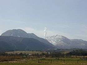
 Mount Kujū from Mount Aso
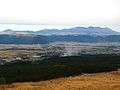
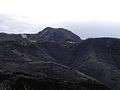 Mount Kujū from Chōjabaru
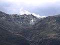 Mount Iō from Chōjabaru
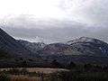 Mount Hōsshō and Mount Iō from Chōjabaru
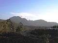 Mount Kujū from Narukogawa Gorge
 Mount Taisen
 Kujū Flower Gardens and Kujū Mountains
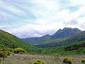 Mount Kujū from Makinoto Pass with Mount Mimata on the right
See also
References
- 1 2 3 "Japan Ultra-Prominences". Peaklist.org. Retrieved 2015-01-01.
External links
| Wikimedia Commons has media related to Mount Kujū. |
- Kujusan - Japan Meteorological Agency (in Japanese)
- "Kujusan: National catalogue of the active volcanoes in Japan" (PDF). - Japan Meteorological Agency
- Kuju - Geological Survey of Japan
- Kujusan: Global Volcanism Program - Smithsonian Institution
| Hokkaidō | |||||||||
|---|---|---|---|---|---|---|---|---|---|
| Tōhoku region Jōshinetsu region |
| ||||||||
| Kantō region | |||||||||
| Chūbu region |
| ||||||||
| Western Japan | |||||||||
| |||||||||
This article is issued from
Wikipedia.
The text is licensed under Creative Commons - Attribution - Sharealike.
Additional terms may apply for the media files.