Jebel Shams
| Jabal Shams | |
|---|---|
| جبل شمس | |
 | |
| Highest point | |
| Elevation |
2,997 to 3,009 m (9,832 to 9872 ft) |
| Prominence |
2,818 m (9,245 ft) [1] Ranked 110th |
| Isolation | 523 kilometres (325 mi) |
| Listing |
Country high point Ultra |
| Coordinates | 23°14′13″N 57°15′50″E / 23.23694°N 57.26389°ECoordinates: 23°14′13″N 57°15′50″E / 23.23694°N 57.26389°E |
| Naming | |
| Translation | Mountain of Sun (Arabic) |
| Geography | |
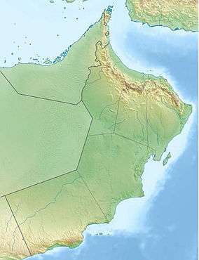 Jabal Shams Location of Jabal Shams in Oman | |
| Location | Oman |
| Parent range | Al Hajar Mountains |
| Climbing | |
| Easiest route | (to South Summit) W4 route published by Ministry or Tourism, Oman (Grade 2 / 3) at Trekking Route 3 |
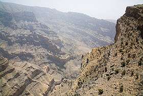
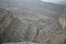
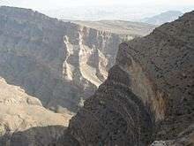
Jebel Shams Arabic: جبل شمس, (mountain of sun) is a mountain located in northeastern Oman north of Al Hamra town. It is the highest mountain of the country and part of Al Hajar Mountains range. It is a popular sightseeing area located 240 km (149 mi) from Muscat. In the summer, temperature is around 20 °C (68 °F) and in the winter it drops to less than 0 °C (32 °F).
Summit
North Summit
The Jebel Shams true highest point is the North Summit, which is occupied by a military base and is a restricted area. The Ministry of Tourism, Sultanate of Oman, states the North Summit to be 3009 m (9872 ft) high.[2]
South Summit
Jebel Shams has a second summit, the South Summit, which is publicly accessible for Trekking via the W4 Trail, marked by the Oman Ministry or Tourism, as published in Trekking Route 3. The elevation of the second south summit is 2997 m (9832 ft).[3]
See also
References
- ↑ "Jabal ash Sham, Oman". Peakbagger.com. This prominence value is based on an elevation of 3,018 m.
- ↑ "Mountains in Oman". website. Ministry of Tourism,Sultanate of Oman.
- ↑ "Trekking". website. Ministry of Tourism,Sultanate of Oman.

External links
- Travel Blog on Jebel Shams
- http://www.enhg.org/field/jshams04/jshams04.htm
- Flickr Images
- https://www.webcitation.org/query?url=http://www.geocities.com/evertinoman/shams.htm&date=2009-10-25+21:57:14
| Wikimedia Commons has media related to Jebel Shams. |