Summersville Lake
| Summersville Dam | |
|---|---|
 Summersville Lake | |
| Location | Nicholas County, near Summersville, West Virginia |
| Coordinates | 38°13′23″N 80°53′26″W / 38.22306°N 80.89056°WCoordinates: 38°13′23″N 80°53′26″W / 38.22306°N 80.89056°W |
| Construction began | 1960 |
| Opening date | 1966 |
| Operator(s) | U.S. Army Corps of Engineers, Huntington District |
| Dam and spillways | |
| Impounds | Gauley River |
| Height | 390 feet (120 m) |
| Length | 2,280 feet (690 m) |
| Reservoir | |
| Creates | Summersville Lake |
| Surface area | 2,700 acres (11 km2) |
| Normal elevation | 1,644 feet (501 m) |
Summersville Lake is a reservoir located in the US state of West Virginia. The lake is formed by a rock-fill dam (Summersville Dam) on the Gauley River, south of Summersville in Nicholas County. It is the largest lake in West Virginia, with 2,700 acres (1,100 ha) of water and over 60 miles (97 km) of shoreline at the summer pool water level. Its maximum depth is 327 feet.
Dam
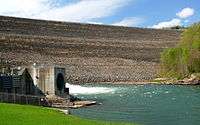
The lake was constructed between 1960 and 1966 by the United States Army Corps of Engineers in order to control flooding in an 803-square-mile (2,080 km2) watershed along the Gauley River and the Kanawha River. At 390 feet (120 m) tall, 2,280 feet (690 m) long, and containing 12,000,000 cubic yards (9,200,000 m3) of dirt and rock, the dam itself is the second-largest rock-fill dam in the Eastern United States. President Lyndon B. Johnson dedicated both the dam and a new Summersville Post Office on September 3, 1966.
The US Corps of Engineers broke a long-standing tradition in naming what was called the Summersville Project. Tradition holds that the project will be named after the town nearest the site of construction, unless named for a person (such as Hoover Dam). However, the town of Summersville was not the one nearest the dam. The village of Gad (located near the present-day marina) was literally flooded at the opening of the reservoir. After briefly considering the name "Gad Dam," it was instead decided to name the project after the next nearest town – Summersville.
Hydroelectric project
In 2001, a two-year project was completed to harness the dam outflow for hydroelectric power generation. The power plant has a capacity to generate 80-megawatts of electricity at peak flow.
Recreation
The lake also serves as a recreation area for fishing, boating, and rock climbing[1], as well as snorkeling and scuba diving. It serves as the eastern (upstream) end of Gauley River National Recreation Area. There is a small boat under the lake that was intentionally sunk to give divers something to view while scuba diving. There is a strict 'no alcohol' policy on boats rented at the marina to prevent any public accidents or indecency while on the river.[2] Beyond the bridge that Route 19 crosses over the lake is a no-wake zone for casual boating.
Gallery
 Summersville Dam
 Aerial view of the lake.
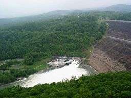
 Spillway and tailwaters
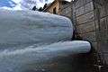 Detail of spillway
References
- ↑ "Summersville Lake - Rock Climbing". RootsRated. Retrieved 2018-08-21.
- ↑ "Pontoon Boats". www.summersvillelakemarina.com. Retrieved 2018-08-21.