Masvingo Province
| Masvingo Province | |
|---|---|
| Province | |
 Great Zimbabwe ruins, found in the province. | |
 Masvingo, Province of Zimbabwe | |
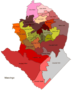 Masvingo constituency seats for the 2008 elections | |
| Country | Zimbabwe |
| Capital | Masvingo |
| Established | late 19th century |
| Government | |
| • Governor | Josiah Dunira Hungwe (ZANU-PF) |
| Area | |
| • Total | 56,566 km2 (21,840 sq mi) |
| Population (2012 census) | |
| • Total | 1,485,090 |
| • Density | 26/km2 (68/sq mi) |
| Time zone | UTC+2 (CET) |
| • Summer (DST) | UTC+2 (CEST) |
Masvingo is a province in southeastern Zimbabwe. It has a population of 1.485 million as of the 2012 census, ranking fifth out of Zimbabwe's ten provinces. Established as Victoria Province by the British South Africa Company, it was one of the five original provinces of Southern Rhodesia. In 1982, two years after Zimbabwean independence, it was renamed Masvingo Province. The Great Zimbabwe national monuments, a world heritage site are located in the northern part of the province near Masvingo City. The province is divided into seven districts, including Masvingo District, which contains the provincial capital MasvingoCity.
Masvingo Province is bordered by Matabeleland South Province to the southwest, Midlands Province to the northwest, Manicaland Province to the northeast, and Mozambique to the southeast. It has an area of 56,566 square kilometres (21,840 sq mi), equal to 14.48% of the total area of Zimbabwe. It is the third-largest in area of Zimbabwe's provinces, after Matabeleland North and Mashonaland West. A diverse province, the Karanga, a Shona subgroup, form the majority, with minorities of Shangani in the southeast and Ndebele in the west. Its economy is largely centered around agriculture and tourism. Masvingo Province is home to the Great Zimbabwe ruins, a World Heritage site and major tourist attraction.
History
The town of Masvingo was founded in 1890 and was the first large settlement to be established by the Pioneer Column of the BSAC which makes it the oldest town in Zimbabwe. It was named Fort Victoria after Queen Victoria.
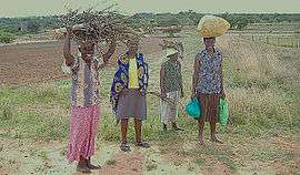
The province is largely populated by members of the Karanga tribe, who are the most populous tribe in Zimbabwe, and are a sub-group of the Shona speaking tribes that also include the Zezuru, Manyika and Ndau. Masvingo province, known before 1982 as Victoria province, is in the drier lowveldt area in the south of Zimbabwe. The boundaries were changed slightly in the 1980s. From white settlement until 2000 most of the area was devoted to cattle ranching, with mining and sugar cane growing (irrigated from Mutirikwi), and communal areas where subsistence farming is carried out. With the land reforms of the early 21st century large scale cattle and mixed farms are being redistributed to small farmers.
Geography
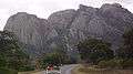
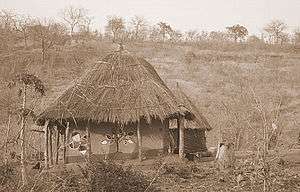
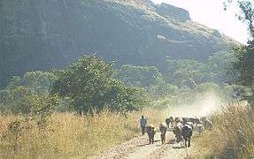
Masvingo (formerly Fort Victoria) is the capital of the province. Chiredzi and Triangle are other major towns in the province. The province is dominated by the Save, Runde, Mwenezi and Limpopo river systems which all either join or drain directly into the Indian Ocean. The only notable mountain range is the Chimanimani Mountain Range in the east. Kopjes, grey and bald in the hot sun, dot the countryside. Mopane trees, drought tolerant and sturdy, are found throughout the province.
Climate
Masvingo province is located in the low veld of the country where rainfall is minimal and uncertain. a large of the southern part of the province is drought prone, set as region 5 in the country's climatic regions. Most parts of the province, therefore, are generally unfit for agriculture, apart from cattle ranching. Masvingo have most of the educated population in Zimbabwe.[1][2][3] Hippo Valley estates in Chiredzi and Triangle use the water from Lake Kyle for irrigation.
Demographics
Despite the aridness, the residents of the province are proud tillers of the earth and like most Bantu tribes in Southern Africa they practise animal husbandry to supplement their diets. In fact, like the rest of the country, their most prized possessions are cattle, which patriarchs demand as lobola, bride-price (dowry), in return for the hand of their daughters in marriage. The status of men in the villages in the province is assessed according to the number of cattle they possess - those with no cattle are not considered men. Cattle owners were dismayed during the drought of 1992 when then 90 percent of the cattle in the province died of famine.[4]
The province has an area of 56,566 km² and a population of approximately 1.3 million (2002). The Karanga form a majority in the province. In Chiredzi District, there are communities of Shangani people while those of the Ndebele are found on the western edge of the province. To the north-east, are found the Ndau. The white population has declined continuously since independence, heightened during the invasions of white commercial farms in 2000. In fact, the first farm invasion occurred in Masvingo Province and the rest of the country followed suit.
Government
The province's leader is a governor appointed by the country's president for a five-year term of office. The province also sends six elected members to the Senate plus a number of chiefs. In addition, twenty six members of parliament, selected from the province's seven districts, are sent to the House of Assembly.
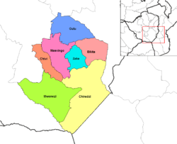
Districts
The districts are run by the rural district councils, which are composed of members elected from the wards in the district. Masvingo is divided into seven administrative districts, although these can be further divided by the delimitation committee during elections depending on population figures. The districts are Bikita, Chivi, Zaka and Masvingo in the center of the province, Gutu in the north, and Mwenezi, and Chiredzi in the south and east respectively. All these seven districts have business centres known as growth points except for Mpandawana (recently granted town status), and they are as follows with estimation of distance from Masvingo city centre: Masvingo- Nemanwa (30 km), Bikita- Nyika (82 km), Zaka- Jerera (96 km), Gutu- Mupandawana (94 km).
Elections
Masvingo was generally regarded as a stronghold of ZANU-PF, the ruling party. In the parliamentary elections of 2005, ZANU-PF won all but one district of the fourteen seats up for grabs.[5] For the election of March, 2008 the seven districts were redistributed into twenty-six constituencies.[6]
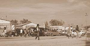
Economy
Tourism is a major contributor to the province's GDP, as is agriculture.
Transportation
The busy A1 highway connects the major centers of Masvingo and Beitbridge.
Tourism
The province has a number of attractions. In the east of the province along the Mozambique border is Gonarezhou National Park, part of the Gaza, Kruger and Gonarezhou Transfrontier National Park concept. Less than an hour away to the east lies the world-famous stone ruins of Great Zimbabwe National Monument, from which Zimbabwe draws its name. A little closer to the stone ruins is Lake Kyle, a huge body of water where people spend time engaged in recreational actives in Mutirikwi Recreational Park. Tourism is a major contributor to the province's GDP, as is agriculture.
Notable people
The province has produced a number of illustrious figures in the history of the country. Famous sons of the province include President Emmerson Mnangagwa who was raised in Chivi, Zimbabwe's first vice-president, nationalist and founding father of Zimbabwe, Simon Muzenda;[7] Harvard trained lawyer, nationalist and politician Edson Zvobgo,Oxford trained Advocate Pearson Nherere (First Blind Advocate in the whole world), Paul Tangi Mhova Mkondo, Nationalist & Businessman, Nationalist Crispen Mandizvidza, ambassador Stan Mudenge and Alois Chidoda; Member Of Parliament Shuvai Mahova; Chief Air-Marshall Josiah Tungamirai; Governor Josiah Hungwe.[8] The popular singer, Paul Matavire, aka Dr. Love was from Mwenezi, while Gen. Vitalis Zvinavashe, the second supreme commander of the Zimbabwe Defence Forces, is from Gutu. The first black President of the Senate in Zimbabwe was the late national hero, Nolan Chipo Makombe, who was born in Zimuto in 1932 and passed on in May 1998. Also from Masvingo province is one of Zimbabwe's first ambassadors, Eleck Mashingaidze from Mberengwa district.
Image gallery


See also
References
- ↑ Millions in need of food aid (accessed 17 February 2008)
- ↑ Experiment success (accessed 17 February 2008)
- ↑ Harsh Times (accessed 17 February 2008)
- ↑ Cattle Ruslting (accessed 17 February 2008)
- ↑ "Results for Parliamentary Elections March 31, 2005". Zimbabwe Election Commission. April 2005. Archived from the original on 31 July 2007.
- ↑ "Mbeki meets Zim's political leaders". BuaNews. 17 January 2008. Archived from the original on 16 July 2011.
- ↑ Shaw, Angus (20 September 2003). "Frail Zimbabwe Vice President Dies at 80". Archived from the original on 12 April 2014.
- ↑ Mangwende, Brian (2 October 2003). "Zimbabwe: Zanu PF Split Over Zvobgo". The Financial Gazette. Harare, Zimbabwe. Archived from the original on 8 October 2003. (accessed 17 February 2008)
External links
- Lake Kyle Recreational Park
- Zimbabwean Online Community