Umzingwane District
| Umzingwane District | |
|---|---|
| administrative district | |
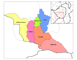 Umzingwane District in Matabeleland South | |
| Coordinates: 20°20′49″S 28°56′59″E / 20.34694°S 28.94972°ECoordinates: 20°20′49″S 28°56′59″E / 20.34694°S 28.94972°E | |
| Country | Zimbabwe |
| Province | Matabeleland South |
| Area[1] | |
| • Total | 2,797 km2 (1,080 sq mi) |
| Elevation[2] | 1,176 m (3,858 ft) |
| Population (2012)[3] | |
| • Total | 62,990 |
| Time zone | UTC+2 (CAT) |
Umzingwane is a district in the northern part of Matabeleland South province in Zimbabwe. It was formerly known as Esigodini District and before 1982 as Essexvale District.[4]
Geography
Umzingwane District adjacent to Bulawayo on the northwest, and on the north to Umguza District of Matabeleland North. Otherwise it is bounded by districts of Matabeleland South, namely Mguza to the north east, Insiza to the east, Gwanda to the south and Matobo to the west. [1]
Places in Umzingwane
- Bushtick, a village
- Bushtick Mine
- Esibomvu, a village
- Esigodini, administrative centre
- Esiphezini, birthplace of Canaan Banana, first president of Zimbabwe[4]
- Inyankuni reservoir
- Kumbuzi, a village
- Lake Cunningham Recreational Park, 41.72 km2[5]
- Matendele, a village
- Mawabeni, a village
- Mzingwane Dam reservoir
- Mzingwane River (Umzingwane River)
- Selous House Homestake, historical site
- Sihlengeni, a village
- Umzingwane Recreational Park, 12 km2[5]
- Upper and Lower Ncema reservoirs
Administration and politics
Umzingwane District is governed by the Umzingwane Rural District Council, which has its offices in Esigodini.[1] Traditionally the district is divided into four parts, each ruled by a local chieftain.
- Esiphezini Communal Land tribal area
- Umzingwane Tribal Trust Land tribal area
- Tuli Outspan Tribal Trust Land tribal area
Economy
In 2012, Umzingwane District had 48 percent of the economically active population employed in agriculture (primarily livestock raising), 17 percent employed in services occupations, 17 percent employed in mining and construction and 2 percent employed in educational institutions.[3]
Notes and references
- 1 2 3 "About". Umzingwane Rural District Council. Archived from the original on 15 October 2017.
- ↑ "Umzingwane District". GeoView.
- 1 2 "Zimbabwe 2012 Census: Provincial Report Matabeleland South" (PDF). ZimStat. Archived (PDF) from the original on 29 March 2017.
- 1 2 Akyeampong, Emmanuel Kwaku; Gates, Henry Louis, Jr., eds. (2012). "Banana, Canaan Sodindo". Dictionary of African Biography. 1. Oxford, England: Oxford University Press. p. 365. ISBN 978-0-19-538207-5.
- 1 2 Heath, Robin A. (1986). "The National Survey of Outdoor Recreation in Zimbabwe" (PDF). Zambezia. 13 (1): 25–42. Archived (PDF) from the original on 6 March 2016.
External links
- Umzingwane District Map (PDF) (Map). United Nations Office for the Coordination of Humanitarian Affairs {OCHA). 4 January 2010.