Mashonaland East Province
| Mashonaland East | |
|---|---|
| Province | |
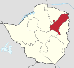 Mashonaland East, Province of Zimbabwe | |
| Country | Zimbabwe |
| Capital | Marondera |
| Area | |
| • Total | 32,230 km2 (12,440 sq mi) |
| Population (2012 census) | |
| • Total | 1,344,955 |
| • Density | 42/km2 (110/sq mi) |

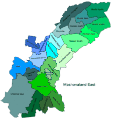
Districts of Mashonaland East
Constituencies
Mashonaland East, informally Mash East, is a province of Zimbabwe. It has an area of 32,230 km² and a population of approximately 1.35 million (2012). Marondera is the capital of the province.
Districts
Mashonaland East is divided into nine districts:
Education
See also
Notes
External links
- "Base map of Mashonaland East Province" (PDF). United Nations Office for the Coordination of Humanitarian Affairs (OCHA). Archived from the original (PDF) on 19 April 2014.
Coordinates: 17°30′S 32°00′E / 17.500°S 32.000°E
This article is issued from
Wikipedia.
The text is licensed under Creative Commons - Attribution - Sharealike.
Additional terms may apply for the media files.