Umguza District
| Umguza District | |
|---|---|
| administrative district | |
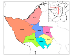 Umguza District in Matabeleland North | |
| Coordinates: 20°04′S 28°35′E / 20.067°S 28.583°ECoordinates: 20°04′S 28°35′E / 20.067°S 28.583°E | |
| Country | Zimbabwe |
| Province | Matabeleland North |
| Area[1] | |
| • Total | 8,374.78 km2 (3,233.52 sq mi) |
| Population (2012)[2] | |
| • Total | 89,687 |
| Time zone | UTC+2 (CAT) |
Umguza is a district in the southern part of Matabeleland North province in Zimbabwe. It was formerly known as Esiphezini District.
Geography
Umguza District is bounded by Matopo and Umzingwane districts in the southeast, Bulilima and Tsholotsho in the west, Kusile (formerly part of Lupane District) in the north and Bubi in the north and east. It surrounds the Bulawayo metropolitan area to the south on three sides.[1]
Places in Umguza
Administration and politics
Umguza District is governed by the Umguza Rural District Council, which has its offices in Bulawayo.[1] The district has one constituency, Umguza constituency, which was created out of the old Bubi-Umguza constituency. The constituency consists of the Nyamandlovu and Sawmills areas divided into fifteen wards.[4]
Obert Moses Mpofu was elected in 1990 and 1995 as the member of parliament from Bubi-Umguza Constituency, the predecessor constituency.[5] In 2008 and in 2013 he filled the parliamentary seat for the Umguza constituency.[5] He did not run in 2018.[6]
Economy
The climate in the district is arid and the primary occupation is animal ranching.[4] Among recent problems are "land barons" establishing illegal settlements, established without any concern for services such as water and electricity.[7]
Notes and references
- 1 2 3 4 "About us". Umguza Rural District Council. Archived from the original on 11 September 2017.
- ↑ "Zimbabwe 2012 Census: Provincial Report Matabeleland North" (PDF). ZimStat. Archived (PDF) from the original on 29 March 2017.
- ↑ Belle, Johannes; Sithabile, Moyo; Ogundejib, Abiodun A. (2017). "Assessing communal farmers'preparedness to drought in the Umguza District, Zimbabwe". International Journal of Disaster Risk Reduction. 22: 194–203. doi:10.1016/j.ijdrr.2017.03.004.
- 1 2 "Umguza Constituency Profile". Parliament of Zimbabwe. Archived from the original on 15 November 2017.
- 1 2 "Obert Mpofu". Pindula. Archived from the original on 20 May 2016.
- ↑ "Obert Mpofu bows out". The Chronicle. 5 April 2018. Archived from the original on 19 June 2018.
- ↑ Tshili, Nqobile (2 February 2018). "Govt intervenes to address Umguza district illegal settlements problem". Chronicle. Archived from the original on 2 February 2018.
External links
- Umguza District Map (PDF) (Map). United Nations Office for the Coordination of Humanitarian Affairs {OCHA). 4 January 2010. Archived (PDF) from the original on 27 July 2018.