Matabeleland South Province
| Matabeleland South | |
|---|---|
| Province | |
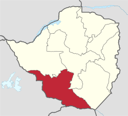 Location of Matabeleland South in Zimbabwe | |
| Country | Zimbabwe |
| Established | 1974 |
| Capital | Gwanda |
| Area | |
| • Total | 54,172 km2 (20,916 sq mi) |
| Population (2012 census) | |
| • Total | 683,893 |
| • Density | 13/km2 (33/sq mi) |
Matabeleland South is a province in southwestern Zimbabwe. With a population of 683,893 as of the 2012 census, it is the country's least populous province. After Matabeleland North, it is Zimbabwe's second-least densely populated province. Matabeleland South was established in 1974, when the original Matabeleland Province was divided into two provinces, the other being Matabeleland North. The province is divided into six districts. Gwanda is the capital, and the Beitbridge is the province's largest town. The name "Matabeleland" is derived from Ndebele, the province's largest ethnic group.
Matabeleland South is bordered by Bulawayo and Matabeleland North to the north, Midlands to the northeast, Masvingo to the southeast, South Africa to the south, and Botswana to the west. It has an area of 54,172 square kilometres (20,916 sq mi), equal to 13.86% of the total area of Zimbabwe. It is the fourth-largest in area of the country's ten provinces. Matabeleland South sits on the edge of the Kalahari Desert, giving it an arid climate not hospitable to agriculture. Its economy is largely centered around subsistence farming and livestock farming. Droughts and a lack of economic opportunities have resulted in widespread poverty and migration out of the province.
Geography
The province sits on the edge of the Kalahari desert, hence it is arid and very dry. The province shares borders with South Africa and Botswana. As a result, there are Tswana, Sotho/Pedi, Venda, Shangani (Tsonga) and the Khoisan speaking people in the province. The other languages that are native in the province are Ndebele and Khalanga.
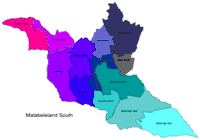
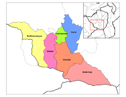
Districts
The province of Matabeleland South is divided into 6 districts:
- Beitbridge
- Bulilima
- Gwanda
- Insiza
- Mangwe
- Matobo
- Umzingwane
Notable villages/towns
- Gwanda
- Beitbridge
- Brunapeg
- Filabusi
- Plumtree
- Tshitshi
Madlambudzi Masendu Ndolwane [Tshankwa/ Sikhathini]]
- Kezi
- Makhado
- Maphisa
- Shangani
- Antelope Mine
- Matobo National Park
- West Nicholson
- Colleen Bawn
- Kafusi
- Esigodini
- Stanmore
- Zezani