Manyuchi Dam
| Lake Manyuchi | |
|---|---|
 Sunrise and dusk looking east | |
| Location | Mwenezi, Masvingo |
| Coordinates | 21°03′14″S 30°22′12″E / 21.054°S 30.370°E |
| Type | reservoir |
| Primary inflows | Mwenezi River, Manyoshi, Mtedzi, Mhondi, Makugwe, Sovoleli, Malole, Mwele, |
| Primary outflows | Mwenezi River |
| Catchment area | Lowveld, Zvishavane, Mberengwa |
| Basin countries | Zimbabwe |
| Surface area | 33 km2 (13 sq mi) |
| Max. depth | 25 m (82 ft) |
| Water volume | 303,473 ML (10,717.0×106 cu ft) |
| Surface elevation | 600 m (2,000 ft) |
| Islands | 17 |
Manyuchi Dam forms a reservoir on the Mwenezi River in southern Zimbabwe. It is located in the Mwenezi District.[1][2] The building of the dam was financed by the Mwenezi Development Corporation. The dam was built to irrigate oil palm estates.[3]
History
The dam was built by International Construction Zimbabwe (ICZ), a division of the southern African construction giant Murray and Roberts, and was completed in 1988.[4] The dam is located in the Mwenwezi River Valley in the middle section of the river. The area is flat and dry and semi-arid with countless dome-shaped mountains and kopjes in which troops of baboons roam at will. When it was built, a number of villages where displaced and forced to relocate by the government to distant places like the area between Ngundu and Chiredzi (District), where they suddenly found themselves labelled illegal settlers by local officials.[5][6]
Physical characteristics
The dam was built in a gorge that the Mwenezi River makes when passing through the mountains close to the bucolic village of Magomana. The area is dominated by mountains and kopjes. It is an arch dam with a gross head that stands at 25 m in height. The water level in the dam reached the spillway crest for the first in 1996.
Ecology
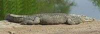
The river once boasted of hippos, but now they are gone. Instead the dam is riven with crocodiles. A number of villagers have lost their lives in the past while fishing in the dam from the Nile Crocodiles.[7] There are several species of fish found in the dam, mostly in the family of tigerfish found in Lake Kariba. The dam's lifespan is under threat from the upstream dwellers, especially those in Mataga and districts in Zvishavane who till in the catchment of the dam producing silt.
Uses
Electricity Generation
Zimbabwe Electricity Supply Authority (ZESA) has long had plans to generate electricity from the dam but nothing has come of it due to shortage of funding. Studies show, however, that the water availability should make it possible to drive two 350-kilowatt turbines 6 000 hours per year, so as to generate 4.2 gigawatthours per year.[4][8]
Irrigation
The Manyuchi dam in Zimbabwe was designed to irrigate an agroindustrial complex (2,000 hectares of sugar cane), 40 km downstream from the dam. The dam is to be used primarily to meet irrigation needs. The local population have tried to start irrigation projects using the water from the dam, but lack of funding has derailed their efforts, especially those in nearby Magomana village.[9] It was built to provide water for irrigation for both the commercial and rural irrigation schemes. To date, only the commercial farmers have benefited. None of the 3,476 hectares which were to have been irrigated for the small farmers has been developed. In 1995, at the height of a severe drought in the district and nationally, the dam was over 80 percent full and benefiting only a few large scale commercial farmers.[10]
Lately there has been talk of Lapache Irrigation Scheme, a project funded by both the government, Triangle Sugar Ltd and a consortium of non-governmental organizations. The scheme represents the first major step towards the utilization of water from the dam to benefit local communities.[11][12] Beneficiaries shall mainly be resettled farmers on the Lapache Farm.
Recreation
Previously tourists used to go there do fishing and other cool activities. But these days, it is difficult to get there, the roads were washed away etc. you would need a four-wheel drive vehicle to access it.
In popular culture

The dam features in local folklore.
See also
Image gallery
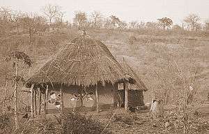 Typical village homestead in communities that live on the edge of the dam
 The national flower along the edges of the dam.
 View around the dam
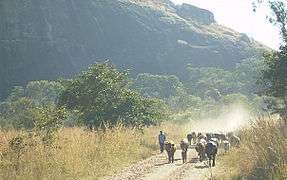 Cattle herding Duty for a boy from nearby Magomana village
References
- ↑ Charles Mbohwa, The Electricity Journal, Volume 15, Issue 7, August–September 2002, Pages 82-91
- ↑ "Mwenezi (District) map showing Manychuchi Dam". Archived from the original on 18 March 2007. Retrieved 21 January 2008.
- ↑ William Wolmer: From Wilderness Vision to Farm Invasions: Conservation & Development in South-East Lowveld, Tsehai Publishers, 2007.
- 1 2 "Assessment of the E7 Group (including EDF) Proposal for a Mini-hydroelectric Power Station in Zimbabwe". Retrieved 2008-01-18.
- ↑ HM Masundire - Wetlands Ecology and Priorities for Conservation in Zimbabwe, 1994
- ↑ The Zimbabwe Independent accessed 21 January 2008
- ↑ Crocodile Attack (assessed 19 February 2008)
- ↑ "Electrification of the Manyuchi Dam" (PDF). Archived from the original (PDF) on 15 July 2011. (299 KiB)
- ↑ Manyanhaire, I.O, Svotwa, E., Sango, I. and Munasirei, D. Journal of Sustainable Development in Africa (Volume 9, No.2, 2007)
- ↑ Ammon Mutembwa,UNIVERSITY OF CAMBRIDGE,Global Security Fellows Initiative,Occasional Paper No. 3: Water and the Potential for Resource Conflicts in Southern Africa, February 1998
- ↑ Lapache Irrigation Scheme construction starts (accessed 19 February 2008)
- ↑ Expansion to cost 500 billion (accessed 19 February 2008)
External links
Coordinates: 21°04′24″S 30°22′56″E / 21.07333°S 30.38222°E