Marble Hill, Manhattan
| Marble Hill | |
|---|---|
| Neighborhood of Manhattan | |
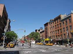
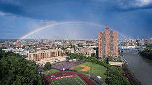 An overview of Marble Hill, seen from the west. The John F. Kennedy Educational Campus can be seen in the foreground, and the rest of the neighborhood is in the center. The Bronx is in the background. | |
| Coordinates: 40°52′34″N 73°54′36″W / 40.876°N 73.91°WCoordinates: 40°52′34″N 73°54′36″W / 40.876°N 73.91°W | |
| Country |
|
| State |
|
| City |
|
| Borough | Manhattan |
| Community District | Bronx 8 [1] |
| Founded | 1891 |
| Named for | Local deposits of dolomite marble quarried for Federal buildings in lower Manhattan when New York was the Capital of the United States in the 1780s. |
| Area[2] | |
| • Total | 0.38 km2 (0.145 sq mi) |
| Population (2010)[2][3] | |
| • Total | 9,481 |
| • Density | 25,000/km2 (65,000/sq mi) |
| Economics[2][3] | |
| • Median income | $44,096 |
| ZIP code | 10463 |
| Area code | 718/347/929, and 917 |
| Website |
www |
Marble Hill is the northernmost neighborhood in the New York City borough of Manhattan. It is the only Manhattan neighborhood that is not on an island. Marble Hill was occupied as a Dutch colonial settlement in 1646, and gained its current name in 1891 because of marble deposits underneath the neighborhood.
Politically a part of Manhattan and New York County, Marble Hill became an island in the Harlem River when it was separated from the island of Manhattan by the construction of the Harlem Ship Canal in 1895. In 1914, the Harlem River was filled in on the north side of Marble Hill, connecting it to the North American mainland and the Bronx. Because of this change in geography, Marble Hill is often associated with the Bronx and is part of two of the latter's Community Board Districts.
History
Colonization
Marble Hill has been occupied since the Dutch colonial period. On August 18, 1646, Governor Willem Kieft, the Dutch Director of New Netherland, signed a land grant to Mattius Jansen van Keulan and Huyck Aertsen. This grant had comprised the whole of the present community. Johannes Verveelen petitioned the Harlem authorities to move his ferry from what is now the East River and 125th Street to Spuyten Duyvil Creek because the creek was shallow enough to wade across, thus providing a means of evading the toll. The ferry charter was granted in 1667. Many settlers circumvented the toll for the ferry by crossing the creek from northern Marble Hill to modern Kingsbridge, Bronx, a point where it was feasible to wade or swim through the waters.[4][5] In 1669 Verveelen transplanted his ferry to the northern tip of Marble Hill, at today's Broadway and West 231st Street.[5][6]
Bridges
Two bridges connected Marble Hill with the mainland: the King's Bridge[7][8][9] and the Dyckman Free Bridge.[5][9] In 1693 Frederick Philipse, a Dutch nobleman who had sworn allegiance to the Crown upon the British takeover of Dutch New Netherlands, built the King's Bridge at Marble Hill near what is now West 230th Street in the Bronx.[7][8][10] Originally a merchant in New Amsterdam, Philipse had purchased vast landholdings in what was then Westchester County.[7][10] Granted the title Lord of Philipse Manor, he established a plantation and provisioning depot for his shipping business upriver on the Hudson in present-day Sleepy Hollow. His toll bridge provided access and opened his land to settlement. Later, it carried the Boston Post Road.[7][8]

In 1758, the Free Bridge was erected by Jacob Dyckman and Benjamin Palmer.[5] It opened on January 1, 1759.[4][11] Its purpose was to serve the farmers who refused to pay the toll.[8] Stagecoach service was later established across the span.[7][10] The new bridge proceeded to take much of the traffic away from the King's Bridge.[4][11]
One of the local visiting spots during this period was a tavern operated by the Dyckman family. They had a tavern called the Black Horse Inn, located just south of McGowan's Pass in what is now East Drive of Central Park, near 102nd Street.[12] The Dyckmans sold the Black Horse to finance a new operation on the west side of Broadway and 226th Street that was to be managed by Benjamin Palmer, who owned property on City Island. It was situated to cater to the traffic from both bridges. In 1772 the Dyckmans sold the tavern to Caleb Hyatt and was known by the new owner’s name as Hyatt’s Tavern at the Free Bridge.[13]
During and after the American Revolution
When hostilities broke out at the start of the American Revolution, the Continental Army constructed a fort on Marble Hill as part of a series of forts to defend the area. By November 1776, the fort had been taken over by Hessian forces and renamed Fort Prince Charles in honor of Charles, Duke of Brunswick, brother-in-law to George III. Despite contrary beliefs, the King's Bridge and the Dyckman Free Bridge served as escape routes for the retreating American forces after the Battle of Fort Washington on November 16, 1776. The latter of these bridges was destroyed during the war.[5] In January 1777, an American attack was made in the Marble Hill area against the Hessian occupiers. This particular raid was under the command of General William Heath, which, when the cannons opened up, forced the Hessians to retreat from the tavern to the fort to return fire.

Hyatt's Tavern remained in the Hyatt family until 1807, when it was leased to James Devoe. The building was eventually razed, succeeded by the Kingsbridge Hotel on the east side of Broadway at 226th Street.[13] The hotel had a mansard roof and a central turret. It catered to the anglers and sportsman who came to the area either by the Hudson River Railroad Company or boat service up the Harlem River. One of the meals served at the hotel was turtle dinner, which became a favorite of the guests. The hotel’s business declined when Broadway was widened and interest was lost in the community. The hotel eventually fell into disrepair and was torn down in 1917.[13]
Philipse Manor was also forfeited to the state legislature after the war. Afterward, the King's Bridge was free.[4][7]
In 1817, Curtis and John Bolton purchased land in the area, laying a road called Bolton Road.[14] Their home was on the south side of the community and had a mill located 350 East of Broadway, which is on property now owned by Metro-North. The Boltons were related to Reginald Bolton, a noted historian of northern Manhattan.
The name of Marble Hill was conceived when Darius C. Crosby came up with the name in 1891 from the 100-to-500-foot-deep (30 to 152 m)[15] deposits of dolomite marble underlying it, a relatively soft rock that crops out in Inwood and Marble Hill, known as Inwood marble.[16] The marble was quarried for the federal buildings in lower Manhattan when New York was the capital of the United States in the 1780s.
Saint Stephen’s United Methodist Church, a community fixture since its 1898 construction, is located at 228th Street and Marble Hill Avenue.[17] It is the third structure of the same name, as well as one of the oldest remaining buildings in Marble Hill. The congregation was founded on Mosholu Parkway in 1826 and was incorporated a decade later, making it one of the earliest religious institutions in the area. It moved to another structure in Riverdale in 1876.[18] The church building was restored in the 1950s, and again in 2010.[17] One of its corners, the one closest to the intersection, has a tall bell tower. There are circular stained glass windows facing both streets. Inside is an Akron Plan-inspired setup with balconies and an auditorium that is laid out like an amphitheater.[17] One of the pastors of St. Stephen's was Reverend William Tieck, who served the church from 1946 to 1977. Tieck was the official Bronx County historian from 1989 to 1996, authoring several books about the Bronx.[8][19]
Separation from Manhattan Island
After an increase in ship traffic in the 1890s, the United States Army Corps of Engineers determined that a wide canal was needed for a shipping route between the Hudson and Harlem rivers. Such a canal had been proposed since the early 19th century.[10][20] In the 1810s, a narrow canal had been dug through the south end of Marble Hill at approximately 222nd Street, known as "Boltons' Canal" or "Dyckman Canal".[21][22][23]
Construction of such a waterway, the Harlem River Ship Channel,[24] finally started in January 1888.[25][26] The canal was to be 400 feet (120 m) in width and had a depth of 15 feet (4.6 m) to 18 feet (5.5 m). It would be cut directly through the rock of Dyckman's Meadow, making a straight course to the Hudson River.[7][25]
The first section of the canal, the cut at Marble Hill, was completed in 1895 and opened on June 17 of that year.[5][27][28] Several festivities including parades were held to commemorate the occasion.[28][29] This rendered Marble Hill an island bounded by the canal to the south and the original course of the Harlem River to the north.[30] The Greater New York Charter of 1897 designated Marble Hill as part of the Borough of Manhattan.
Effective January 1, 1914, by an act of the New York State Legislature Bronx County was created, but Marble Hill remained as part of New York County.[31][32] Later in 1914, the old river was filled in with 51 acres (21 ha) of landfill,[23] physically connecting Marble Hill to the Bronx and the rest of the North American mainland.[33][34] Both the King's and Dyckman Free Bridges were covered over with landfill and replaced by the Broadway Bridge, a bridge over the new Harlem River Ship Canal.[9] At 210 West 230th Street on the southwest corner of Broadway and 230th is a plaque designating the area as the site of the King's Bridge. The site of the Dyckman Free Bridge is located on the grounds of today's Marble Hill Houses.[8]
Character
Housing
Six-story apartment houses were constructed in the 20th century, and in the early 1950s urban renewal came to the area. A complex was built bounded by Broadway, Exterior Street and 225th Street and was called the Marble Hill Houses. This property was acquired by New York City on August 26, 1948. The houses were completed in 1952.[35] Part of the acquisition became the Marble Hill Playground, which is located on Marble Hill Avenue between 228th and 230th Streets.[35] Despite the name, only seven of the 11 towers are actually in Marble Hill; the other four are in Kingsbridge.[23]
Out of Marble Hill's 4,000 households, only 135 lived in private houses as of 1995,[36] down from 138 such households in 1989.[37] The majority of Marble Hill's 9,481 residents (as of the 2010 United States Census)[2][3] live in the Marble Hill Houses.[23] There are also Art Deco apartment buildings lining some streets. These buildings even boast one pedestrian alley, Marble Hill Lane, in a manner similar to in Inwood and surrounding Bronx neighborhoods.[8]
Private residences in Marble Hill include detached single- and two-story houses.[23] It is not uncommon to see a detached house next to a multilevel apartment building in Marble Hill.[8] The neighborhood is described as cozy, with neighbors watching out for one another, and a sense of "community spirit."[23] The blocks of Marble Hill with these single-story houses were described as a "well-kept secret": relatively cheap, with ample space and a backyard.[36] In 1995 one reporter wrote of these houses, "Where else in Manhattan can you find a six-bedroom, three-story house on a quiet, tree-lined street with an attic, a basement, an enclosed front porch and a pretty facade for sale for $174,000? Or a three-family house with six bedrooms on an architecturally magnificent street with an asking price of $295,000?"[36]
Street naming
Many of the neighborhood's streets were named for Dutch settlers to Marble Hill.[8] For instance, Teunissen Place, a dead-end alley off Terrace View Avenue to the neighborhood's west, is named after Tobias Teunissen, a wool washer from Leyden, Holland, who came to the area in 1636.[8] He applied for and received a land grant to live in Inwood near 213th Street. Occasionally he had worked on the De La Montagne farm, which was in what is now the Harlem section of Manhattan.[38]:98 Teunissen was killed in an Indian raid in 1655, and his wife and child were held hostage until they were ransomed by the Dutch authorities.[8] The Dyckmans and the Nagles, who owned land in Inwood, purchased the Teunissen property in 1677.[39]:356
Adrian Avenue is named after Adriaen van der Donck, an early lawyer in New Amsterdam. With permission, he bought a strip of land from local Native American tribes in 1646.[8] This land stretched from Spuyten Duyvil to present-day Yonkers along the Hudson coastline.[8]
Van Corlear Place, which comprises half of a U-shaped street curving around Marble Hill, has detached one- and two-family homes in addition to a few brick townhouses.[8] It was named after Anthony Van Corlaer, a messenger of New Amsterdam Governor-General Peter Stuyvesant who was sent to the mainland Bronx for backup soldiers following reports of attempts by British forces to seize New Amsterdam.[8] In Washington Irving's book A History of New York, van Corlear is said to have drowned while crossing Spuyten Duyvil Creek.[40] The street's name is misspelled.[8]
Jacobus Place, the other half of the U-shape that includes Van Corlear Place, has both a large brick apartment building and freestanding private houses with diverse designs.[8] It is named after Jacob (Jacobus) Dyckman,[8] the owner of the Dyckman Tavern and a sponsor of the Dyckman Free Bridge.[5]
Fort Charles Place remains as a token of the Hessian-named Fort Prince Charles, noted above.[41]
Shopping mall
The River Plaza, a shopping mall located on 40 West 225th Street between Broadway and Exterior Street and overlooking the Harlem River, opened in August 2004. It is the commercial center for Marble Hill.[42] It cost $90 million and has a floor area of 235,000 square feet (21,800 m2). Its original anchors were Target, Marshalls, and Applebee's. The mall, which has an open-air format in which the passageways between stores are outdoors, has a 640-space parking lot on the roof.[42] In 2002, before construction, developers purchased adjacent land from six owners, with the largest building on these lots being a deteriorating, 3 1⁄2-floor, 326,000 square feet (30,300 m2) warehouse owned by NewYork–Presbyterian Hospital. Since the building could not be renovated cheaply enough, it was demolished.[42] The mall was built on a foundation of soft soil and a shallow water table, so builders had to place 1,500 concrete-capped steel piles into the soil.[42] The finished building was designed to retain views of landmarks like the George Washington Bridge and the Empire State Building. The mall's exterior details are reminiscent of the skyline of New York City.[42]
Education
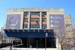
John F. Kennedy High School was built in the former riverbed on the western side of Marble Hill, and was opened in September 1972.[43] Beginning in fall 2002, smaller high schools were established within the campus.[44] Due to poor academic performance in the 2000s, as well as a series of violent crimes at the school (including the murder of a student),[45] the New York City Department of Education made a decision in fall 2010 to close the school, phasing out one grade per year until 2014.[46] It closed down in 2014,[47][48] and six smaller, specialty high schools now occupy its campus: four public, two charter.[49] Four of these schools were founded in 2002, while the other two were established in 2011 after the decision was made to close John F. Kennedy High School.[50]
The nearest elementary school is P.S. 7 in Kingsbridge.[37][51]
Nearby private schools include Horace Mann School, Riverdale Country School, and Ethical Culture Fieldston School. Nearby parochial schools are Good Shepherd, in Inwood, and St. John's and Visitation, in Kingsbridge.[23]
The Marble Hill Nursery School, in the Marble Hill Houses, is privately operated with some funding with the city.[23]
Transportation
In 1905–1906, the New York Central and Hudson River Railroad built the Marble Hill station as a replacement for the former Kingsbridge Station used by an affiliate known as the Spuyten Duyvil and Port Morris Railroad.[52] The station was relocated from the east side of Broadway to the west side in the late-1970s and is now served by the Metro-North Railroad's Hudson Line, which provides commuter railroad service to Grand Central Terminal in midtown Manhattan, locations in the Bronx, and points north.[53] The station is at the bottom of a substantial cliff.[8]
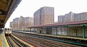
The Interborough Rapid Transit Company (IRT) extended their Broadway–Seventh Avenue line, now part of the New York City Subway, from 145th Street to 242nd Street in 1906.[54] As part of the construction, the IRT built a station at 225th Street.[54] That station is currently served by the 1 train.[55]
The main street through Marble Hill is Broadway, part of U.S. Route 9.[37]
Political status
The United States Census Bureau defines Marble Hill as Census Tract 309 of New York County. As of the 2010 census, it had a population of 8,463 on a land area of 0.3065 km² (0.1183 sq mi, 75.7 acres).[56] Because Marble Hill is legally part of Manhattan, residents who serve on jury duty go to the courthouses at Foley Square in lower Manhattan.[57] Marble Hill is represented by the offices of City Council District 10 Manhattan as well as elected officials in both Manhattan and the Bronx. Bronx Community Board 8 oversees the day-to-day operations of Marble Hill.
History of political dispute
On March 11, 1939, as a publicity stunt, Bronx Borough President James J. Lyons planted the Bronx County flag on the rocky promontory at 225th Street and Jacobus Place. Lyons proclaimed Marble Hill as a part of the Bronx and demanded the subservience of its residents to that borough, saying it was "The Bronx Sudetenland," referring to Hitler’s 1938 annexation of a region of Czechoslovakia. The incident was met with boos and nose-thumbing by 50 residents of Marble Hill.[58] Since then, more lighthearted "annexations" have occurred.[59]
Residents of the neighborhood wished to remain residents of Manhattan, and petitions and signatures were gathered to be sent to Governor Herbert H. Lehman to ensure that Marble Hill remain part of Manhattan.[36] In 1984, in response to one Marble Hill resident's refusal to serve on jury duty for a murder case in Manhattan that year,[57] the matter was settled when the New York Legislature passed legislation declaring the neighborhood part of Manhattan.[36][60] The confusion was so great that when New York City Councilman Guillermo Linares was elected as Marble Hill's representative in 1991, he originally thought the neighborhood was part of the Bronx.[36]
Services
Marble Hill residents remain part of a political district that includes the northernmost areas of Manhattan (Washington Heights and Inwood), but city services – for example, the fire and police departments – come from and are in the Bronx for reasons of convenience and safety, since the only road connection to the rest of Manhattan is a lift bridge, the Broadway Bridge.[23][61] However, medical services are provided from Manhattan Island, and medical vehicles come from Columbia University's Allen Pavilion, also known as the Allen Hospital, a satellite facility of NewYork-Presbyterian Hospital.[23]
The United States Postal Service assigned Marble Hill and Spuyten Duyvil the ZIP code 10463 – the "104" prefix is used for Bronx localities, while "100" through "102" are reserved for Manhattan addresses[61][lower-alpha 1] – although mail can be addressed to either "New York, New York" using the USPS designator for Manhattan, or to "Bronx, New York" as long as the ZIP code is accurate.
In 1984, area code 718 was created out of area code 212 for the boroughs of Brooklyn, Queens, and Staten Island; in 1992, the Bronx and Marble Hill were added. Marble Hill residents fought to retain the more prestigious 212 area code but lost.[36] This was mainly because New York Telephone persuaded officials that, since Marble Hill's trunk line is wired into the Bronx's line, it would have cost too much to rewire it. Marble Hill, unlike the rest of Manhattan, is in area code 718 (now also served by three overlay codes: 347 and 929 for the outer boroughs, and 917 for the entire city), but residents are listed in both Bronx and Manhattan telephone books.[61]
Notes and references
Notes
- ↑ See also List of ZIP code prefixes
References
- ↑ "NYC Planning | Community Profiles". communityprofiles.planning.nyc.gov. New York City Department of City Planning. Retrieved 6 June 2018.
- 1 2 3 4 "Marble Hill neighborhood in New York". Retrieved June 4, 2014.
- 1 2 3 "Marble Hill" on the Point2Homes website
- 1 2 3 4 Stephen Jenkins (1912). The Story of the Bronx from the Purchase Made by the Dutch from the Indians in 1639 to the Present Day. G. P. Putnam's Sons. pp. 177–208. Retrieved January 2, 2017.
- 1 2 3 4 5 6 7
- "Inwood Hill Park: Spuyten Duyvil Creek". New York City Department of Parks and Recreation. Retrieved January 2, 2017.
- "Final Supplemental Environmental Impact Statement for the Croton Water Treatment Plant at the Harlem River Site; 7.12: Historic and Archaeological Resources" (PDF). New York City Department of Environmental Protection. June 30, 2004. Retrieved January 2, 2017.
- ↑ "Tibbett Gardens: Phase 1A Archaeologial Assessment Report" (PDF). New York City Landmarks Preservation Commission, Historical Perspectives. January 30, 1987. Retrieved January 2, 2017.
- 1 2 3 4 5 6 7 "Final Supplemental Environmental Impact Statement for the Croton Water Treatment Plant at the Harlem River Site; 7.12: Historic and Archaeological Resources" (PDF). New York City Department of Environmental Protection. June 30, 2004. Retrieved January 2, 2017.
- 1 2 3 4 5 6 7 8 9 10 11 12 13 14 15 16 17 18 19 "Marble Hill — Forgotten New York". forgotten-ny.com. Retrieved December 21, 2016.
- 1 2 3 "BRIDGES PROCLAIM MIGHT OF NEW YORK; Metropolis Has Forty-four Spans, Each Making a Contribution to the Life of Its Millions -- Now The Great Structure Over the Hudson River Is Destined to Dwarf All the Others". The New York Times. 1926-12-26. ISSN 0362-4331. Retrieved 2018-06-03.
- 1 2 3 4 Sergey Kadinsky (March 7, 2016). Hidden Waters of New York City: A History and Guide to 101 Forgotten Lakes, Ponds, Creeks, and Streams in the Five Boroughs. Countryman Press. pp. 58–59, 247–249. ISBN 978-1-58157-566-8. Retrieved January 2, 2017.
- 1 2 James Thomas Flexner (January 1992). States Dyckman: American Loyalist. Fordham University Press. pp. 12–15. ISBN 978-0-8232-1369-6. Retrieved January 2, 2017.
- ↑ Hall, Edward H. McGown's Pass and Vicinity. 1905.
- 1 2 3 "Hyatt's Tavern". My Inwood. July 22, 2009. Retrieved January 4, 2017.
- ↑ Assembly, New York (State) Legislature (January 1, 1903). Documents of the Assembly of the State of New York.
- ↑ "The Manhattan Skyline: Why are there no tall skyscrapers between Midtown and Downtown?". blog.epa.gov. Retrieved January 4, 2017.
- ↑ "Tuckahoe Marble". academic.brooklyn.cuny.edu. Retrieved January 4, 2017.
- 1 2 3 Wisnieski, Adam (October 27, 2010). "St. Stephen's new face rejuvenates old faith". The Riverdale Press. Retrieved January 3, 2017.
- ↑ "St. Stephen United Methodist Church - The Bronx, New York". www.nycago.org. Retrieved 2017-01-04.
- ↑ Thomas, Robert Mcg. Jr. (January 20, 1997). "Dr. William A. Tieck, Minister And a Bronx Historian, 89". The New York Times. Retrieved January 3, 2017.
- ↑ Eldredge & Horenstein 2014, p. 104.
- ↑ Eldredge & Horenstein 2014, p. 102.
- ↑ "Survey of Harlem River From Randall's Island, By Way of Spuyten Duyvil Creek, To Hudson River, New York". Annual Report of the Chief of Engineers to the Secretary of War For The Year 1875. Washington, D.C.: Government Printing Office: 224–237. February 18, 1875. Retrieved January 2, 2017.
- 1 2 3 4 5 6 7 8 9 10 Jackson, Nancy Beth (January 26, 2003). "If You're Thinking of Living In/Marble Hill; Tiny Slice of Manhattan on the Mainland". The New York Times. Retrieved January 2, 2017.
- ↑ Eldredge & Horenstein 2014, p. 104–105.
- 1 2 Eldredge & Horenstein 2014, p. 103–105.
- ↑ Harlem River Ship Canal: Letters from Simon Stevens to the Commissioners of the Sinking Fund of the City of New York. C. G. Burgoyne, printer. March 8, 1892. Retrieved January 2, 2017.
- ↑ Eldredge & Horenstein 2014, p. 102–105.
- 1 2 "Harlem Canal Parades" (PDF). The New York Times. June 17, 1895. Retrieved January 3, 2017.
- ↑ "Parades Along The Canal: The Details for Harlem's Festal Day Have Been Completed" (PDF). The New York Times. June 16, 1895. Retrieved January 3, 2017.
- ↑ "What's in a Name: While Marble Hill's Origins Are Clear, Its Present Status is Up for Debate". NY1. Retrieved June 18, 2015.
- ↑ Thorne, Kathryn; Ford, Compiler (1993). Long, John H., ed. New York Atlas of Historical County Boundaries. Simon & Schuster. pp. 33, 118–133. ISBN 0-13-051962-6.
- ↑ New York. Laws of New York. 1912, 135th Session, Chapter 548, Section 1. p.1352.
- ↑ Eldredge & Horenstein 2014, p. 105.
- ↑ Tax Block & Tax Lot Base Map Files on CD-ROM Archived August 5, 2007, at the Wayback Machine., New York City Department of City Planning. Accessed July 26, 2007. "Marble Hill is a neighborhood that is part of the borough of Manhattan but is administratively often included with neighboring areas of the Bronx. Parts of Marble Hill are within Bronx Community District 7; the rest is within Bronx Community District 8."
- 1 2 "Marble Hill Playground Highlights : NYC Parks". New York City Department of Parks & Recreation. Retrieved January 3, 2017.
- 1 2 3 4 5 6 7 Bloom, Jennifer Kingson (July 23, 1995). "If Your Thinking of Living In/Marble Hill; A Bit of Manhattan in the Bronx". The New York Times. Retrieved January 3, 2017.
- 1 2 3 Goetz, Robert F. (February 19, 1989). "If You're Thinking of Living In: Marble Hill". The New York Times. Retrieved January 16, 2010.
- ↑ Wissler, Clark (January 1, 1909). The Indians of Greater New York and the Lower Hudson. The Trustees.
- ↑ Rider, Fremont; Cooper, Frederic Taber; Hopkins, Mary Alden (January 1, 1916). Rider's New York City and Vicinity, Including Newark, Yonkers and Jersey City: A Guide-book for Travelers, with 16 Maps and 18 Plans, Comp. and. H. Holt.
- ↑ Irving, Washington (July 29, 2004) [1809]. "X". A History of New York (eBook). Project Gutenberg. VII. Chicago: W. B. Conkey. OCLC 8381780. Retrieved March 24, 2011.
- ↑ Hooked on the Bronx, Legally Manhattan’s
- 1 2 3 4 5 Hughes, C.J. (September 15, 2004). "Target Gives New Look to the Bronx". The New York Times. Retrieved January 3, 2017.
- ↑ Buder, Leonard (September 11, 1972). "Schools Opening Today With Force of Security Aides". The New York Times. Retrieved December 31, 2016.
- ↑
- "Sharing Space: Rethinking the Implementation of Small High School Reform in New York City" (PDF). New York City Council. August 2005. Retrieved December 31, 2016.
- Kurgan, Laura (November 2005). "From Large School Buildings to Small School Campuses: Orchestrating the Shift" (PDF). New Visions for Public Schools. Retrieved December 31, 2016.
- ↑ Dowling, Nikki (December 8, 2010). "City wants to phase out John F. Kennedy High School". Riverdale Press. Retrieved 31 December 2016.
- ↑
- "Educational Impact Statement: The Proposed Phase-out of John F. Kennedy High School (10X475)" (PDF). New York City Department of Education. December 20, 2010. Retrieved December 31, 2016.
- Feeney, Michael; Colangelo, Lisa; Kolodner, Meredith (December 6, 2010). "JFK High School one of 12 to close". NY Daily News. Retrieved January 3, 2017.
- Dowling, Nikki (December 8, 2010). "City wants to phase out John F. Kennedy High School". Riverdale Press. Retrieved December 31, 2016.
- ↑ Feeney, Michael; Colangelo, Lisa; Kolodner, Meredith (December 6, 2010). "JFK High School one of 12 to close". NY Daily News. Retrieved January 3, 2017.
- ↑ Rajamani, Maya (June 26, 2014). "Brawl breaks out at JFK's last graduation". Riverdale Press. Retrieved December 31, 2016.
- ↑ "2016 New York City High School Directory" (PDF). schools.nyc.gov. New York City Department of Education. 2015. Retrieved 4 June 2015.
- ↑ See:
- Bronx Engineering and Technology Academy: "Bronx Engineering and Technology Academy". New York City Department of Education. Retrieved April 21, 2012.
- Bronx School of Law and Finance: "Bronx School of Law and Finance". New York City Department of Education. Retrieved April 21, 2012.
- Bronx Theatre High School: "Bronx Theatre High School". New York City Department of Education. Retrieved April 21, 2012.
- Marble Hill High School for International Studies: "Marble Hill High School for International Studies". New York City Department of Education. Retrieved April 21, 2012.
- New Visions Charter High School for Advanced Math and Science: "New Visions Charter High School for Advanced Math and Science".
- New Visions Charter High School for the Humanities: "New Visions Charter High School for the Humanities".
- ↑ "Welcome — Milton Fein School — X007 - New York City Department of Education". schools.nyc.gov. Retrieved January 3, 2017.
- ↑ Senate, New York (State). Legislature. (1907). Documents of the Senate of the State of New York. p. 112. Retrieved January 3, 2017.
- ↑ "Metro-North Railroad Map" (PDF). Metropolitan Transportation Authority. Retrieved January 3, 2017.
- 1 2
- "Our First Subway Completed At Last — Opening of the Van Cortlandt Extension Finishes System Begun in 1900 — The Job Cost $60,000,000 — A Twenty-Mile Ride from Brooklyn to 242d Street for a Nickel Is Possible Now". New York Times. August 2, 1908. p. 10. Retrieved November 6, 2016.
- "Annual report. 1908/09-1919/20". HathiTrust. Interborough Rapid Transit Company. Retrieved September 6, 2016.
- ↑ "Subway Map" (PDF). Metropolitan Transportation Authority. January 18, 2018. Retrieved January 18, 2018.
- ↑ Census Tract 309, New York County, New York, United States Census Bureau, accessed June 8, 2006
- 1 2 "Marble Hill: Feet in Manhattan, Heart in the Bronx". WNYC. Retrieved January 4, 2017.
- ↑ "Bronx Borough President Invades Marble Hill, 1939". The New York Times. March 12, 1939. Retrieved January 4, 2017 – via DocumentCloud.
- ↑ Slattery, Denis (2014-05-07). "Marble Hill still caught between two boroughs". NY Daily News. Retrieved 2017-01-04.
- ↑ "Bill Would Clarify Marble Hill's Status". The New York Times. June 27, 1984. ISSN 0362-4331. Retrieved January 4, 2017.
- 1 2 3 Behrend, David W. (March 13, 1995). "It looks like the Bronx – but votes like Manhattan". Columbia University. Retrieved January 4, 2017.
Bibliography
- Eldredge, Niles & Horenstein, Sidney (2014). Concrete Jungle: New York City and Our Last Best Hope for a Sustainable Future. Berkeley, California: University of California Press. ISBN 978-0-520-27015-2.
External links
| Wikimedia Commons has media related to Marble Hill, Manhattan. |
- "Marble Hill" on Washington Heights and Inwood Online web site
- Official website created by the City of New York
| Lower Manhattan below 14th St (CB 1, 2, 3) |
|   |
|---|---|---|
| Midtown (CB 5) | ||
| West Side (CB 4, 7) | ||
| East Side (CB 6, 8) | ||
| Upper Manhattan above 110th St (CB 9, 10, 11, 12) | ||
| Islands |
| |
| Former | ||