Mosholu Parkway
| |
|---|---|
 Map of the Bronx with Mosholu Parkway highlighted in red | |
| Route information | |
| Maintained by NYCDOT | |
| Length | 3.03 mi[1] (4.88 km) |
| Restrictions | No commercial vehicles |
| Major junctions | |
| South end | Bronx Park East in Bronx Park |
|
| |
| North end |
|
| Location | |
| Counties | Bronx |
| Highway system | |

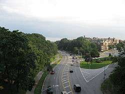
The Mosholu Parkway is a hybrid freeway-standard parkway and grade-level roadway in the New York City borough of the Bronx, constructed from 1935 to 1937 as part of the roadway network created under Robert Moses. The roadway extends for 3.0 miles (4.8 km) between the New York Botanical Garden (where its southeast end meets the Bronx River Parkway) and Van Cortlandt Park (where its northwest end meets the Henry Hudson Parkway). The New York City Department of Transportation is responsible for the operation and maintenance of the roadway while the New York City Department of Parks and Recreation is responsible for the surrounding rights-of-way. The parkway is designated as New York State Route 908F (NY 908F), an unsigned reference route, by the New York State Department of Transportation.
Route description
The Mosholu Parkway begins at exit 8E of the Bronx River Parkway. It heads northward as an arterial boulevard through the northern parts of the Bronx. The highway crosses through Bedford Park, passing Bainbridge Avenue. It intersects with the Grand Concourse afterwards, with Jerome Avenue, Sedgwick Avenue and West Gun Hill Road soon after. Within Van Cortlandt Park, the parkway becomes a limited-access freeway, with exits for the southbound Major Deegan Expressway (Interstate 87) and the Henry Hudson Parkway near its northern terminus at the Westchester County line (where it turns into the Saw Mill River Parkway).[2]
A bikeway, part of the East Coast Greenway, runs along the northeast side of the parkway from Bronx Park to Van Cortlandt Park, connecting through the park to other trails and playing fields and to Broadway.[2]
History
"Mosholu" is an Algonquin word meaning "smooth stones" or "small stones", and was first applied to the nearby creek now known as Tibbetts Brook. The southern end of the parkway was once home to another creek, running under what is now Middlebrook Road, which supplied water to a British fort located on old Van Cortlandt Avenue East during the American Revolutionary War.[3]
The original Mosholu Parkway was constructed pursuant to the New Parks Act of 1884 to link two parks also recommended by that act, Van Cortlandt Park and Bronx Park.[4] The road was reconstructed between 1935 and 1937.[5]
Major intersections
The entire route is in the New York City borough of the Bronx. All exits are unnumbered.
| Location | mi[1][6] | km | Destinations | Notes | |
|---|---|---|---|---|---|
| Bronx Park | 0.00 | 0.00 | Bronx Park East / Allerton Avenue | Northern terminus of Southern Boulevard; southern terminus of NY 908F | |
| 0.03– 0.40 | 0.048– 0.64 | Exit 8 on Bronx River Parkway | |||
| 0.53 | 0.85 | Southern Boulevard south – Fordham Road, Botanical Garden | NY 908F transitions between Southern Boulevard and Mosholu Parkway | ||
| Bedford Park–Norwood line | 1.38 | 2.22 | Grand Concourse south | No northbound access to Grand Concourse | |
| 1.50 | 2.41 | Jerome Avenue – Lehman College | |||
| 1.70 | 2.74 | Modified traffic circle | |||
| 1.80 | 2.90 | Gun Hill Road | |||
| Southern terminus of limited-access section | |||||
| Van Cortlandt Park | 1.90 | 3.06 | Goulden Avenue | Southbound exit and northbound entrance | |
| 2.30 | 3.70 | Southbound exit and northbound entrance; exit 12 on I-87 | |||
| 3.20 | 5.15 | Northbound exit and southbound entrance | |||
| 3.50 | 5.63 | Exit 24 on Henry Hudson Parkway | |||
1.000 mi = 1.609 km; 1.000 km = 0.621 mi
| |||||
See also
- Bedford Park, Bronx, the neighborhood on the southern side of Mosholu Parkway.
- Norwood, Bronx, the neighborhood on the northern side of Mosholu Parkway.
References
- 1 2 "2007 Traffic Data Report for New York State" (PDF). New York State Department of Transportation. July 25, 2008. Archived from the original (PDF) on June 12, 2012. Retrieved May 29, 2009.
- 1 2
- ↑ "Mosholu Parkway". New York City Department of Parks and Recreation. March 9, 2001. Retrieved April 2, 2010.
- ↑ "The City of New York, Department of Parks, Annual Report, 1914" (PDF). p. 161-163. Retrieved 9 August 2018.
- ↑ "Draft Final Report Van Cortlandt Park Pedestrian Bridge Feasibility Study" (PDF). p. 1-2. Retrieved 9 August 2018.
- ↑ Google (January 5, 2016). "Mosholu Parkway" (Map). Google Maps. Google. Retrieved January 5, 2016.
External links
| Wikimedia Commons has media related to Mosholu Parkway. |
- Mosholu Parkway at
- Mosholu Parkway page at nycroads.com