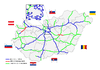
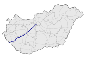
M7 motorway (Hungary)
| |
|---|---|
| M7 autópálya | |
 | |
| Route information | |
|
Part of | |
| Length | 233 km (145 mi) |
| Major junctions | |
| From | Budapest |
|
| |
| To |
Letenye |
| Location | |
| Counties | Pest, Fejér, Veszprém, Somogy, Zala |
| Major cities | Budapest, Érd, Székesfehérvár, Siófok, Nagykanizsa |
| Highway system | |
_Otszogletu_kek_tabla.svg.png)
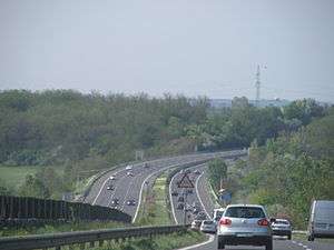
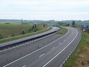
The M7 motorway (Hungarian: M7-es autópálya) is a Hungarian motorway which runs from Budapest towards the Croatian border at Letenye, reaching Székesfehérvár, then Siófok, a town on Lake Balaton, and the city of Nagykanizsa in the southwest of the country.
The motorway connects with the Croatian motorway A4 at Goričan and forms part of the Pan-European corridor Vb, connecting Budapest with Zagreb, the capital of Croatia, and Rijeka, the largest Croatian seaport. Since the completion of the M7 it is possible to travel on motorway from Budapest to the Adriatic Sea, a popular tourist destination for Hungarians.
The last portion of the motorway to the Croatian border, including the Zrinski Bridge on the river Mura, was completed on 22 October 2008. The road's first sections were built in the 1960s and 1970s. The completion of the last sections was undertaken since 2001.
Municipalities
The M7 motorway runs through the following municipalities:
- Budapest, Budaörs, Törökbálint, Érd, Tárnok
- Tordas, Martonvásár, Kajászó, Baracska, Kápolnásnyék, Pázmánd, Velence, Sukoró, Pákozd, Székesfehérvár, Szabadbattyán, Kőszárhegy, Polgárdi, Füle, Lepsény
- Balatonfőkajár
- Balatonvilágos, Siófok, Zamárdi, Balatonendréd, Szántód, Kőröshegy, Balatonszárszó, Szólád, Balatonőszöd, Balatonszemes, Balatonlelle, Balatonboglár, Ordacsehi, Lengyeltóti, Fonyód, Buzsák, Táska, Balatonfenyves, Balatonkeresztúr, Balatonújlak, Balatonszentgyörgy, Hollád, Tikos, Szegerdő, Sávoly, Szőkedencs
- Zalakomár, Galambok, Zalaszentjakab, Nagyrécse, Nagykanizsa, Sormás, Eszteregnye, Rigyác, Petrivente, Becsehely, Letenye
Openings timeline
- Budapest – Budaörs (7 km): 1964 - half profile; (this section was extended 2x3 lane in 1978-79)
- Budaörs – Martonvásár (18 km): 1966 - half profile; (this section was extended in 1972; 2x3 lane in 2001)
- Martonvásár – Velence (15 km): 1967 - half profile; (this section was extended in 1973; 2x3 lane in 2001)
- Martonvásár – Székesfehérvár (12 km): 1968 - half profile; (this section was extended in 1973; 2x3 lane in 2001)
- Székesfehérvár – Balatonaliga (33 km): 1970 - half profile; (this section was extended in 1975)
- Balatonaliga – Zamárdi (22 km): 1971 - half profile; (this section was extended in 2001)
- Zamárdi – Balatonkeresztúr with Kőröshegy Viaduct (14,2 km): 2007.08.08.
- Balatonszárszó – Ordacsehi (20 km): 2005.06.
- Ordacsehi – Balatonkeresztúr (25,7 km): 2006.03.27.
- Balatonkeresztúr – Zalakomár (21 km): 2008.06.26.
- Zalakomár – Nagykanizsa (15 km): 2008.08.19.
- Nagykanizsa – Sormás (11,3 km): 2007.08.24.
- Sormás (Eszteregnye) – Becsehely (4,5 km): 2006.12.11.
- Becsehely – Letenye (6,5 km): 2004.09.18.
- Letenye (

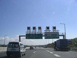
Junctions, exits and rest area
- Distance from Zero Kilometre Stone (Adam Clark Square) in Budapest in kilometres.
| Budapest – Letenye (229 km) | ||||
| 6 km | Budapest, Budaörsi út | The M1 motorway starts with the M7 | ||
| Bp.-Őrmező | ||||
| 7 km | Budaörs | |||
| 10 km | Budaörsi rest area | 81101 | ||
| Budaörs east | ||||
| 11 km | Budaörs west | 8105 | ||
| 12 km | Tatabánya, Győr, Mosonmagyaróvár | M1 turns toward -> | ||
| 14 km | Törökbálint | |||
| 16 km | Hegyeshalom / Pécs, Röszke, Nyíregyháza Budapest International Airport | Budapest bypass | ||
| 18 km | Érd | 8103 | ||
| 19 km | Érdi rest area |
|||
| 23 km | Tárnok / Sóskút, Pusztazámor | 8107 | Regionális Hulladékkezelő Központ | |
| 26 km | Tárnoki rest area | |||
| 30 km | Martonvásár / Gyúró | 81108 | ||
| 33 km | Váli-völgyi rest area | 8111 | ||
| Baracska / Vál | ||||
| 42 km | Kápolnásnyék, Velence / Pázmánd, Lovasberény | 8117 | ||
| 45 km | Velencei rest area | 8119 | ||
| Velence / Nadap, Tata | ||||
| 50 km | Pákozd / Sukoró | 8116 | ||
| Pákozdi rest area | ||||
| 57 km | Székesfehérvár east / Gárdony-Agárd | |||
| 60 km | Székesfehérvár south / Dunaújváros | |||
| Fehérvári rest area | ||||
| 64 km | Székesfehérvár-centrum, Szentgotthárd / Sárbogárd, Szekszárd | Székesfehérvár west bypass | ||
| 70 km | Szabadbattyán / Tác-Gorsium | 6307 | ||
| Gorsium rest area | ||||
| 80 km | Lepsény / Polgárdi | |||
| 83 km | Lepsényi rest area | |||
| 90 km | Balatonfüred / Enying | |||
| 95 km | Sóstói rest area | |||
| 98 km | Siófok east | |||
| 101 km | Szabadi rest area | |||
| Sió Channel | ||||
| 105 km | Siófok-centrum / Szekszárd | |||
| 109 km | Töreki rest area | |||
| 112 km | Siófok west / Zamárdi-felső, Szántód | |||
| 115 km | Balatonendréd / Zamárdi-alsó | 6501 | ||
| 121 km | Balatonföldvár / Bálványos | 6505 | ||
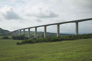
| 121-22 km | Kőröshegy Viaduct | Longest Bridge in Hungary - 1872 m | ||
| 126 km | Balatonszárszó | |||
| 130 km | Balatonőszöd / Szólád | 6524 | ||
| 135 km | Balatonszemes, Balatonlelle / Kaposvár | |||
| 138 km | Balatonlellei rest area | |||
| 143 km | Balatonboglár / Lengyeltóti | 6711 | ||
| 145 km | Ordacsehi | 67101 | ||
| 150 km | Fonyód | 6701 | ||
| 156 km | Táskai rest area | |||
| 160 km | Balatonfenyves | |||
| 168 km | Keresztúri rest area | |||
| 170 km | Balatonszentgyörgy / Kéthely, Marcali | |||
| 175 km | Hollád | 7501 | ||
| 177 km | Szegerdői rest area | |||
| 183 km | Sávoly | |||
| 191 km | Zalakomár, Zalakaros | |||
| 194 km | Zalakomári rest area | |||
| 206 km | Nagykanizsa east / Kaposvár | Nagykanizsa east bypass | ||
| 211 km | Nagykanizsa-centrum, Gyékényes / Zalaegerszeg | |||
| 215 km | Sormási rest area | |||
| 219 km | Sormás / Eszteregnye | |||
| 224 km | Becsehely | 7536 | ||
| 232 km | Letenye, Tornyiszentmiklós | M70 turns toward -> | ||
| 233 km | Letenye (H) – Goričan (HR) border crossing | |||
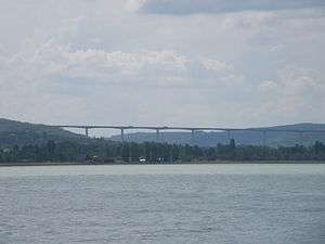
| Mura River | Zrínyi Bridge - 216 m | |||
Toll
From February 1, 2015, the motorway can be used instead of the national sticker with the following county stickers:
| Type of vignette | Available section |
|---|---|
| Pest County | between Egér Street junction and Martonvásár (7 km – 30 km) |
| Fejér County | between Pusztazámor and Balatonvilágos (23 km – 90 km) |
| Veszprém County | between Polgárdi and Siófok east (80 km – 98 km) |
| Somogy County | between Balatonvilágos and Zalakomár (90 km – 191 km) |
| Zala County | between Sávoly and Letenye [state border] (183 km – 234 km) |
Toll-free section
- From Border of Budapest to Egér Street section (5 km – 7 km) can be used free of charge.
Significant artifacts
From Budapest to the Croatian border, the M7 motorway features the following bridges, tunnels or covered cuts:
- Bridge
- Zrinski Bridge (Zrínyi Miklós híd; 216 m or 709 ft) over Mur river
- Viaduct
- Köröshegy Viaduct (Kőröshegyi völgyhíd; 1,872 m or 6,142 ft) – Longest bridge in Hungary
European Routes
| Name | Route | |
| 217 km | ||
| 22 km | ||
See also
External links
| Wikimedia Commons has media related to Autópálya M7. |
- National Toll Payment Services Plc. (in Hungarian, some information also in English)
- National Infrastructure Developer Ltd. (in Hungarian)
- Exit list of M7 in motorways-exitlists.com