Sárbogárd
| Sárbogárd | ||
|---|---|---|
| Town | ||
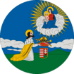
 Sárhatvan Chapel of Sárbogárd | ||
| ||
 Sárbogárd Location of Sárbogárd | ||
| Coordinates: 46°53′16″N 18°37′10″E / 46.88776°N 18.61932°ECoordinates: 46°53′16″N 18°37′10″E / 46.88776°N 18.61932°E | ||
| Country |
| |
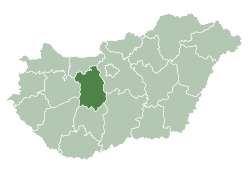
| County | Fejér | |
| District | Sárbogárd | |
| Area | ||
| • Total | 189.34 km2 (73.10 sq mi) | |
| Population (2009) | ||
| • Total | 12,922 | |
| • Density | 70.94/km2 (183.7/sq mi) | |
| Time zone | UTC+1 (CET) | |
| • Summer (DST) | UTC+2 (CEST) | |
| Postal code | 7000 | |
| Area code | (+36) 25 | |
| Website |
www | |

Sárbogárd (German: Bochart) is a town in Fejér county, Hungary. The town is at the intersection of important railroad routes in Hungary: this is where electrified routes from Balaton and Pécs merge with non-electrifed railways from Baja and Szekszárd. A double electrified track runs from Sárbogárd to Budapest allowing MÁV trains to provide quick access to the capital.
Twin towns — sister cities
Sárbogárd is twinned with:


Notable people
- Zoltán Lengyel (1960- ), Hungarian politician
- Géza Mészöly (1844–1887; born in Sárbogárd), Hungarian Romantic painter
- Lajos Májer (1956–1998; born in Sárbogárd), Hungarian footballer
- Béla Jurcsek (1893 – 1945), Hungarian politician, Minister of Agriculture
- Gábor Varga (1968- ), Hungarian politician
Gallery
 The map of Sárbogárd from the First Military Mapping Survey of Austria Empire.
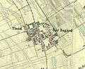 The map of Sárbogárd from the Second Military Mapping Survey of Austria Empire.
 The map of Sárbogárd from the 3rd Military Mapping Survey of Austria Empire.
External links
| Wikimedia Commons has media related to Sárbogárd. |
- Official website in Hungarian
| Town (1) |
| |
|---|---|---|
| Large village (1) | ||
| Villages (10) | ||
| Cities with county rights |
|   |
|---|---|---|
| Towns | ||
| Large villages | ||
| Villages |
| |
| Other topics |
| |
This article is issued from
Wikipedia.
The text is licensed under Creative Commons - Attribution - Sharealike.
Additional terms may apply for the media files.