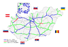
M5 motorway (Hungary)
| |
|---|---|
| M5 autópálya | |
 | |
| Route information | |
|
Part of | |
| Length | 173 km (107 mi) |
| Major junctions | |
| From | Budapest |
|
| |
| To |
Röszke |
| Location | |
| Counties | Pest, Bács-Kiskun, Csongrád |
| Major cities | Budapest, Kecskemét, Kiskunfélegyháza, Szeged |
| Highway system | |
_Otszogletu_kek_tabla.svg.png)

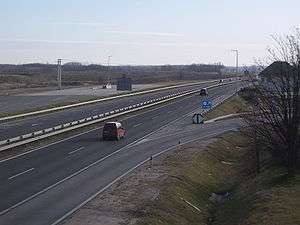
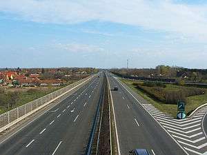
The M5 motorway (Hungarian: M5-ös autópálya) is a Hungarian motorway which connects Budapest with the south-eastern regions of the country, the cities of Kecskemét, Szeged, and finally Röszke on the Serbian border. The motorway reached the city of Szeged in December 2005, while the remaining portion (between Szeged and Röszke) was completed in April 2006.
The M5 continues as the A1 motorway in Serbia from the Serbian side of the border at Horgoš. It is also the main route from Budapest to Bucharest via the M43 motorway and Romania's A1 motorway, as the link has been opened to traffic since July 2015.
Municipalities
The M5 motorway runs through the following municipalities:
Openings timeline
- Budapest – Ócsa (30 km): 1985.11.22.
- Ócsa – Örkény (23 km): 1985.11.22. - half profile; (this section was extended in 1986 and 1990)
- Örkény – Kecskemét-north (30 km): 1989 - half profile; (this section was extended in 1996)
- Kecskemét-north – Kecskemét-south (16 km): 1997.12.06.
- Kecskemét-south – Kiskunfélegyháza (19 km): 1998.06.09.
- Kiskunfélegyháza – Szeged; M43 (51 km): 2005.12.10.
- Szeged; M43 – Röszke (

Junctions, exits and rest area
- Distance from Zero Kilometre Stone (Adam Clark Square) in Budapest in kilometres.
| Budapest – Röszke (173 km) | ||||
| 11 km | Budapest-Kispest | |||
| 13 km | Bp.-Soroksár | |||
| 15 km | Bevásárlóközpontok (Shopping Centers) | |||
| 16 km | M0 connection | Part of old bypass of Budapest | ||
| 22 km | Gyál / Alsónémedi | 4602 | ||
| 23 km | Hegyeshalom, Letenye, Pécs / Nyíregyháza Budapest International Airport | Budapest bypass | ||
| 30 km | Üllő / Ócsa | 4603 | ||
| 35 km | Inárcsi rest area | |||
| Inárcs | ||||
| 44 km | Dabas / Albertirsa | 4606 |
||
| 53 km | Örkény / Albertirsa | 4607 | Geographical centre of Hungary | |
| 54 km | Örkényi rest area | |||
| 67 km | Lajosmizse rest area | 4608 | ||
| Lajosmizse | ||||
| 74 km | Kecskemét north | |||
| 81 km | Kecskemét north bypass | |||
| 85 km | Kecskemét west / Dunaföldvár | |||
| 91 km | Kecskemét south / Sükösd, Baja | |||
| Kecskeméti rest area | ||||
| 102 km | Kunszállás | 5401 | ||
| 109 km | Kiskunfélegyháza north | 5302 | ||
| 114 km | Kiskunfélegyháza south | 5402 | ||
| 122 km | Petőfiszállási rest area | |||
| 129 km | Csengelei rest area | |||
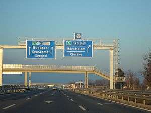
| 140 km | Kistelek | 5411 | ||
| 147 km | Balástya | 5422 | ||
| 151 km | Szatmazi rest area | |||
| 159 km | Szeged, Makó, Csanádpalota | M43 turns toward -> | ||
| 166 km | Szeged west / Domaszék | |||
| 173 km | Röszkei rest area | 5512 |
||
| Szeged south, Röszke | ||||
| 174 km | Röszke (H) – Horgoš (SRB) border crossing | |||
Toll
From February 1, 2015, the motorway can be used instead of the national sticker with the following county stickers:
| Type of vignette | Available section |
|---|---|
| Pest County | between Bevásárlóközpontok junction and Lajosmizse (14 km – 67 km) |
| Bács-Kiskun County | between Örkény and Kistelek (53 km – 140 km) |
| Csongrád County | between Kiskunfélegyháza south and Röszke [state border] (114 km – 174 km) |
Toll-free section
- The collection and distribution circuits leading to Megapark-Tesco, Soroksár-Pestszentlőrinc-Nagybani market and Auchan shopping malls are free of charge (Bevásárlóközpontok junction).
European Route(s)
| Name | Route | |
| 151 km | ||
See also
External links
| Wikimedia Commons has media related to Autópálya M5. |
- National Toll Payment Services Plc. (in Hungarian, some information also in English)
- National Infrastructure Developer Ltd. (in Hungarian)
- Exit list of M5 in motorways-exitlists.com