M70 expressway (Hungary)
 | |
| Route information | |
|---|---|
|
Part of | |
| Length | 21 km (13 mi) |
| Major junctions | |
| From |
|
| To |
Tornyiszentmiklós |
| Location | |
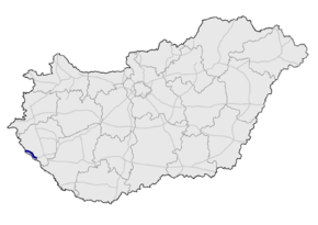
| Counties | Zala |
| Highway system | |
The M70 expressway (Hungarian: M70-es autóút) is an expressway in Hungary, connecting the M7 motorway to the A5 motorway in Slovenia. The last section was completed in 2006. After the opening of the last missing sections of the M7 on August 19, 2008, there is a direct motorway link from Budapest to Slovenia.
Municipalities
The M70 expressway runs through the following municipalities:
Openings timeline
- Letenye; M7 – Tornyiszentmiklós (18.6 km): 2004.11. - half profile
- Tornyiszentmiklós – (

Junctions, exits and rest area
| M70 (Letenye) – Tornyiszentmiklós (21 km) | ||||
| 0 km | Budapest / Letenye | M7 | ||
| 1 km | Korongi Bridge | Bridge - 115,60 m | ||
| 2 km | Letenye / border | |||
| 11 km | Csörnyeföld, Murarátka / Muraszemenye | 7538 | ||
| 15 km | Csörnyeföldi rest area | |||
| Krka River | ||||
| 18 km | Tornyiszentmiklós, Lenti | 7538 | ||
| 20 km | Tornyisztnmiklósi rest area | |||
| 21 km | Tornyiszentmiklós (H) – Pince (SLO) border crossing | |||
Toll
From February 1, 2015, the M70 expressway is fully charged. The motorway can be used instead of the national sticker with the following county stickers:
| Type of vignette | Available section |
|---|---|
| Zala County | full length (0 km – 21 km) |
European Route(s)
| Name | Route | |
| 21 km | ||
See also
External links
| Wikimedia Commons has media related to Autópálya M70. |
- National Toll Payment Services Plc. (in Hungarian, some information also in English)
- National Infrastructure Developer Ltd. (in Hungarian)
- Exit list of M70 in motorways-exitlists.com
| Motorways |  | |
|---|---|---|
| Expressways | ||
This article is issued from
Wikipedia.
The text is licensed under Creative Commons - Attribution - Sharealike.
Additional terms may apply for the media files.