Kőszárhegy
| Kőszárhegy | |
|---|---|
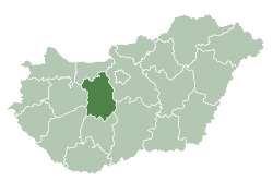
 Kőszárhegy Location of Kőszárhegy | |
| Coordinates: 47°05′27″N 18°20′26″E / 47.09072°N 18.34057°ECoordinates: 47°05′27″N 18°20′26″E / 47.09072°N 18.34057°E | |
| Country |
|
| County | Fejér |
| Area | |
| • Total | 5.9 km2 (2.3 sq mi) |
| Population (2004) | |
| • Total | 1,467 |
| • Density | 248.64/km2 (644.0/sq mi) |
| Time zone | UTC+1 (CET) |
| • Summer (DST) | UTC+2 (CEST) |
| Postal code | 8152 |
| Area code(s) | 22 |
| Motorways | M7 |
| Distance from Budapest | 75.4 km (46.9 mi) Northeast |
| Website |
www |
External links
- Street map (in Hungarian)
| Cities with county rights |
|   |
|---|---|---|
| Towns | ||
| Large villages | ||
| Villages |
| |
| Other topics |
| |
This article is issued from
Wikipedia.
The text is licensed under Creative Commons - Attribution - Sharealike.
Additional terms may apply for the media files.