M1 motorway (Hungary)
| |
|---|---|
| M1 autópálya | |
 | |
| Route information | |
|
Part of | |
| Length | 171 km (106 mi) |
| Major junctions | |
| From | Budapest |
|
| |
| To |
Hegyeshalom |
| Location | |
| Counties | Pest, Fejér, Komárom-Esztergom, Győr-Moson-Sopron |
| Major cities | Budapest, Tatabánya, Tata, Győr, Mosonmagyaróvár |
| Highway system | |
_Otszogletu_kek_tabla.svg.png)

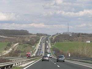
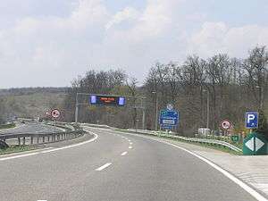


The M1 motorway (Hungarian: M1-es autópálya) is a toll motorway in northwestern Hungary, connecting Budapest to Győr and Vienna. The first section of the motorway opened in the 1970s, reaching the Austrian border at Hegyeshalom in 1996. It follows the route of the old Route 1 one-lane highway.
Municipalities
The M1 motorway runs through the following municipalities:
- Budapest, Budaörs, Törökbálint, Biatorbágy, Páty, Herceghalom
- Mány, Bicske, Óbarok, Nagyegyháza
- Tatabánya, Vértesszőlős, Tata, Kocs, Mocsa, Kisigmánd, Ács
- Nagyszentjános, Győr, Bőny, Töltéstava, Győrújbarát, Abda, Ikrény, Börcs, Mosonszentmiklós, Lébény, Károlyháza, Mosonmagyaróvár, Levél, Hegyeshalom
Openings timeline
- Budapest – Budaörs (7 and 12 km): 1964 - half profile; (this section was extended 2x3 lane in 1978-79)
- Budaörs – Budakeszi (4 km): 1981 - half profile; (this section was extended in 1986)
- Budakeszi – Zsámbék (9 km): 1986
- Zsámbék – Bicske (13 km): 1985
- Bicske – Tatabánya-north (28 km): 1982
- Tatabánya-north – Komárom (20 km): 1975 - half profile; (this section was extended 2x2 lane in 1990)
- Komárom – Győr-east (19 km): 1977 - half profile; (this section was extended 2x2 lane in 1990)
- Győr-east – Győr-Ménfőcsanak (8 km): 1994
- Győr-Ménfőcsanak – Győr-west (14 km): 1994
- Győr-west – Hegyeshalom (

Junctions, exits and rest area
- Distance from Zero Kilometre Stone (Adam Clark Square) in Budapest in kilometres.
| Budapest – Hegyeshalom (171 km) | ||||
| 5 km | Budapest, Budaörsi út | The M1 motorway starts with the M7 | ||
| Bp.-Őrmező | ||||
| 7 km | Budaörs | |||
| 10 km | Budaörsi rest area | 81101 | ||
| Budaörs-east | ||||
| 11 km | Budaörs-west | 8105 | ||
| 12 km | Székesfehérvár, BALATON, Nagykanizsa → to Zagreb | M7 turns toward -> | ||
| 14 km | Törökbálint / Budakeszi | 8102 | Premier Outlet Center | |
| 16 km | Letenye, Pécs, Röszke, Nyíregyháza Budapest International Airport | Budapest bypass | ||
| 17 km | Biatorbágy | |||
| 22 km | Sasfészek-tó rest area | |||
| Biatorbágy / Páty | ||||
| 27 km | Zsámbék / Herceghalom | |||
| 28 km | Zsámbéki rest area | |||
| 39 km | Bicske, Óbarok | |||
| 45 km | Óbarok rest area | 8101 | ||
| Óbarok-Nagyegyháza | ||||
| 54 km | Harkályos rest area | |||
| 56 km | Tatabánya-Óváros | |||
| 57 km | Turul rest area | |||
| 61 km | Tatabánya-Centrum / Vértesszőlős | |||
| 64 km | Tata | |||
| Remeteségi rest area | ||||
| 67 km | Tata / Környe | 8119 | ||
| 72 km | Liget rest area | |||
| 83 km | Laczházy rest area | |||
| 85 km | Komárom / Kisbér | |||
| 94 km | Concó rest area | 8152 | ||
| Bábolna / Ács | ||||
| 101 km | Nagyszentjános / Bőny | 8152 | ||
| 107 km | Győr-east | Access route of Győr | ||
| 112 km | Győrszentiván | 8136 | Győr east bypass, Audi factory | |
| 115 km | Győr-Industrial area / Székesfehérvár | |||
| 119 km | Győr-Szabadhegy / Veszprém, Balatonfüred | |||
| Arrabona rest area | ||||
| 123 km | Győr-Ménfőcsanak / Pápa | |||
| 124 km | Rába River | |||
| 127 km | Railway Line 8 (Győr-Sopron) | |||
| 129 km | Győr-west / Csorna, Sopron – Szombathely | M85 turns toward -> | ||
| 135 km | Börcs rest area | |||
| 142 km | Lébény / Ásványráró | 8417 | ||
| 144 km | Lébény rest area | |||
| 150 km | Hanság rest area | |||
| 158 km | Lajta rest area | |||
| 160 km | Mosonmagyaróvár / Szombathely, Rédics | |||
| 162 km | Mosoni rest area | |||
| 166 km | Rajka | M15 turns toward -> | ||
| 168 km | Hegyeshalom-east | 101 | ||
| Railway Line 16 (Hegyeshalom-Szombathely) | ||||
| 171 km | Hegyeshalom | 10528 | ||
| Hegyeshalom (H) – Nickelsdorf (A) border crossing | ||||
Toll
From February 1, 2015, the motorway can be used instead of the national sticker with the following county stickers:
| Type of vignette | Available section |
|---|---|
| Pest County | between Egér Street junction and Bicske (7 km – 39 km) |
| Fejér County | between Herceghalom and Tatabánya-Óváros (27 km – 56 km) |
| Komárom-Esztergom County | between Bicske and Győrszentiván (39 km – 112 km) |
| Győr-Moson-Sopron County | between Bábolna and Hegyeshalom [state border] (94 km – 172 km) |
Toll-free section
- From Border of Budapest to Egér Street section (5 km – 7 km) can be used free of charge.
European Route(s)
| Name | Route | |
| 155 km | ||
| 150 km | ||
| 6 km | ||
See also
External links
| Wikimedia Commons has media related to Autópálya M1. |
- National Toll Payment Services Plc. (in Hungarian, some information also in English)
- National Infrastructure Developer Ltd. (in Hungarian)
- Exit list of M1 in motorways-exitlists.com
This article is issued from
Wikipedia.
The text is licensed under Creative Commons - Attribution - Sharealike.
Additional terms may apply for the media files.