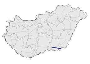
M43 motorway (Hungary)
| |
|---|---|
| M43 autópálya | |
 | |
| Route information | |
|
Part of | |
| Length | 57.7 km (35.9 mi) |
| Major junctions | |
| From |
|
| To |
Csanádpalota |
| Location | |
| Counties | Csongrád |
| Major cities | Szeged, Makó |
| Highway system | |
_Otszogletu_kek_tabla.svg.png)
The M43 motorway (Hungarian: M43-as autópálya) is a Hungarian motorway that runs from the junction with the M5 Motorway west of Szeged to the Romanian border at Nagylak via Makó. Since 2015 it connects Hungary with Romania as the first border crossing on a motorway between the two countries.
Municipalities
The M43 motorway runs through the following municipalities:
Openings timeline
- 1: Szeged; M5 – Szeged-north (3 km): 2005.12.10.
- 2/A: Szeged-north – Szeged-Sándorfalva (4.4 km): 2010.04.01.
- 2/B: Szeged-Sándorfalva – Szeged-Hódmezővásárhely (3.3 km): 2010.10.07.
- 2/C: Szeged-Hódmezővásárhely – Makó (23.9 km): 2011.04.09.
- 3: Makó – Csanádpalota (

Junctions, exits and rest area
| M5 (Szeged) – Csanádpalota (57.7 km) | ||||
| 0 km | Budapest / Röszke | M5 turns toward -> Budapest or | ||
| 2 km | Railway Line 140 (Cegléd-Szeged) | |||
| 4 km | Szeged-Rókus / Kistelek | |||
| 5 km | Szegedi rest area | |||
| 8 km | Szeged-north / Sándorfalva | 4519 | ||
| 9 km | Railway Line 135 (Szeged-Békéscsaba) | |||
| 11 km | Szeged-Felsőváros / Hódmezővásárhely | |||
| 16 km | Tisza River | Ferenc Móra Bridge - 661 m | ||
| 19 km | Rákóczi telep | 4413 | ||
| 24 km | Maroslele | 4414 | ||
| 31 km | Kéthalmi rest area | project | ||
| 35 km | Makó / Hódmezővásárhely | 430 | ||
| 35 km | Railway Line 130 (Szolnok-Makó) | |||
| 46 km | Apátfalva, Kövegy / Királyhegyes | 4425 | ||
| 51 km | under construction | |||
| 55 km | Nagylak / Csanádpalota, Tótkomlós | 4451 | ||
| 55 km | Railway Line 121 (Békéscsaba-Újszeged) | |||
| 57 km | Krak-éri rest area | Temporary border crossing | ||
| 59 km | Csanádpalota (H) – Nădlac (RO) border crossing | |||
Toll
From February 1, 2016, the M43 motorway is fully charged. The motorway can be used instead of the national sticker with the following county stickers:
| Type of vignette | Available section |
|---|---|
| Csongrád County | full length (0 km – 57 km) |
Significant artifacts
- Bridge
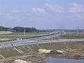
- Ferenc Móra Bridge (Móra Ferenc híd; 661 m or 2,169 ft) over Tisza river
European Route(s)
| Name | Route | |
| 59 km | ||
Gallery
 M43 motorway near Szeged
 M43 motorway near Kiskundorozsma
 M43 motorway near Szeged
 Móra Ferenc bridge over Tisza river
See also
External links
| Wikimedia Commons has media related to Autópálya M43. |
- National Toll Payment Services Plc. (in Hungarian, some information also in English)
- National Infrastructure Developer Ltd. (in Hungarian)
- Exit list of M43 in motorways-exitlists.com
| Motorways |  | |
|---|---|---|
| Expressways | ||
This article is issued from
Wikipedia.
The text is licensed under Creative Commons - Attribution - Sharealike.
Additional terms may apply for the media files.