M60 motorway (Hungary)
| |
|---|---|
| M60 autópálya | |
 | |
| Route information | |
| Length |
30.2 km (18.8 mi) 56 km (35 mi) planned |
| Major junctions | |
| From |
|
| To |
Barcs |
| Location | |
| Counties | Baranya |
| Major cities | Pécs, Szigetvár |
| Highway system | |
_Otszogletu_kek_tabla.svg.png)
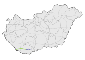
The M60 motorway (Hungarian: M60-as autópálya) is 56 km long. It begins at the Bóly interchange on the M6 and ends at the Croatian border at Barcs, continuing on in Croatia as the A13 motorway. It connects Pécs with Zagreb.
Municipalities
The M60 motorway runs through the following municipalities:
Openings timeline
Junctions, exits and rest area
| M60 (BÓLY - BARCS) | |||
| Exit | km | Note | |
|---|---|---|---|
| 0 km | The M6 turns toward Budapest or -> | ||
| Szajki pihenőhely (rest area) | 3 km | ||
| 6 km | |||
| 25 km | |||
| 30 km | |||
See also
External links
| Wikimedia Commons has media related to Autópálya M60. |
- National Toll Payment Services Plc. (in Hungarian, some information also in English)
- National Infrastructure Developer Ltd. (in Hungarian)
- Exit list of M60 in motorways-exitlists.com
| Motorways |  | |
|---|---|---|
| Expressways | ||
This article is issued from
Wikipedia.
The text is licensed under Creative Commons - Attribution - Sharealike.
Additional terms may apply for the media files.