Archway, London
| Archway | |
|---|---|
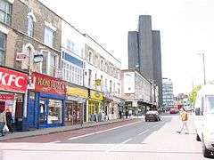 One of five approaches to the centre of the district at Archway Tower, next to which is its station on the Northern Line | |
 Archway Archway shown within Greater London | |
| OS grid reference | TQ285875 |
| • Charing Cross | 4 mi (6.4 km) N |
| London borough | |
| Ceremonial county | Greater London |
| Region | |
| Country | England |
| Sovereign state | United Kingdom |
| Post town | LONDON |
| Postcode district | N19 |
| Dialling code | 020 |
| Police | Metropolitan |
| Fire | London |
| Ambulance | London |
| EU Parliament | London |
| UK Parliament | |
| London Assembly | |
Archway is an inner city area in the London Borough of Islington, London. The district is mainly urban and apart from its south-central main streets and towers is a mixed-density residential neighbourhood with three small parks and bordering two larger parks. Its focus is 3.8 miles (6 km) north of Charing Cross. Straddling the A1 in London which is in the northern rise of the area in cutting, crossed by a high, single-arch bridge, it has a modern commercial hub around Vantage Point (formerly Archway Tower) and Archway tube station.[1][2]
Archway adjoins Waterlow Park in Highgate and Holloway, Islington below to the south. Its east and west borders are expensive, garden-lined residential areas adjoining Crouch Hill and the Dartmouth Park area of Highgate. In its west Whittington Hospital occupies a large site.
A legend perpetuated by the name of the hospital and a statue on the older street leading, beside the hospital, to Highgate records Dick Whittington, medieval Mayor of London failing to make his fortune in the city heard the Bow Bells (those of St Mary-le-Bow, a church on Cheapside) from here, a distance of 4.5 miles (7.2 km) leading to the later homage "turn again Whittington, thrice Lord Mayor of London", inscribed on the supporting stone protected by railings. On top of the thick tablet, his cat of English folklore is cast in stone.
History
The name refers to the Hornsey Lane Bridge carrying the minor road from Crouch End, Hornsey, over the cutting of Archway Road. The original, brick-built, multi-arched bridge of 1813 was replaced in 1896 by the current cast-iron one.[3] A few residents, especially those born and locally raised in the early 20th century, refer to the area with a definite article (as "the Archway") which shows the derivation of the name from the bridge.
Seven bus routes in London terminate at 'Archway', the term having become mainstream after the tube station, originally called Highgate, was renamed Highgate (Archway) in 1939, and subsequently Archway (Highgate) in 1941, and Archway in 1947.
The ecclesiastical parishs (once having had poor-relief vestries employing highwaymen, for example) before the laws that disestablished their secular components do not mention Archway. Those covering the area are parts of traditional parent parishes named Whitehall Park, Upper Holloway, St John the Evangelist, Upper Holloway and a very small part of a Highgate, Islington parish.[4]
The Archway Road is part of the A1 or Great North Road, one of the original toll roads. From 1813 to 1864, the cutting contained a toll gate, where travellers paid for the next stage of their journey, as is recorded by a plaque at 1 Pauntley Street, an apartment block.[5]
A restored 1821 memorial stone topped with a small statue of Whittington's Cat is known as the Whittington Stone and is next to a pub of the same name on Highgate Hill, a street in Archway.[6] The memorial marks the legendary site where 'Dick Whittington' Sir Richard's folkloric alter ego, returning home discouraged after a disastrous attempt to make his fortune in the City, heard the bells of St Mary le Bow ring out, 'Turn again Whittington, thrice Lord Mayor of London.'[6] Seeing the building of a maternity hospital and drains for the poor of London during his lifetime, he left his wealth to a broad-based charity which continues into the 21st century.[7]
Highgate Hill, the road from Archway to Highgate village, was the route of the first motorised cable car in Europe. It operated from 1884 to 1909.
Pauntley Street takes its name from the village of Pauntley in the Forest of Dean, Gloucestershire, traditionally regarded as Dick Whittington's birthplace.[8]
There has been a large Irish community in the area since the 1830s, before the mass migration of the Great Famine. Many of them worked in building railways and roads and became known as navigators. After the Second World War, the Irish community formed in the area continued to grow as the newly-opened Whittington Hospital recruited nurses from Ireland. Although immigration slowed as the country became more prosperous, the Irish influence on the area can still be seen in pubs such as The Mother Red Cap and The Floirin, the supply of Irish newspapers in local newsagents and the naming of the pedestrian precinct as Navigator Square, after the Irish navigators who built many of the roads in the area.[9][10]
Amenities
Civic
- Hospital
The Whittington hospital on the south-west side of Highgate Hill (a street) has many buildings and specialisations, taking up a large minority of the west of the area. It is named after Sir Richard Whittington (Dick Whittington).
- Parks, Sports Grounds and Parkland Walk
Including its western green buffers has nine parks within a mile of the tube station (five of which are in Archway): Archway Park, Hillrise Park, Dartmouth Park, Elthorne Park, Sunnyside Gardens, Crouch Hill Park, Waterlow Park, Whittington Park, Foxham Gardens, and Tufnell Park Playing Fields, two of which are large. Parkland Walk or New Orleans Walk describes also a neighbourhood, equidistant between Crouch End and Archway (in Inner London places are defined by proximity to rail or tube station). Green spaces exist between facing blocks of the residential mid rise estates: Girdlestone Walk, Henfield Close and Cardinals Way, varying proportions of which remain social housing.
Commercial
The south side of a former five-way roundabout block gives Archway an open area — Archway market place — and Archway's characteristic high-rise focus. Here a tall, slender commercial and residential tower, Vantage Point, next to the tube station, forms the highest structure in Archway. This piazza area is 500 metres south-east of the A1 cutting, built in the late 2010s and directly faces the tube station.
The Archway Tavern the pub facing the market place/piazza has weekly music concerts, is where the photograph for the cover of The Kinks' 1971 album Muswell Hillbillies was taken.
The Winchester, a pub at 206 Archway Road, is on the Campaign for Real Ale's National Inventory of Historic Pub Interiors.[11](Note: It is not in Archway N19, Islington but in Highgate, N6, Haringey.) It was built in 1881 as the Winchester Tavern, and it later became the Winchester Hall Hotel. The name derives from Winchester Hall, a nearby late 17th-century mansion.[11]
Notable current and former residents
Transport
The nearest London Underground station is Archway tube station on the Northern line. The nearest London Overground station is Upper Holloway.
Neighbouring districts and places. | |
|---|---|
See also
References
- ↑ The Highgate Archway from the Turnpike gate at Holloway
- ↑ The Highgate Archway, with London and St Paul's Cathedral in the Distance 1813
- ↑ T F T Baker; C R Elrington, eds. (1980). Hornsey, including Highgate - Communications | A History of the County of Middlesex: Volume 6. Victoria County History. pp. 103–107). Retrieved 2 December 2012.
- ↑ In which parishes does Archway lie - searchable map. The Church of England. Retrieved 2015-03-06.
- ↑ Plaques of London http://www.plaquesoflondon.co.uk/page61.html
- 1 2 Historic England. "Whittington Stone along Highgate Hill, c. 15 m south of junction with Magadala Avenue (1298038)". National Heritage List for England.
- ↑ [http://www.mercers.co.uk/charitable-trusts Charitable Trusts Worshipful Company of Mercers
- ↑ Daily Mail: Road to riches http://www.dailymail.co.uk/travel/article-2076060/Dick-Whittingtons-road-riches-Following-footsteps-Gloucestershire-London.html
- ↑ Finch, Emily (8 December 2017). "Navigator Square – built on the pluck of the Irish". Camden New Journal. London. Retrieved 17 March 2018.
- ↑ Morris, James (15 December 2017). "'Everyone wants us to move': Archway Market plans Navigator Square relocation". Islington Gazette. London. Retrieved 17 March 2018.
- 1 2 Brandwood, Geoff (2013). Britain's best real heritage pubs. St. Albans: CAMRA. p. 89. ISBN 9781852493042.
| Districts |  | |
|---|---|---|
| Attractions |
| |
| Street markets | ||
| Parks and open spaces |
| |
| Constituencies | ||
| Tube and rail stations | ||
| Other topics | ||