Finsbury Park (area)
| Finsbury Park | |
|---|---|
 | |
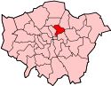
 Finsbury Park Finsbury Park shown within Greater London | |
| Population | 14,358 (2011 Census - partial)[1][2] |
| OS grid reference | TQ314872 |
| London borough | |
| Ceremonial county | Greater London |
| Region | |
| Country | England |
| Sovereign state | United Kingdom |
| Post town | LONDON |
| Postcode district | N4 |
| Dialling code | 020 |
| Police | Metropolitan |
| Fire | London |
| Ambulance | London |
| EU Parliament | London |
| UK Parliament | |
| London Assembly | |
Finsbury Park is an area towards the northern edge of Inner London, England, which grew up around an important railway interchange near the convergence of the Boroughs of Islington, Haringey and Hackney.
Geography
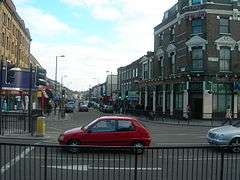
The area is centred on Finsbury Park station, a major bus, rail and tube interchange near the southern end of the 46-hectare (110-acre) public park of the same name.
The neighbourhood includes part of Finsbury Park and Highbury West wards within the London Borough of Islington[3], part of Brownswood ward in the London Borough of Hackney[4], part of Stroud Green Ward and a very small part of Harringay ward in the London Borough of Haringey.[5]
Locale
The area is distinctly cosmopolitan and urban, as reflected by the variety of shops and establishments on Seven Sisters Road, Blackstock Road and Stroud Green Road. The North London Central Mosque (also known as the Finsbury Park Mosque), which drew attention for extremist activity before a change in leadership in 2003, is located here. Arsenal Football Club's Emirates Stadium is nearby.
Demographics
Finsbury Park has a significant immigrant population with a lower level of residents born in the UK than the national average and a higher rate of residents either born in other EU countries or outside the EU.[2][6] Immigrant groups include a small Irish community.[6]
Demographic history
Scottish and Welsh Presbyterian churches reflect patterns of immigration into London from other regions of the United Kingdom.[7][8] Welsh-language poet Dewi Emrys and Timothy Eynon Davies were among those who ministered in the district in the late 19th and early 20th centuries.[9][10]
The 1960s and 1970s saw a large influx of Bangladeshis alongside pockets of Pakistanis, Indians and Burmese who settled in the borough. Many moved to surrounding locales as their economic prowess grew in the 1980s. They made significant contributions to local business and politics as well as to religious institutions (e.g. the founding of the original Finsbury Park Mosque. A number of immigrant-led businesses opened on Blackstock Road, an area associated with the Algerian immigrant community amongst others.[11]
There had been a large minority of the African Caribbean diaspora arriving in the area bordering Manor House throughout the same period and as early as the Windrush generation.[12] Greek Cypriots and later Turkish Cypriots started to arrive in the 1960s and '70s as economic migrants firmly establishing themselves in business through the clothing trade on Fonthill Road.[13]
In the 1980s and '90s, immigrants included significant populations of Somalis populating the area as refugees and asylum seekers at the height of the crisis in their homeland[12] and more recent arrivals of settled EU nationals from Scandinavian countries. The top of Blackstock Road is colloquially called "little Algiers" because of the large North African presence in the area.[13]
Education
Nearest places
Notable people
- See Category:People from Finsbury Park
Finsbury Park attack
In June 2017 the so-called 'Finsbury Park attack' against the Muslim Welfare House drew national and international attention.
References
- ↑ "Islington Ward Profile based on 2011 Census". London Borough of Islington. Retrieved 17 June 2018.
- 1 2 As explained in the Geography section, this neighbourhood is within several administrative districts. The demographics information relates to just one out of four of those districts. It relates to the most central of the districts and is probably not fully representative of the whole neighbourhood.
- ↑ Islington Ward Map oncycleislington.uk (accessed June 2018)
- ↑ Hackney Wards map on hackney.gov.uk (accessed June 2018)
- ↑ Ward boundaries classify the park as being within Harringay Ward - Haringey Council Map showing the ward boundaries.
- 1 2 "Finsbury Park Immigration Statistics". I Live Here. Retrieved 16 June 2018.
- ↑ Emrys Jones; Honourable Society of Cymmrodorion (London, England) (21 September 2001). The Welsh in London, 1500-2000. University of Wales Press on behalf of the Honourable Society of Cymmrodorion. p. 185. ISBN 978-0-7083-1697-9.
- ↑ Great Britain. Parliament. House of Commons (1914). The Parliamentary Debates (official Report).: House of Commons. H.M. Stationery Office.
- ↑ Gerallt Jones. "JAMES, DAVID EMRYS ('Dewi Emrys'; 1881-1952), minister (Congl.), writer and poet". Welsh Biography Online. University of Wales Press. Retrieved 16 June 2018.
- ↑ Thomas Mardy Rees. "DAVIES, TIMOTHY EYNON (1854-1935), Congregational minister". Welsh Biography Online. University of Wales Press. Retrieved 16 June 2018.
- ↑ Jonathan Duffy (13 January 2003). "London's 'Little Algiers'". Retrieved 16 June 2018.
- 1 2 "Why the diverse community of Finsbury Park won't be divided by terror". The Conversation. 20 June 2017. Retrieved 16 June 2018.
- 1 2 Stansfeld, Katherine (June 21, 2017). ""Finsbury Park won't be divided by terror": notes on a diverse north London community". CityMetric. Retrieved 17 June 2018.
External links
| Wikivoyage has a travel guide for London/Finsbury_Park. |
- A blog for Finsbury Park N4 (dormant since February 2016, but still a useful reference source)
| Districts |
|  |
|---|---|---|
| Attractions | ||
| Parks, rivers and open spaces |
| |
| Street markets | ||
| Pubs | ||
| Places of worship | ||
| Parliamentary constituencies | ||
| Tube and rail stations | ||
| Other topics | ||
| Districts |  | |
|---|---|---|
| Attractions | ||
| Parks and open spaces |
| |
| Constituencies | ||
| Tube and railway stations | ||
| Other topics | ||
| Districts |  | |
|---|---|---|
| Attractions |
| |
| Street markets | ||
| Parks and open spaces |
| |
| Constituencies | ||
| Tube and rail stations | ||
| Other topics | ||