Lagoa Azul
Lagoa Azul can also refer to other lagoons in Brazil, one in Natal, Rio Grande do Sul and the other in Manaús Amazonas, both of these have neighborhoods named after them.
| Lagoa Azul | |
|---|---|
.jpg) The lagoon and its headland known as Lagoa Azul | |
| Location | Northwestern Lobata District, São Tomé, São Tomé and Príncipe |
| Coordinates | 0°24′21″N 6°36′36″W / 0.4057°N 6.61°WCoordinates: 0°24′21″N 6°36′36″W / 0.4057°N 6.61°W |
| Type | Lagoon |
| Primary inflows | Unknown |
| Primary outflows | Unknown |
| Basin countries | Cape Verde |
| Max. length | 200 km (120 mi) |
| Max. width | 150 km (93 mi) |
Lagoa Azul is a small lagoon in the northern part of the island of São Tomé in São Tomé and Príncipe east of the headland. It is also a beach (Praia de Lagoa Azul) located to its west and a small headland about 400 meters wide, it is a hilly area. The name is Portuguese for the "blue lagoon". South of the headland is the National Route 1 (EN-1). The lagoon are surrounded by cliffs and a grassy landscape (area certainly once forested), the remaining terrain are forested.
Nearby is Praia das Conchas and Morro Peixe to the east, Guadalupe to the southeast and Praia Plancas to the southwest. To the south is a mountain slope.
In the north of the headland is a lighthouse dating back to the time after the nation became independent, it started construction around 1995 or 1996 and was finished on September 12, 1997.[1]
See also
- Geography of São Tomé and Príncipe - article that includes lakes, beaches and headlands
References
- ↑ "Sao Tome & Principe". ARLHS World of Lights (WLOL). Amateur Radio Lighthouse Society. April 8, 2009. Retrieved 14 April 2009.
External links

| Communities | 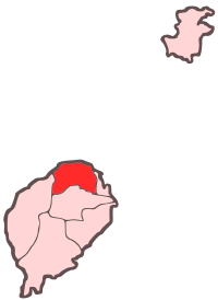 | |
|---|---|---|
| Geography | ||
| Landmarks | ||
| Culture | ||