List of highest mountains on Earth
There are at least 109 mountains on Earth with elevations greater than 7,200 metres (23,622 ft) above sea level. The vast majority of these mountains are located on the edge of the Indian subcontinent and Tibet, with some peaks in Central Asia. Only those summits are included that, by an objective measure, may be considered individual mountains as opposed to subsidiary peaks.
Considerations
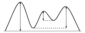
The dividing line between a mountain with multiple peaks and separate mountains is not always clear (see also Highest unclimbed mountain). A popular and intuitive way to distinguish mountains from subsidiary peaks is by their height above the highest saddle connecting it to a higher summit, a measure called topographic prominence or re-ascent (the higher summit is called the "parent peak"). A common definition of a mountain is a summit with 300 m (980 ft) prominence. Alternatively, a relative prominence (prominence/height) is used (usually 7–8%) to reflect that in higher mountain ranges everything is on a larger scale. The table below lists the highest 100 summits with at least 500 m (1,640 ft) prominence, approximating a 7% relative prominence. A drawback of a prominence-based list is that it may exclude well-known or spectacular mountains that are connected via a high ridge to a taller summit, such as Eiger or Nuptse. A few such peaks and mountains with nearly sufficient prominence are included but not numbered in this list.
It is very unlikely that all given heights are correct to the nearest metre; indeed, the sea level is often problematic to define when a mountain is remote from the sea. Different sources often differ by many metres, and the heights given below may well differ from those elsewhere in this encyclopedia. As an extreme example, Ulugh Muztagh on the north Tibetan Plateau is often listed as 7,723 m (25,338 ft) to 7,754 m (25,440 ft), but appears to be only 6,973 m (22,877 ft) to 6,987 m (22,923 ft). Some mountains differ by > 100 m (330 ft) on different maps, while even very thorough current measurements of Mount Everest range from 8,840 m (29,003 ft) to 8,850 m (29,035 ft). These discrepancies serve to emphasize the uncertainties in the listed heights.
Though some parts of the world, especially the most mountainous parts, have never been thoroughly mapped, it is unlikely that any mountains this high have been overlooked, because synthetic aperture radar can and has been used to measure elevations of most otherwise inaccessible places. Still, heights and/or prominences may be revised, so that the order of the list may change and even "new" mountains could enter the list over time. To be safe, the list has been extended to include all 7,200 m (23,622 ft) peaks.
The highest mountains above sea level are generally not the highest above the surrounding terrain. There is no precise definition of surrounding base, but Denali, Mount Kilimanjaro and Nanga Parbat are possible candidates for the tallest mountain on land by this measure. The bases of mountain islands are below sea level, and given this consideration Mauna Kea (4,207 m (13,802 ft) above sea level) is the world's tallest mountain and volcano, rising about 10,203 m (33,474 ft) from the Pacific Ocean floor. Ojos del Salado has the greatest rise on Earth—13,420 m (44,029 ft) from the summit to the bottom of the Atacama Trench about 560 km (350 mi) away, though most of this rise is not part of the mountain.
The highest mountains are also not generally the most voluminous. Mauna Loa (4,169 m or 13,678 ft) is the largest mountain on Earth in terms of base area (about 2,000 sq mi or 5,200 km2) and volume (about 10,000 cu mi or 42,000 km3), although, due to the intergrade of lava from Kilauea, Hualalai and Mauna Kea, the volume can only be estimated based on surface area and height of the edifice. Mt. Kilimanjaro is the largest non-shield volcano in terms of both base area (245 sq mi or 635 km2) and volume (1,150 cu mi or 4,793 km3). Mount Logan is the largest non-volcanic mountain in base area (120 sq mi or 311 km2).
The highest mountains above sea level are also not those with peaks farthest from the centre of the Earth, because the figure of the Earth is not spherical. Sea level closer to the equator is several kilometres farther from the centre of the Earth. The summit of Chimborazo, Ecuador's tallest mountain, is usually considered to be the farthest point from the Earth's centre, although the southern summit of Peru's tallest mountain, Huascarán, is another contender.[1] Both have elevations above sea level more than 2 km less than that of Everest.
Geographical distribution
Almost all mountains in the list are located in the Himalaya and Karakoram ranges to the south and west of the Tibetan plateau. In fact, all 7,000 m (23,000 ft) peaks in the world are located in the centre of Asia (East Asia, Central Asia and South Asia) in a rectangle edged by Noshaq (7,492 m or 24,580 ft) on the Afghanistan-Pakistan border in the West, Jengish Chokusu, (Tuōmù'ěr Fēng) (7,439 m or 24,406 ft) on the Kyrgyzstan – Xinjiang border to the North, Gongga Shan (Minya Konka) (7,556 m or 24,790 ft) in Sichuan to the East, and Kabru (7,412 m or 24,318 ft) on the Sikkim (India) – Nepal border to the South.
The highest mountain outside of Asia is Aconcagua (6,962 m or 22,841 ft), which one list ranks 189th in the world amongst mountains with a 500 m or 1,640 ft prominence cutoff.[2]
List
Data plots
By country
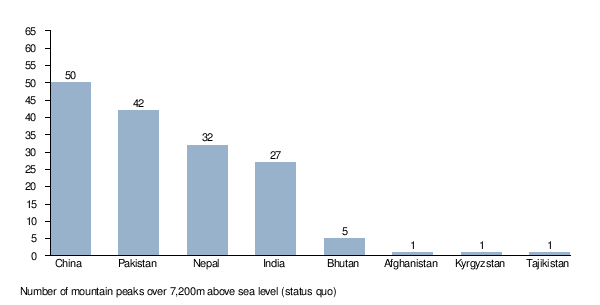
The following graph ranks the countries by number of mountain peaks over 7,200 metres (23,622 ft) above sea level. Note that 38 peaks are on de facto borders and two (Jongsong Peak and Sia Kangri) are on tripoints.
Stem and leaf plot
The following is a stem and leaf plot of the above data. The two digits to the left of the line are the first two digits of the mountain's height (metres), and each digit to the right of the line represents the third digit of the mountain's height. Each number on the right is linked to the corresponding mountain's article. For example, the height of one of the mountains (namely Mount Everest) is 8848 meters. Also, it is apparent that there are five mountains above 8,200 metres.
88 | 4
87 |
86 | 1
85 | 8 1
84 | 8
83 |
82 |
81 | 8 6 6 2
80 | 9 8 5 3 2
79 | 5 4 3 3
78 | 9 8 7 6 2 2 1 0
77 | 9 9 8 8 5 5 4 1 0 0
76 |
9 7 6 6 4 1 1
75 | 7 7 5 5 4 4 4 3 3 1 1
74 | 9 9 9 9 7 6 6 6 5 5 3 3 2 2 2 1 1 1 0 0 0
73 | 8 8 8 8 8 6 6 5 5 5 4 2 1 1 1 0
72 | 9 9 9 8 8 8 8 7 7 6 6 5 4 4 4 3 2 2 1 1 0 0 0 0 0 0 0
Gallery
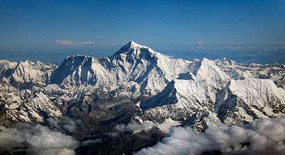
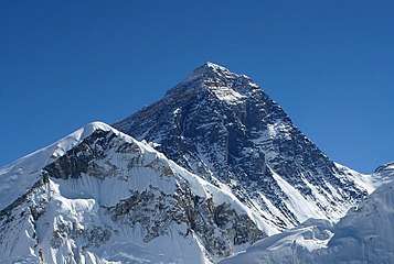 1. The summit of Mount Everest, the highest point on Earth
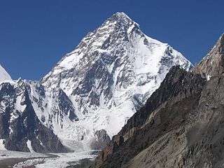
 3. Kangchenjunga, the second-highest mountain of the Himalaya
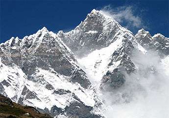
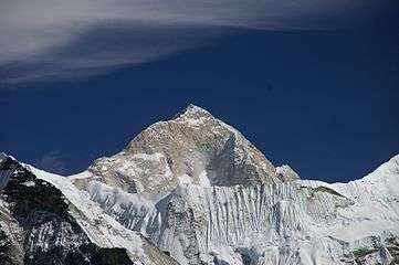
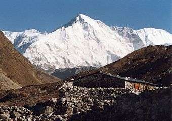
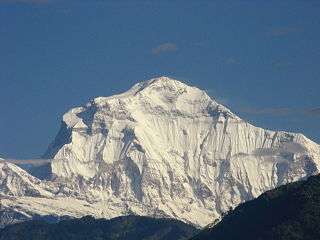 7. Dhaulagiri in the Himalaya
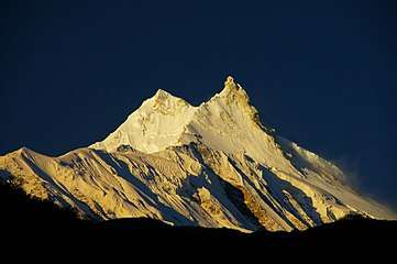
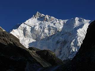
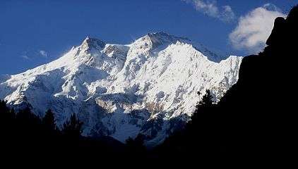 9. Nanga Parbat in the Himalaya
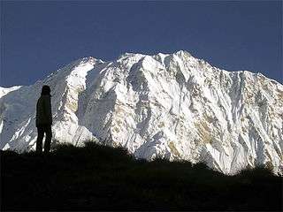 10. Annapurna I in the Himalaya
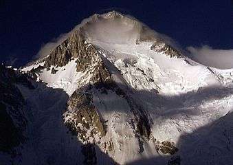 11. Gasherbrum I, the second-highest mountain of the Karakoram
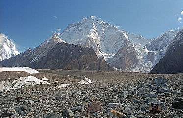 12. Broad Peak, the third-highest mountain of the Karakoram
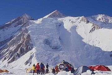 13. Gasherbrum II in the Karakoram
 14. Shishapangma in the Himalaya
See also
- List of elevation extremes by country
- List of Himalayan peaks of Uttarakhand
- List of mountain ranges of the world
- List of mountains
- List of mountains by elevation
- List of mountains on Mars by height
- List of past presumed highest mountains
- List of peaks by prominence
- List of tallest mountains in the Solar System
- List of unclimbed mountains of Nepal
- Olympus Mons, the tallest mountain on any planet in the solar system
- Rheasilvia crater's central peak, the tallest mountain in the solar system
- Seven Summits, the tallest mountains on each continent
- Table of the highest major summits of North America
Notes
- 1 2 3 4 5 6 7 8 9 10 11 12 13 14 15 16 17 18 19 20 21 22 23 24 25 26 27 28 29 30 31 32 33 34 35 36 37 In Pakistan's disputed Gilgit-Baltistan region, claimed by India as a part of its Jammu and Kashmir state.
- 1 2 3 4 5 6 7 8 9 10 11 12 13 14 In the Trans-Karakoram or Shaksgam Tract, ceded by Pakistan from its disputed Gilgit-Baltistan region to China's Xinjiang Uyghur Autonomous Region, claimed by India as a part of its Jammu and Kashmir state.
- 1 2 3 4 5 6 7 8 9 On the border of the Siachen Glacier area, which is controlled by India, but is also claimed by Pakistan.
- ↑ Wholly claimed by China as a part of its Tibet Autonomous Region; on the border with Bhutan according to Bhutan
- 1 2 The Rimo mountains are in the Siachen Glacier region controlled by India, but claimed by Pakistan
- 1 2 Wholly claimed by Bhutan, but on the border of the Tibet Autonomous Region according to China.
References
- ↑ Krulwich, Robert (April 7, 2007). "The 'Highest' Spot on Earth?". Retrieved 21 March 2009.
- ↑ "High Asia summits over 6,750 metres high with 500 metres of re-ascent". viewfinderpanoramas.org. Retrieved January 10, 2014.
- ↑ For Nepal, the heights indicated on the Nepal Topographic Maps are followed. For China and the Baltoro Karakoram, the heights are those of "The Maps of Snow Mountains in China". For the Hispar Karakoram the heights on a Russian 1:100,000 topo map "Archived copy". Archived from the original on 2008-04-27. Retrieved 2008-07-15. seem to be more accurate than the customarily quoted heights probably based on US army maps from the 50s . Elsewhere, unless otherwise indicated, heights are those in Jill Neate's "High Asia".
- ↑ Prominences over 1,500 m were copied from the Ultra Project Prominence Lists, the remainder corresponds to those listed in this table of all mountains above 6650 m
- ↑ Coordinates were established by comparing topographical maps with satellite images and SRTM-derived terrain maps. The terrain maps and satellite images often don't match exactly. An asterisk (*) indicates that the map and image are shifted by more than 100 m (4") and/or that the landscapes around the summit don't match.
- ↑ Here defined as the first higher mountain beyond the key saddle with at least 500 m prominence itself.
- ↑ The number of ascents and failed attempts up to 2004 is extracted from the Alpine Club Himalayan index. These are the number of expeditions (not individuals) that announced their ascent or attempt in a journal. They are probably quite accurate for the rarely climbed peaks (though omissions were noted), but greatly underestimate the number of ascending parties on the easier and/or more popular mountains, like most eight-thousanders. For instance, Mt Everest has been scaled 2,251 times by individuals up to 2004 .
- ↑ Given the large differences between multiple "final" measurements of Mt Everest, the traditional 8,848 m is listed. For more information, see Mount Everest#Measurement.
- ↑ Everest IS parent to K2 by the definition of topographic prominence. See also, the discussion page.
- ↑ Cho Oyu's height is 8,188 m according to the Nepal Survey's 1996 topographical map H8615, which represents the best known measurement to date. Previous estimates have been 8,153 m and 8,201 m
- ↑ The highest (Eastern) summit of Saser Kangri II was climbed on August 24th, 2011 / p / steve-swenson-status. The lower West peak, 2.5 km away, has been climbed in 1984 and twice since.
- ↑ According to the 1996 Himalayan Journal (pp.29–36), the highest point of the Kabru massif (the North summit) was climbed by an Indian Army team in May 1994
- ↑ The height is unknown, but over 7,200 meters on both Chinese and Russian maps of the area.
- ↑ The name and information about this summit was extracted from the May 2003 edition of Japanese Alpine News.
Sources
- Desheng, Mi (1990s). "The Maps of Snow Mountains in China". Chinese Academy of Science.
- Finnish Meteorological Inst. (1990s). Nepal Topographic Maps. Nepalese Survey Dept.
- "High Mountain Info". High Mountain Sports Magazine (now Climb Magazine). (1990–2005).
- Neate, Jill (1990). High Asia: An Illustrated History of the 7,000 Metre Peaks. Mountaineers Books.
- Some other topographic maps and much from the external links listed above
- Soviet military 1:100,000 topographic maps (most from 1980–1981)
External links
- Summitpost (Currently with detailed description of 30 of the top 100 peaks)
- Prominence lists (including all mountains in the world with >1,450m prominence)
- Alpine Club Himalayan index (Especially informative for history of ascents and location of obscure peaks)
- Discussion of frequently misquoted elevations
- BlankontheMap site on mountains of Northern Kashmir
- Digital elevation data, including all the above peaks and many more worldwide
- Hispar area: expedition reports and maps
- List of highest mountains down to 6750 metres
- Google Earth Community (Google Earth KMZ file of Wikipedia list of highest mountains)