Langtang Lirung
| Langtang Lirung | |
|---|---|
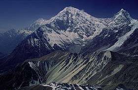 Langtang Lirung as seen from East (Tsergo Ri) | |
| Highest point | |
| Elevation |
7,234 m (23,734 ft) [1] Ranked 99th |
| Prominence | 1,534 m (5,033 ft) [1] |
| Listing | Ultra |
| Coordinates | 28°15′27″N 85°30′57″E / 28.25750°N 85.51583°ECoordinates: 28°15′27″N 85°30′57″E / 28.25750°N 85.51583°E [1] |
| Geography | |
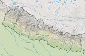 Langtang Lirung Nepal | |
| Location | Langtang, Nepal |
| Parent range | Langtang Himal |
| Climbing | |
| First ascent | October 24, 1978 by Seishi Wada and Pemba Tsering |
| Easiest route | rock/snow/ice climb |
Langtang Lirung is the highest peak of the Langtang Himal, which is a subrange of the Nepalese Himalayas, southwest of the Eight-thousander Shishapangma.
Location
The Langtang Himal forms the western portion of a complex of mountains which also includes the Jugal Himal, home of Shishapangma. This complex lies between the Sun Kosi valley on the east and the Trisuli Gandaki valley on the west. Langtang Lirung lies near the Trisuli Gandaki, and north of the Langtang Khola.
Notable features
Though not high by the standards of major Himalayan peaks, Langtang Lirung is notable for its large vertical relief above local terrain. For example, it rises 5500m above the Trisuli Gandaki to the west in only 16 km. It has a large south face which long resisted climbing attempts. The List of the world's highest 100 mountains puts it at number 99.
Climbing history

The peak was reconnoitered by H. W. Tilman and P. Lloyd in 1949. Attempts were made to climb the peak via the East Ridge in the 1960s, but none got close to the summit.
In 1978, Seishi Wada and Pemba Tsering, from a Japanese-Sherpa expedition, succeeded in reaching the summit, via the same East Ridge route. They made four camps.
According to the Himalayan Index, there have been 14 ascents of Langtang Lirung (in 1978, 1980, 1981, 1982, 1986, 1988, 1989, 1992, 1994, and 1995), mostly by the Southeast or Southwest Ridge routes; and 13 unsuccessful attempts on the peak (these may be underestimates).
On November 9, 2009, Slovenian mountaineer Tomaž Humar, who was on a solo climb (the expedition started on October 5) via the South Face, had an accident during his descent.[2] Sources report that he became stuck on the mountain at an approximate height of 6300 meters with a broken leg (other sources also report broken ribs and damaged spine[3]). His only contact with the base camp staff via a satellite phone was made on the day of the accident, and he appeared to be in a critical condition.[4] The rescue party found his body on November 14 at the height of 5600 m. Presumably, he died on November 9 or 10.[5]
References
- 1 2 3 "High Asia II: Himalaya of Nepal, Bhutan, Sikkim and adjoining region of Tibet". Peaklist.org. Retrieved 2014-05-30.
- ↑ "Tomaz Humar Stuck on Langtang Lirung with broken leg??". www.everestnews.com.
- ↑ "Langtang Lirung rescue update: Tomaz Humar missing, Swiss rescuers stuck in BC". MountEverest.net.
- ↑ "Tomaz Humar Missing on Langtang Lirung". www.everestnews.com.
- ↑ "Slovenian climber dies in Himalayas". Topnews.in. 2007-08-19. Retrieved 2009-11-14.
Sources
- H. Adams Carter, "Classification of the Himalaya," American Alpine Journal 1985.
- Jill Neate, High Asia: An Illustrated History of the 7000 Metre Peaks, ISBN 0-89886-238-8
- Himalayan Index
- DEM files for the Himalaya (Corrected versions of SRTM data)
- World's Highest Mountains
External links
- A list of mountains ranked by local relief and steepness showing Langtang Lirung as the world #20.
- Pictures of Langtang Lirung with Cheng Liru
- Tomaž Humar dies in Langtang Lirung