Noijin Kangsang
| Noijin Kangsang | |
|---|---|
| Norin Kang | |
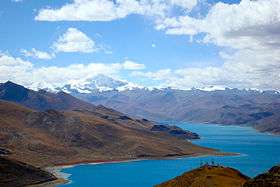 Looking from Kamba La to Yamdrok Yumtso, with towering Noijinkangsang in the distance | |
| Highest point | |
| Elevation |
7,191 m (23,593 ft) [1] Ranked 105th |
| Prominence | 2,145 m (7,037 ft) [1] |
| Listing | Ultra |
| Coordinates | 28°56′54″N 90°10′42″E / 28.94833°N 90.17833°ECoordinates: 28°56′54″N 90°10′42″E / 28.94833°N 90.17833°E [1] |
| Geography | |
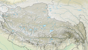 Noijin Kangsang Location in Tibet | |
| Location | Tibet,China |
| Parent range | Lhagoi Kangri |
| Climbing | |
| First ascent | 1986 by a Chinese expedition |
Noijin Kangsang (Chinese: 宁金抗沙峰, also Norin Kang or Noijinkangsang) is the highest peak of Lhagoi Kangri mountain range in the Tibet Autonomous Region in China. It lies between the Yarlung Tsangpo River (to the north), Yamdrok Lake (to the east) and the Himalayas mountain range (to the south).
Noijin Kangsang was first climbed via the South Face and Southwest Ridge on 28 April 1986 by a Chinese expedition.
See also
References
- 1 2 3 "High Asia II: Himalaya of Nepal, Bhutan, Sikkim and adjoining region of Tibet". Peaklist.org. Retrieved 2014-06-01.
External links
This article is issued from
Wikipedia.
The text is licensed under Creative Commons - Attribution - Sharealike.
Additional terms may apply for the media files.