Actual Ground Position Line
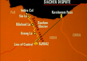
AGPL shown with yellow-colored dotted line
The Actual Ground Position Line (AGPL) is the line that divides current positions of Indian and Pakistani troops in the Siachen Glacier region.[1][2] The line extends from the northernmost point of the LOC (Line of Control) to Indira Col. The AGPL is approximately 110 kilometres (68 mi) long.[3][4]
Geographical location
Red dotted line is AGPL, east of which is the Siachen Glacier controlled by the Indian army.
This line runs across the edge of the Saltoro Ridge, which is a mountainous plateau with peaks which have heights in excess of 7,000 meters. The Indian soldiers hold on to the heights on the ridge, preventing the Pakistani soldiers from climbing up to the Saltoro Range heights. The current position of the AGPL follows the general line:
Indira Col - Sia La pass - Saltoro Kangri 1 - Bilafond La pass - K12 - Gyong La pass - NJ9842[5]
See also
References
- ↑ The fight for Siachen
- ↑ "Archived copy". Archived from the original on 2015-04-12. Retrieved 2015-04-07.
- ↑ They shall not pass
- ↑ "Bullish on siachen". Archived from the original on 2014-02-22. Retrieved 2014-02-17.
- ↑ "Manning the Siachen Glacier". Bharat Rakshak Monitor. 2003. Archived from the original on 2012-06-14. Retrieved 2011-01-27.
This article is issued from
Wikipedia.
The text is licensed under Creative Commons - Attribution - Sharealike.
Additional terms may apply for the media files.