Linwood, New Zealand
| Linwood | |
|---|---|
 Linwood | |
| Coordinates: 43°31′53″S 172°40′21″E / 43.53139°S 172.67250°ECoordinates: 43°31′53″S 172°40′21″E / 43.53139°S 172.67250°E | |
| Area | |
| • Total | 2.8345 km2 (1.0944 sq mi) |
| Population (2013) | |
| • Total | 4,290 |
| • Density | 1,500/km2 (3,900/sq mi) |
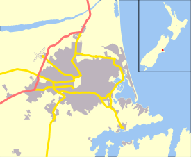
Linwood is an inner suburb of the city of Christchurch, New Zealand. It lies to the east of the city centre, mostly between Ferry Road and Linwood Avenue, two of the major arterial roads to the eastern suburbs of Christchurch.
History
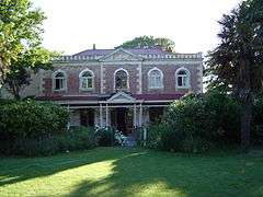
Linwood was given its name by Joseph Brittan, who purchased rural section 300 in Avonside. The adjoining rural section 301 was to be part of the farm, but the right was sold but probably farmed with rural section 300 and was eventually bought back by his son in 1874. To this was added a small part of section 30 to give access in 1855 and 21 year lease for the adjoining sections in 1862 giving a total area of about 380 acres (about 150ha)[1].[2] He called the farm Linwood, as he was from Linwood, Hampshire.[3] Brittan built Linwood House at 30 Linwood Avenue in 1857, which stood there until demolition following the February 2011 Christchurch earthquake.[2][4]
Christchurch lacked an accessible port before the construction of the Lyttelton rail tunnel in 1867. This posed a significant problem for the fledgling city. A barge service along what is now Linwood Avenue was mooted prior to this tunnel but was never completed.
Goods and services
Linwood's commercial area is concentrated around the intersection of Linwood Avenue and Aldwins Road / Buckleys Road. Eastgate Mall lies on the eastern corner of this intersection.
Education
Local schools include:
- Linwood College
- Linwood Intermediate
- Linwood Avenue Primary School
- Linwood North School
Notable People
References
- ↑ Archives NZ land records
- 1 2 "Linwood House". Register of Historic Places. Heritage New Zealand. Retrieved 13 August 2011.
- ↑ Greenaway, Richard L. N. (June 2007). "Avonside Anglican Parish Cemetery Tour" (PDF). Christchurch City Libraries. p. 9. Retrieved 13 August 2011.
- ↑ Cronshaw, Tim (5 March 2011). "Heritage heartbreak looms". The Press. Retrieved 13 August 2011.