Lindesnes Region
| Lindesnes Region Lindesnesregionen | |
|---|---|
| Metropolitan Region (Metro) | |
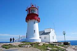 Lindesnes Lighthouse, the southernmost point of Norway | |
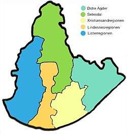 Lindesnes Region in orange, in the map of Agder. | |
| Coordinates: 58°36′N 7°48′E / 58.6°N 7.8°ECoordinates: 58°36′N 7°48′E / 58.6°N 7.8°E | |
| Country | Norway |
| Capital | Mandal |
| County (fylke) | Vest-Agder |
| Area | |
| • Total | 2,072.55 km2 (800.22 sq mi) |
| Population (2016) | |
| • Total | 25,454 |
| • Density | 12/km2 (32/sq mi) |
The Lindesnes Region (or Mandal Region) is the metropolitan region surrounding the town of Mandal in Southern Norway. The region has no governmental functions, but it encompasses five municipalities in Vest-Agder county, primarily covering two large river valleys: Mandalen and Audnedalen. The region is Norway's southernmost region and it borders the Kristiansand Region to the east and the Lister Region to the west.
Municipalities
The Lindesnes Region includes the following municipalities:
| Nr | Map | Name | Coat of arms | Adm. center | Population[1] | Areal km²[2] |
Language | Location |
|---|---|---|---|---|---|---|---|---|
| 1002 | Mandal | Mandal | 15,529 | 222.56 | Bokmål | Coast | ||
| 1021 | Marnardal | Heddeland | 2,290 | 395.01 | Nøytral | Inland | ||
| 1026 | Åseral | Kyrkjebygda | 942 | 887.52 | Nynorsk | Inland | ||
| 1027 | Audnedal | Konsmo | 1,750 | 251.45 | Nøytral | Inland | ||
| 1029 | Lindesnes | Vigeland | 4,943 | 316.01 | Bokmål | Coast |
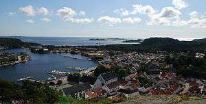
Mandal, the largest city and capital of the Lindesnes Region
References
- ↑ "Population 1 January. The whole country, counties and municipalities". Statistisk Sentralbyrå. Retrieved 2016-12-30.
- ↑ "Arealstatistikk for Norge" (PDF) (in Norwegian). Statens kartverk. 2014. Retrieved 2016-12-30.
| Counties | ||
|---|---|---|
| Cities | ||
| Towns | ||
| Municipalities | ||
This article is issued from
Wikipedia.
The text is licensed under Creative Commons - Attribution - Sharealike.
Additional terms may apply for the media files.