Sira, Norway
| Sira | |
|---|---|
| Village | |
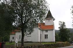 View of the village church | |
 Sira Location of the village  Sira Sira (Norway) | |
| Coordinates: 58°25′13″N 06°39′46″E / 58.42028°N 6.66278°ECoordinates: 58°25′13″N 06°39′46″E / 58.42028°N 6.66278°E | |
| Country | Norway |
| Region | Southern Norway |
| County | Vest-Agder |
| District | Lister |
| Municipality | Flekkefjord |
| Area[1] | |
| • Total | 0.66 km2 (0.25 sq mi) |
| Elevation[2] | 76 m (249 ft) |
| Population (2015)[1] | |
| • Total | 630 |
| • Density | 955/km2 (2,470/sq mi) |
| Time zone | UTC+01:00 (CET) |
| • Summer (DST) | UTC+02:00 (CEST) |
| Post Code | 4438 Sira |
Sira is a village in Flekkefjord municipality in Vest-Agder county, Norway. The village is located immediately east of the county border of Vest-Agder and Rogaland. The European route E39 highway passes by the village and the Sørlandet Line runs right through the village, stopping at Sira Station. The 0.66-square-kilometre (160-acre) village has a population (2015) of 630, giving the village a population density of 955 inhabitants per square kilometre (2,470/sq mi).[1]
Sira lies along the Sira River, just south of the lake Sirdalsvatnet. The river and lake are both a part of the Sira-Kvina hydropower system. Sira was the administrative centre of the former municipality of Bakke which was dissolved and merged into Flekkefjord in 1965. Bakke Church lies at the southern end of the village.[3]
References
- 1 2 3 Statistisk sentralbyrå (1 January 2015). "Urban settlements. Population and area, by municipality".
- ↑ "Sira, Flekkefjord (Vest-Agder)". yr.no. Retrieved 2016-09-09.
- ↑ Store norske leksikon. "Sira – tettsted" (in Norwegian). Retrieved 2016-09-09.