Liknes
| Liknes | |
|---|---|
| Village | |
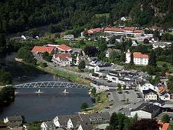 View of the village | |
 Liknes Location of the village  Liknes Liknes (Norway) | |
| Coordinates: 58°18′43″N 06°57′42″E / 58.31194°N 6.96167°ECoordinates: 58°18′43″N 06°57′42″E / 58.31194°N 6.96167°E | |
| Country | Norway |
| Region | Southern Norway |
| County | Vest-Agder |
| District | Lister |
| Municipality | Kvinesdal |
| Area[1] | |
| • Total | 1.97 km2 (0.76 sq mi) |
| Elevation[2] | 16 m (52 ft) |
| Population (2015)[1] | |
| • Total | 2,462 |
| • Density | 1,250/km2 (3,200/sq mi) |
| Time zone | UTC+01:00 (CET) |
| • Summer (DST) | UTC+02:00 (CEST) |
| Post Code | 4480 Kvinesdal |
Liknes is the administrative centre of Kvinesdal municipality in Vest-Agder county, Norway. The village is located along the river Kvina, about 5.5 kilometres (3.4 mi) north of the mouth where it empties into the Fedafjorden. The village of Storekvina lies about 7 kilometres (4.3 mi) to the north of Liknes. The 1.97-square-kilometre (490-acre) village has a population (2015) of 2,462 which gives the village a population density of 1,250 inhabitants per square kilometre (3,200/sq mi).[1]
The village is the largest urban area in the municipality. There are stores, a school, and Kvinesdal Church. Just east of the village is the Saron Valley where the missionary center, Troens Bevis Verdens Evangelisering is located. From 1900 until 1917, the municipality of Kvinesdal was named Liknes, after the village.[3]
Media gallery
 View of Liknes and the river Kvina
.jpg) View of Liknes in 1953
View of Liknes in 1953 Kvinesdal Church in Liknes
References
- 1 2 3 Statistisk sentralbyrå (1 January 2015). "Urban settlements. Population and area, by municipality".
- ↑ "Liknes, Kvinesdal (Vest-Agder)". yr.no. Retrieved 2016-09-20.
- ↑ Store norske leksikon. "Liknes - tettsted" (in Norwegian). Retrieved 2016-09-20.