Kyrkjebygda
| Kyrkjebygda Kyrkjebygdi | |
|---|---|
| Village | |
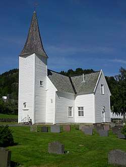 View of the village church | |
 Kyrkjebygda Location of the village  Kyrkjebygda Kyrkjebygda (Norway) | |
| Coordinates: 58°36′54″N 07°24′50″E / 58.61500°N 7.41389°ECoordinates: 58°36′54″N 07°24′50″E / 58.61500°N 7.41389°E | |
| Country | Norway |
| Region | Southern Norway |
| County | Vest-Agder |
| District | Lindesnes |
| Municipality | Åseral |
| Elevation[1] | 269 m (883 ft) |
| Time zone | UTC+01:00 (CET) |
| • Summer (DST) | UTC+02:00 (CEST) |
| Post Code | 4540 Åseral |
Kyrkjebygda or Kyrkjebygdi is the administrative centre of Åseral municipality in Vest-Agder county, Norway. The village is located on a small flat plain in a valley at the northern end of the lake Øre at the confluence of the rivers Logna and Monn. The Monn river valley heads north-northwest to the village of Ljosland and the Logna river valley heads north-northeast to the villages of Åknes and Bortelid.
The name Kyrkjebygda literally means "church village" in the Norwegian language. It has this name since it has been the site of Åseral Church for centuries.[2]
References
- ↑ "Kyrkjebygda, Åseral (Vest-Agder)". yr.no. Retrieved 2016-11-11.
- ↑ "Åseral kyrkje" (in Norwegian). SetesdalsWiki. Retrieved 2016-11-11.
This article is issued from
Wikipedia.
The text is licensed under Creative Commons - Attribution - Sharealike.
Additional terms may apply for the media files.