Leirfjord
| Leirfjord kommune | |||
|---|---|---|---|
| Municipality | |||
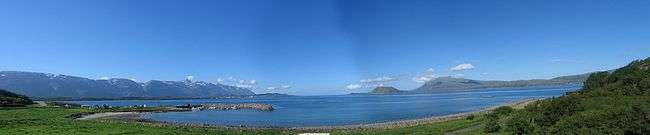
 View of Angerneset in western Leirfjord | |||
| |||
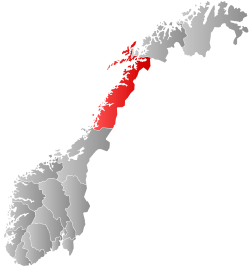
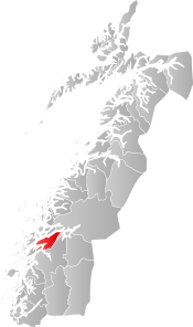 Leirfjord within Nordland | |||
| Coordinates: 66°06′46″N 13°07′51″E / 66.11278°N 13.13083°ECoordinates: 66°06′46″N 13°07′51″E / 66.11278°N 13.13083°E | |||
| Country | Norway | ||
| County | Nordland | ||
| District | Helgeland | ||
| Established | 1915 | ||
| Administrative centre | Leland | ||
| Government | |||
| • Mayor (2015) | Ivan Haugland (Ap) | ||
| Area | |||
| • Total | 465.22 km2 (179.62 sq mi) | ||
| • Land | 451.04 km2 (174.15 sq mi) | ||
| • Water | 14.18 km2 (5.47 sq mi) | ||
| Area rank | #216 in Norway | ||
| Population (2017) | |||
| • Total | 2,278 | ||
| • Rank | #308 in Norway | ||
| • Density | 5.1/km2 (13/sq mi) | ||
| • Change (10 years) | 7.3% | ||
| Demonym(s) | Leirfjording[1] | ||
| Time zone | UTC+01:00 (CET) | ||
| • Summer (DST) | UTC+02:00 (CEST) | ||
| ISO 3166 code | NO-1822 | ||
| Official language form | Neutral | ||
| Website |
leirfjord | ||
Leirfjord is a municipality in Nordland county, Norway. It is part of the Helgeland traditional region. The administrative centre of the municipality is the village of Leland. Other villages in Leirfjord include Bardalssjøen and Sundøy. The large Helgeland Bridge is partly located in the municipality, connecting it to Alstahaug and the town of Sandnessjøen.
The 465-square-kilometre (180 sq mi) municipality is the 216th largest by area out of the 422 municipalities in Norway. Leirfjord is the 308th most populous municipality in Norway with a population of 2,278. The municipality's population density is 5.1 inhabitants per square kilometre (13/sq mi) and its population has increased by 7.3% over the last decade.[2]
General information
The municipality of Leirfjord was established on 1 July 1915 when it was separated from the municipality of Stamnes. Initially, the municipality had 2,003 residents. In 1945, a small part of Nesna (population: 45) was merged into Leirfjord. On 1 January 1964, Leirfjord (population: 1,936) was merged with the southern part of Nesna (population: 580) and the parts of Tjøtta on the island of Alsta (population: 180) to form a new, larger municipality of Leirfjord.[3]
Name
The municipality is named after the Leirfjorden. The old name of the fjord was probably just Leiri, derived from the name of the river Leira, which has its mouth in the end of the fjord. The river name is derived from the word leirr which means "clay".[4]
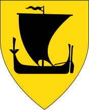
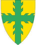
Coat-of-arms
The coat-of-arms is from modern times (1992). The arms show a green branch cross on a gold background. It symbolizes forestry and agriculture in the municipality. The arms were designed by Jarle E. Henriksen from Sandnessjøen.[5]
Churches
The Church of Norway has one parish (sokn) within the municipality of Leirfjord. It is part of the Nord-Helgeland prosti (deanery) in the Diocese of Sør-Hålogaland.
| Parish (Sokn) | Church Name | Location of the Church | Year Built |
|---|---|---|---|
| Leirfjord | Bardal Church | Bardalssjøen | 1887 |
| Leirfjord Church | Leland | 1867 |
Geography
The municipality of Leirfjord is centered on the Leirfjorden, with most of the municipality on the mainland and a small part on the northeastern part of the island of Alsta. The Sundøy Bridge connects the mainland to the northeastern part of the island of Alsta and the Helgeland Bridge connects it to the rest of Alsta and the town of Sandnessjøen. The Ranfjorden runs along the northern part of Leirfjord and the Vefsnfjorden runs along the southern part of the municipality.
Government
All municipalities in Norway, including Leirfjord, are responsible for primary education (through 10th grade), outpatient health services, senior citizen services, unemployment and other social services, zoning, economic development, and municipal roads. The municipality is governed by a municipal council of elected representatives, which in turn elect a mayor.
Municipal council
The municipal council (Kommunestyre) of Leirfjord is made up of 19 representatives that are elected to four year terms. Currently, the party breakdown is as follows:[6]
| Party Name | Name in Norwegian | Number of representatives | |
|---|---|---|---|
| Labour Party | Arbeiderpartiet | 9 | |
| Progress Party | Fremskrittspartiet | 2 | |
| Conservative Party | Høyre | 1 | |
| Centre Party | Senterpartiet | 5 | |
| Socialist Left Party | Sosialistisk Venstreparti | 2 | |
| Total number of members: | 19 | ||
References
- ↑ "Navn på steder og personer: Innbyggjarnamn" (in Norwegian). Språkrådet. Retrieved 2015-12-01.
- ↑ Statistisk sentralbyrå (2017). "Table: 06913: Population 1 January and population changes during the calendar year (M)" (in Norwegian). Retrieved 2017-09-16.
- ↑ Jukvam, Dag (1999). "Historisk oversikt over endringer i kommune- og fylkesinndelingen" (PDF) (in Norwegian). Statistisk sentralbyrå.
- ↑ Store norske leksikon. "Leirfjord" (in Norwegian). Retrieved 2012-01-10.
- ↑ "Leirfjord" (in Norwegian). Leirfjord kommune. Archived from the original on 2007-03-10. Retrieved 2008-11-23.
- ↑ "Table: 04813: Members of the local councils, by party/electoral list at the Municipal Council election (M)" (in Norwegian). Statistics Norway. 2015.
External links
- Municipal fact sheet from Statistics Norway (in Norwegian)
| Wikimedia Commons has media related to Leirfjord. |

| |||||||||||||||||
| |||||||||||||||||