Mont-Dore
| Mont-Dore | |
|---|---|
| Commune | |
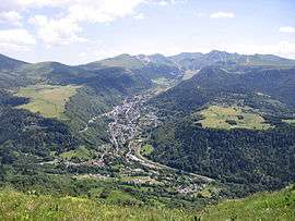 Mont-Dore with the Puy de Sancy in the background | |
 Mont-Dore Location within Auvergne-Rhône-Alpes region  Mont-Dore | |
| Coordinates: 45°34′38″N 2°48′35″E / 45.5772°N 2.8097°ECoordinates: 45°34′38″N 2°48′35″E / 45.5772°N 2.8097°E | |
| Country | France |
| Region | Auvergne-Rhône-Alpes |
| Department | Puy-de-Dôme |
| Arrondissement | Issoire |
| Canton | Le Sancy |
| Government | |
| • Mayor (2001–) | Jean-François Dubourg |
| Area1 | 35.87 km2 (13.85 sq mi) |
| Population (2006)2 | 1,504 |
| • Density | 42/km2 (110/sq mi) |
| Time zone | UTC+1 (CET) |
| • Summer (DST) | UTC+2 (CEST) |
| INSEE/Postal code | 63236 /63240 |
| Elevation |
897–1,883 m (2,943–6,178 ft) (avg. 1,050 m or 3,440 ft) |
|
1 French Land Register data, which excludes lakes, ponds, glaciers > 1 km2 (0.386 sq mi or 247 acres) and river estuaries. 2 Population without double counting: residents of multiple communes (e.g., students and military personnel) only counted once. | |
Mont-Dore[1] (Mont Dòr in Auvergnat, and Mont-Dore-les-Bains), in common usage Le Mont-Dore, is a commune in the Puy-de-Dôme department in Auvergne-Rhône-Alpes in central France.
Geography
Mont-Dore is located in the Massif Central, on the right bank of the Dordogne River not far from its source, and 50 km (31 mi) by road S.W. of Clermont-Ferrand. The Monts Dore close the valley towards the south.
Thermal springs
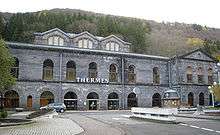
The thermal springs of Mont-Dore, now numbering twelve, were known to the Romans. Sodium bicarbonate, iron and arsenic are the principal ingredients of the waters, which are used both for drinking and bathing. Hot baths are characteristic of the treatment; they are believed to be efficacious for tuberculosis, bronchitis, asthma, and nervous and rheumatic paralysis. Due to the elevation and exposure of the valley, the climate of Mont-Dore is relatively severe, and the season only lasts from 15 June to 15 September. The bath-house was rebuilt in 1891-1894.
Ski resort
Mont-Dore is a ski resort with runs on the slopes of the Puy de Sancy and the Puy Ferrand. Thirty runs account for 42 km of downhill skiing, served by a number of lifts of different types. There are also 25 km of cross-country trails.
Sights
In the town park, along the Dordogne, relics of the old Roman baths have been collected. The surrounding country, with its fir woods, pastures, waterfalls and mountains, is very attractive. To the south is the Puy de Sancy (1,886 m), the loftiest peak of central France.
Gallery
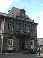 The Hôtel de Ville
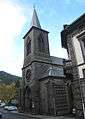 Church
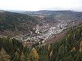 View from above the Grande Cascade
See also
| Wikimedia Commons has media related to Mont-Dore (Puy-de-Dôme). |
| Wikivoyage has a travel guide for Mont Dore. |
References
- INSEE commune file

| Authority control |
|---|