Purley, London
| Purley | |
|---|---|
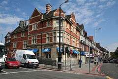 Street scene in town centre with local Pizza Express branch, formerly the Westminster Bank in foreground | |
 Purley Purley shown within Greater London | |
| OS grid reference | TQ313615 |
| London borough | |
| Ceremonial county | Greater London |
| Region | |
| Country | England |
| Sovereign state | United Kingdom |
| Post town | PURLEY |
| Postcode district | CR8 |
| Dialling code | 020 |
| Police | Metropolitan |
| Fire | London |
| Ambulance | London |
| EU Parliament | London |
| UK Parliament | |
| London Assembly | |
Purley is a town in South London within the London Borough of Croydon. It is located south of Croydon, and is situated 11.7 miles (18.8 km) south of Charing Cross. It has a population of about 14,000 (2011).
History
Toponymy
The name derives from Purley Farm which was originally part of the Benendon estates owned in the middle ages by the Huscarle and Carew families. They also held estates in Berkshire and men from this area who had worked on the estates were brought up to 'headquarters' to work and were generally known as xx de Pirley or xx de Woodcote etc denoting the villages from whence they came. (there was no consistent spelling in those days so you will find the Berkshire Purley variously spelled Purle, P'lee, Pirley etc) One, John de Purley, tenanted the farm which became known as Purley Farm after his family succeeded him for several generations. The original meaning of Purley was a riverside field inhabited by snipe or bittern.
Local government
Under the Local Government Act 1894, Purley became part of the Croydon Rural District of Surrey. In 1915 Purley and the neighbouring town of Coulsdon formed the Coulsdon and Purley Urban District which in 1965, under the London Government Act 1963, was abolished and its area transferred to Greater London and used to form part of the London Borough of Croydon.
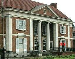
The urban district council was based in a colonial-style building opened in 1930. The building, on the A23 Brighton Road near Reedham Station, became the property of the London Borough of Croydon and was sold to developers. It was left derelict for many years but was converted into flats in 2012.
Aviation
Kenley Aerodrome, to the east of the town, is currently official property of the Ministry of Defence. It was one of the most important fighter stations – together with Croydon Airport and Biggin Hill – during World War II.
Suburban growth
Purley grew rapidly in the 1920s and 1930s, providing spacious homes in a green environment. Northeast Purley stretches into the chalk hill spurs of the North Downs.
One road, Promenade de Verdun, created by William Webb, has a distinction all of its own. It is 600 yards (550 m) long and has on one side Lombardy poplars planted in local soil mixed with French earth specially shipped over to the UK. A plaque at one end of the road explains that the French ministry of the interior donated the soil from Armentières, as a memorial to the alliance of World War One and the soldiers who died. At the other end stands an obelisk carved from a single piece of stone with the inscription "Aux soldats de France morts glorieusement pendant la Grande Guerre".[1]
The 32nd Surrey Battalion of the Home Guard was known as the Factory Battalion, and had the specific task of guarding the Purley Way factories: its units were mainly based on staff from the individual firms. The factories adjoining Croydon Airport took the worst of the air raid of 15 August 1940: the British NSF factory was almost entirely destroyed, and the Bourjois factory gutted, with a total of over sixty civilian deaths.[2]
A comprehensive history of Purley and its growth around Caterham Junction (now Purley Station) with the coming of the railways some 150 years ago is found in the Bourne Society's 'Purley Village History' and in its Local History Records publications.
The Webb Estate made headlines in a 2002 survey, which found that it had over the years attracted the highest-earning residents in the UK. In the same year Purley topped Britain's rich list becoming the most affluent suburb and consistently features among the most affluent suburbs in Britain owing to its exclusive gated estates, large houses and greenery yet only less than 30 minutes from central London thus attracting wealthy city workers.[3]
Education
Purley is home to a number of schools; including four notable Catholic schools, two of which are in Peaks Hill, Surrey: these schools are The John Fisher School a high-performing Catholic all boys state school (formerly an independent and then highly selective state school), Laleham Lea Primary School a co-educational prep-school and Oakwood School, a co-educational Catholic primary. Cumnor House School, a prep school, is also in Purley. Oakwood Prep School is located on Godstone Road, Purley, and has been awarded Outstanding by Ofsted for over 10 years. Purley has one of the UK's longest-established language schools, Purley Language College, founded in 1928.
Other schools in Purley include:
Retail and commerce
.jpg)
Purley used to have many different kinds of shops such as greengrocers, butchers, fishmongers, card shops, sport shops, etc. The old Sainsbury's was closed in the early 1980s (and has now been demolished as part of redevelopment plans by the congregation of Purley Baptist Church). Since the opening of a new Sainsbury's in the early 1980s (closed 2001) and, more significantly, a Tesco superstore in 1991, there has been a shift in the town's retail offering towards estate agents, restaurants and bars. In 2006, further change was on the cards as Tesco proposed to replace the store with a 6-storey building containing affordable flats above a new store. These expansion plans were subsequently shelved.
The island opposite Purley Baptist Church has been refurbished and the Church, under the banner of 58:12[4] (a company and charity set up by the Church) are planning to redevelop it. Other partners in the development of a strategy for the regeneration of central Purley include the Purley & Woodcote Residents' Association and Purley Rotary who actively participate in the Neighbourhood Partnership forums hosted by Croydon Council.
Demography
White British is the largest ethnic group at 61%, as of the 2011 census.[5]
Politics
Purley has consistently returned Conservative Party MPs to the local seat of Croydon South since 1974 and has also returned Conservative members to Croydon Council since 1965. Since the north of Croydon tends to return Labour councillors, the two halves of the borough are often at loggerheads. In the 2006 local elections the Conservatives were returned to power in Croydon removing Liberal Democrats and replacing Labour from the local political scene. Prominent members of the new Council are residents of Purley & of Woodcote (now part of Coulsdon West Ward). In 2018, Purley was split into two wards; Purley and Woodcote, and Purley Oaks and Riddlesdown.
Notable references in fiction
- On television the town became known in the sitcom, Terry and June where Terry and June Medford (Terry Scott and June Whitfield), had moved after the characters' previous series, Happy Ever After. The sitcom was set on the cusp of Purley and Wallington (on Church Road in a house within sight of St Mark's Church) and the opening credits featured them searching for each other around the (now unrecognisable) Whitgift Centre – a shopping precinct in Croydon.
- One of the houses used in Footballer's Wives is 7 Rose Walk, Purley, owned by former Crystal Palace FC Chairman Ron Noades
.
- Purley is famous for a reference in both the "Marriage Guidance Counsellor", "Nudge Nudge", and "Kilimanjaro Expedition" (mentioned only in version in And Now for Something Completely Different film) sketches by Monty Python.
- The CBBC children's sitcom Little Howard's Big Question is based in Purley, featuring continuous references towards Purley and Croydon.
Notable residents
- Michael Arthur, Vice-Chancellor of Leeds University, Provost of University College London from September 2013, was born in Purley
- Jay Aston, singer with Bucks Fizz, was born in Purley.
- Derren Brown, magician and mentalist, was born and grew up in Purley.
- June Brown, actress, used to live in South Croydon near Purley.
- Laura Hamilton, TV presenter and Dancing on Ice Contestant, lives in Purley
- Peter Cushing OBE, actor, grew up and went to school in Purley.
- Shelagh Fraser, actress, was born in Purley[6]
- Andy Frampton, professional footballer who currently plays for AFC Wimbledon, grew up in Purley.
- Nigel Harman, actor, was born and grew up in Purley.
- Sir Bernard Ingham, Margaret Thatcher's former press secretary, lives in Purley.
- Sir David P. Lane, oncologist best known for identifying P53, went to school and grew up in Purley.
- Martin Lee, singer with Brotherhood of Man, was born in Purley.
- Archibald Low, pioneer of radio guidance systems, was born in Purley.
- Ray Mears (author), TV survivalist
- Innes Hope Pearse, doctor and co-founder of the Peckham Experiment, grew up in Purley.[7]
- Francis Rossi, lead singer of Status Quo, lives in the Webb Estate in Purley.
- John Horne Tooke, an English politician and philologist, lived in Purley at the end of the 18th century where he began writing Epea Pteroenta, Or, The Diversions of Purley.
- Ron Noades, former chairman of Wimbledon FC, Crystal Palace FC and Brentford FC and owner of the Altonwood Golf Group, lived in Rose Walk, Purley, from 1993 until 2013.
Transport
Purley Cross gyratory connects routes leading south-east to East Grinstead and Eastbourne (the A22), west to Epsom and Kingston (the A2022), south to Redhill and Brighton (the A23), and north to Croydon and Central London (the A23 and A235). The A23 north from Purley forms the Purley Way, which leads to Croydon's trading and industrial hinterland and also to the former Croydon Airport, the predecessor of the present London Heathrow Airport and London Gatwick Airport.
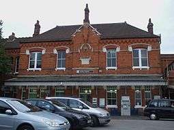
The town is on the main London-to-Brighton railway line and is served by Purley and Purley Oaks stations on that line, and Reedham station on the Tattenham Corner Line.
Nearest railway stations
Nearest places
See also
References
- ↑ "Promenade de Verdun history" (PDF). croydon.gov.uk. London Borough of Croydon. Retrieved 14 April 2018.
- ↑ "London Borough of Croydon : Purley Way and Valley Park". Croydon Online. 6 December 2007. Retrieved 12 June 2014.
- ↑ "Purley laughs all the way to the bank". The Daily Telegraph. London. 16 June 2002. Retrieved 12 November 2010.
- ↑ "58-12.co.uk". 58-12.co.uk. Retrieved 12 November 2010.
- ↑ http://www.ukcensusdata.com/purley-e05000159
- ↑ Granger, Derek (20 September 2000). "Obituaries: Shelagh Fraser". The Guardian. Archived from the original on 19 July 2018. Retrieved 19 July 2018.
- ↑ David Goodway, ‘Williamson, George Scott (1883–1953)’, Oxford Dictionary of National Biography, Oxford University Press, May 2012
External links
- Purley Business Association
- Purley Business Expo
- Purley Festival
- Local Gov. Site Promenade de Verdun
- History of Purley Village
- PWRA, Purley & Woodcote Residents' Association
- The Bourne Society, representing heritage interests in the debate over Purley regeneration
