Kvinnherad
| Kvinnherad kommune | |||
|---|---|---|---|
| Municipality | |||
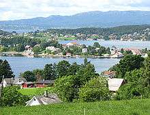
 View of the Husnes area | |||
| |||
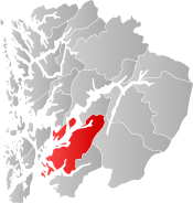 Kvinnherad within Hordaland | |||
| Coordinates: 59°55′41″N 06°02′13″E / 59.92806°N 6.03694°ECoordinates: 59°55′41″N 06°02′13″E / 59.92806°N 6.03694°E | |||
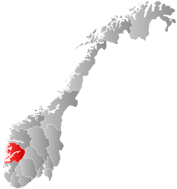
| Country | Norway | ||
| County | Hordaland | ||
| District | Sunnhordland | ||
| Administrative centre | Rosendal | ||
| Government | |||
| • Mayor (2015) | Peder Sjo Slettebø (H) | ||
| Area | |||
| • Total | 1,090.74 km2 (421.14 sq mi) | ||
| • Land | 1,042.65 km2 (402.57 sq mi) | ||
| • Water | 48.09 km2 (18.57 sq mi) | ||
| Area rank | #94 in Norway | ||
| Population (2017) | |||
| • Total | 13,241 | ||
| • Rank | #89 in Norway | ||
| • Density | 12.7/km2 (33/sq mi) | ||
| • Change (10 years) | 1.6% | ||
| Demonym(s) | Kvinnhering[1] | ||
| Time zone | UTC+01:00 (CET) | ||
| • Summer (DST) | UTC+02:00 (CEST) | ||
| ISO 3166 code | NO-1224 | ||
| Official language form | Nynorsk | ||
| Website |
www | ||

Kvinnherad is a municipality in Hordaland county, Norway. It is located in the traditional district of Sunnhordland, along the Hardangerfjorden. The municipality is the 5th in size in Hordaland county.[2]
The administrative centre of the municipality is the village of Rosendal. The largest village is Husnes, with about 6,000 people living in or near the village. Other villages include Ænes, Åkra, Dimmelsvik, Eidsvik, Hatlestrand, Herøysund, Høylandsbygd, Ølve, Sæbøvik, Sundal, Sunde, Uskedal, and Valen.
The 1,091-square-kilometre (421 sq mi) municipality is the 94th largest by area out of the 422 municipalities in Norway. Kvinnherad is the 89th most populous municipality in Norway with a population of 13,241. The municipality's population density is 12.7 inhabitants per square kilometre (33/sq mi) and its population has increased by 1.6% over the last decade.[3]
In the southern part of Kvinnherad you will find the typical fjord landscape of western Norway. The areas of Mauranger and Rosendal are said to have about the most beautiful fjord landscape of Hardanger as a whole: narrow fjords, wild water-falls, and the nearby Folgefonna, the third biggest glacier in Norway.[2]
General information


The parish of Qvindherred was established as a municipality on 1 January 1838 (see formannskapsdistrikt). On 1 January 1907, a small area northwest of the villages of Ølve and Husa (population: 67) was transferred from neighboring Tysnes municipality to Kvinnherad. During the 1960s, there were many municipal mergers across Norway due to the work of the Schei Committee. On 1 January 1965, the following areas were merged into one large municipality of Kvinnherad:[4]
- All of Skånevik municipality located north of the Skånevikfjorden-Åkrafjorden and west of the Åkra area (population: 1,189)
- All of Fjelberg municipality (population: 2,308)
- All of the old Kvinnherad municipality (population: 5,831)
- All of Varaldsøy municipality, except for the Mundheim area, (population: 511)
On 1 January 2013, the southwestern part of the Folgefonna peninsula (south of Kysnesstranda) was transferred from Kvinnherad to the neighboring Jondal municipality. This removed forty residents and 37.1 square kilometres (14.3 sq mi) of land area from the municipality.[5]
Name
The Old Norse form of the name was Kvinnaherað. The first element may be derived from the word tvinnr which means "double" (referring to the two rivers running through Rosendal, the administrative centre of the municipality). The last element is herað which means "district" or "municipality". The municipality name has been spelled several ways throughout history. Before 1889, the name was written "Quindherred", then from 1889-1917 it was "Kvinnherred", and since 1918 it has been spelled "Kvinnherad".[6]
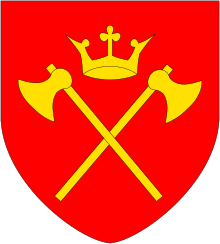
Coat-of-arms
The coat-of-arms is from modern times; they were granted on 18 June 1982. The arms show the confluence of two blue rivers into one on a white or silver background. The rivers symbolize the many streams and rivers in the municipality, especially the Hattebergselvi and the Melselvi, that come together just before they run into the sea at Rosendal.[7]
Churches
The Church of Norway has nine parishes (sokn) within the municipality of Kvinnherad. It is part of the Sunnhordland deanery in the Diocese of Bjørgvin.
| Parish (Sokn) | Church Name | Location of the Church | Year Built |
|---|---|---|---|
| Fjelberg og Eid | Eid Church | Eidsvik | 1824 |
| Fjelberg Church | Fjelbergøya | 1722 | |
| Hatlestrand | Hatlestrand Church | Hatlestrand | 1885 |
| Husnes og Holmedal | Holmedal Church | Utåker | 1815 |
| Husnes Church | Husnes | 1874 | |
| Valen Church | Valen | 1978 | |
| Kvinnherad | Kvinnherad Church | Rosendal | c. 1250 |
| Uskedalen | Uskedalen Church | Uskedal | 1914 |
| Varaldsøy | Varaldsøy Church | Varaldsøy | 1885 |
| Ænes | Ænes Church | Ænes | c. 1200 |
| Ølve | Ølve Church | Ølve | 1861 |
| Åkra | Åkra Church | Åkra | 1735 |
Economy
The economy of Kvinnherad is based on the rich water resources within its boundaries. This includes power production, aluminium production (Sør-Norge Aluminium), fish farming, shipbuilding (Eidsvik Skipsbyggeri, Hellesøy Verft, Bergen Group Halsnøy), and lifeboat production (Umoe Schat-Harding, Norsafe, Eide Marine Tech, Noreq). These industries are spread throughout the municipality.
Kvinnherad has two local newspapers, Kvinnheringen and Grenda, as well as a local TV channel, TV Sydvest.
| Historical population | ||
|---|---|---|
| Year | Pop. | ±% |
| 1951 | 5,638 | — |
| 1960 | 5,514 | −2.2% |
| 1970 | 11,811 | +114.2% |
| 1980 | 12,821 | +8.6% |
| 1990 | 13,121 | +2.3% |
| 2000 | 13,196 | +0.6% |
| 2010 | 13,187 | −0.1% |
| 2015 | 13,234 | +0.4% |
| Source: Statistics Norway. | ||
Government
All municipalities in Norway, including Kvinnherad, are responsible for primary education (through 10th grade), outpatient health services, senior citizen services, unemployment and other social services, zoning, economic development, and municipal roads. The municipality is governed by a municipal council of elected representatives, which in turn elect a mayor.
Municipal council
The municipal council (Kommunestyre) of Kvinnherad is made up of 35 representatives that are elected to four year terms. Currently, the party breakdown is as follows:[8]
| Party Name | Name in Norwegian | Number of representatives | |
|---|---|---|---|
| Labour Party | Arbeiderpartiet | 8 | |
| Progress Party | Framstegspartiet | 3 | |
| Conservative Party | Høgre | 12 | |
| Christian Democratic Party | Kristelig Folkeparti | 2 | |
| Green Party | Miljøpartiet Dei Grøne | 1 | |
| Centre Party | Senterpartiet | 6 | |
| Liberal Party | Venstre | 1 | |
| Local Lists | Lokale lister | 2 | |
| Total number of members: | 35 | ||
Geography
The municipality is located along the large Hardangerfjorden, mostly on the southeast side of the fjord on the Folgefonna peninsula, but also a small part on the other side. It includes several notable islands in the fjord including Varaldsøy, Fjelbergøya, Borgundøya, and Halsnøya.[2]
The large Folgefonna National Park, which surrounds the Folgefonna glacier, is partially located in Kvinnherad. The northern part of the municipality is often referred to as Mauranger. It is the area surrounding the Maurangsfjorden. The notable Bondhusbreen glacier is located just south of that fjord, near the village of Sundal. The Jondal Tunnel and Folgefonna Tunnel both connect Mauranger with neighboring Odda and Jondal by cutting through the large mountains surrounding Mauranger.[2]
The municipality has many large lakes including Blådalsvatnet, Juklavatnet, and Onarheimsvatnet. Many of these lakes are utilized for hydroelectric power generation.
Tourism and places of interest
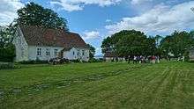
Kvinnherad is a popular tourist location because of its natural landscape as well as several places of interest. The most notable of which include Kvinnherad Church, the Bondhusbreen glacier, the shipping mural in Høylandsbygd, and Radiohola. Rosendal, the administrative centre of the municipality, is the site of the greatest tourist attraction in Kvinnherad: the Barony Rosendal. The Barony is the only one of its kind in Norway. It is a museum, which offers valuable information about the Union with Denmark, an important period of Norwegian history.[2]
Media gallery
 Kvinnherad Church in Rosendal
 The Barony Rosendal
- Husnes and the Hardangerfjord
 Bondhusbreen glacier
References
- ↑ "Navn på steder og personer: Innbyggjarnamn" (in Norwegian). Språkrådet. Retrieved 2015-12-01.
- 1 2 3 4 5 Store norske leksikon. "Kvinnherad" (in Norwegian). Retrieved 2015-03-30.
- ↑ Statistisk sentralbyrå (2017). "Table: 06913: Population 1 January and population changes during the calendar year (M)" (in Norwegian). Retrieved 2017-10-28.
- ↑ Jukvam, Dag (1999). "Historisk oversikt over endringer i kommune- og fylkesinndelingen" (PDF) (in Norwegian). Statistisk sentralbyrå.
- ↑ Olsen, Kjartan Wang (2011-12-08). "Jondal overtar Kvinnherad-bygder" (in Norwegian). Hardanger folkeblad. Retrieved 2014-06-21.
- ↑ Rygh, Oluf (1910). Norske gaardnavne: Søndre Bergenhus amt (in Norwegian) (11 ed.). Kristiania, Norge: W. C. Fabritius & sønners bogtrikkeri. p. 16.
- ↑ "Civic heraldry of Norway - Norske Kommunevåpen". Heraldry of the World. Retrieved 2015-03-30.
- ↑ "Table: 04813: Members of the local councils, by party/electoral list at the Municipal Council election (M)" (in Norwegian). Statistics Norway. 2015.
External links
- Municipal fact sheet from Statistics Norway (in Norwegian)
- http://www.kvinnherad.kommune.no (in Norwegian)
- http://www.baroniet.uio.no (in Norwegian)
- Kvinnheradguiden.no (in Norwegian)
- Kvinnheringen.no (in Norwegian)
- Grenda.no (in Norwegian)
- Innsida.no (in Norwegian)
- Husnes Ungdomsskule (in Norwegian)