Varaldsøy
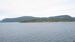 Varaldsøy seen from the south | |
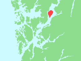 Location in Hordaland county | |
| Geography | |
|---|---|
| Location | Hordaland, Norway |
| Coordinates | 60°07′44″N 5°59′21″E / 60.1288°N 5.9893°ECoordinates: 60°07′44″N 5°59′21″E / 60.1288°N 5.9893°E |
| Area | 45.4 km2 (17.5 sq mi) |
| Highest elevation | 600 m (2,000 ft) |
| Highest point | Øyefjellet |
| Administration | |
|
Norway | |
| County | Hordaland |
| Municipalities | Kvinnherad |
Varaldsøy is an island (and village) in the municipality of Kvinnherad in Hordaland county, Norway. The 45.4-square-kilometre (17.5 sq mi) island is the largest island in the Hardangerfjorden. Most of the inhabitants live on the southern tip of the island in the village of Varaldsøy, where Varaldsøy Church is located. The 600-metre (2,000 ft) tall mountain Øyefjellet is the highest point on the island.[1]
History
The island was historically a part of Strandebarm municipality until 1902 when it was transferred to the new Varaldsøy Municipality. The island made up the majority of the municipality (plus some of the mainland to the west and north). In 1965, the municipality of Varaldsøy was dissolved in a period of municipal consolidations in Norway. The island was then transferred to the municipality of Kvinnherad.[2]
References
- ↑ Store norske leksikon. "Varaldsøy. – øy" (in Norwegian). Retrieved 2014-06-24.
- ↑ Jukvam, Dag (1999). "Historisk oversikt over endringer i kommune- og fylkesinndelingen" (PDF) (in Norwegian). Statistisk sentralbyrå.