Øygarden
| Øygarden kommune | |||
|---|---|---|---|
| Municipality | |||
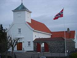 View of the local Blomvåg Church | |||
| |||
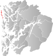 Øygarden within Hordaland | |||
| Coordinates: 60°36′39″N 04°49′29″E / 60.61083°N 4.82472°ECoordinates: 60°36′39″N 04°49′29″E / 60.61083°N 4.82472°E | |||
| Country | Norway | ||
| County | Hordaland | ||
| District | Midhordland | ||
| Administrative centre | Rong | ||
| Government | |||
| • Mayor (2015) | Børge Haugetun (Local list) | ||
| Area | |||
| • Total | 66.80 km2 (25.79 sq mi) | ||
| • Land | 64.44 km2 (24.88 sq mi) | ||
| • Water | 2.36 km2 (0.91 sq mi) | ||
| Area rank | #403 in Norway | ||
| Population (2017) | |||
| • Total | 4,913 | ||
| • Rank | #205 in Norway | ||
| • Density | 76.2/km2 (197/sq mi) | ||
| • Change (10 years) | 18.8% | ||
| Demonym(s) | Øygarding[1] | ||
| Time zone | UTC+01:00 (CET) | ||
| • Summer (DST) | UTC+02:00 (CEST) | ||
| ISO 3166 code | NO-1259 | ||
| Official language form | Nynorsk | ||
| Website |
www | ||

Øygarden(Norwegian pronunciation: [ˈøygɑːɽ̍en̩]) is a municipality in Hordaland county, Norway. It is an island municipality located in the traditional district of Midhordland. Since 2009, the administrative centre of Øygarden has been the village of Rong (before 2009, the village of Tjeldstø was the administrative centre). Other villages in the municipality include Alveim, Blomvåg, and Vikavågen.
The municipality consists of a chain of islands north of the municipality Fjell and northwest of the city of Bergen. Øygarden is connected to the mainland by a series of bridges and a single road running across the islands.
The 67-square-kilometre (26 sq mi) municipality is the 403rd largest by area out of the 422 municipalities in Norway. Øygarden is the 205th most populous municipality in Norway with a population of 4,913. The municipality's population density is 76.2 inhabitants per square kilometre (197/sq mi) and its population has increased by 18.8% over the last decade.[2]
General information

The municipality of Øygarden was established on 1 January 1964. It was created by a merger that was set in motion by the Schei Committee. The newly created Øygarden was made up of all of the old municipality of Hjelme (population: 956) and almost all of the municipality of Herdla (population: 2131) that was located west of the Hjeltefjorden (except for the islands of Turøy and Misje which went to the neighboring municipality of Fjell).[3]
On 1 January 2020, the three neighboring municipalities of Fjell, Sund, and Øygarden will be merging into one large island municipality called Øygarden.[4]
Name
The name was created in 1964 for the new municipality. The name is the finite form of øygard which means "row (fence) of islands". The first element is øy means "island" and the last element is gard which means "farm".[5]
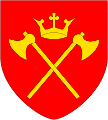
Coat-of-arms
The coat-of-arms is from modern times; they were granted in 1966, shortly after the establishment of the municipality. The arms show a black and gray reference seacairn sitting on an islet on a blue background. The municipality consists of a number of islands and is dependent on the sea for its development. Hence the importance of sea cairns, buoys and lighthouses for safety in the municipality.[6]
Churches
The Church of Norway has two parishes (sokn) within the municipality of Øygarden. It is part of the Vesthordland deanery in the Diocese of Bjørgvin.
| Parish (Sokn) | Church Name | Location of the Church | Year Built |
|---|---|---|---|
| Blomvåg | Blomvåg Church | Blomvåg | 1931 |
| Hjelme | Hjelme Church | Seløyna | 1971 |
| Old Hjelme Church | Seløyna | 1875 |
Geography
The municipality is made up of many islands. The vast majority of the residents live on the 6 largest islands. They are (from north to south): Seløyna (7.2 km2 [2.8 sq mi]), Alvøyna (12.2 km2 [4.7 sq mi]), Ona (6.8 km2 [2.6 sq mi]), Blomøyna (9.1 km2 [3.5 sq mi]), Rongøyna (2.7 km2 [1.0 sq mi]), and Toftøyna (7.5 km2 [2.9 sq mi]). Besides these large islands, the municipality consists of 546 small islands, islets, and reefs. Some of the other islands include Hernar in the far north and Førehjelmo.[5]
The landscape is low and relatively flat. The highest point is at only 74 metres (243 ft) on the island of Blomøyna. Several smaller lakes are located on the islands. The west side of the islands is an important nesting site for birds. The North Sea lies to the west of the islands and the Hjeltefjorden.[5]
Tjeldstø Marka on Alvøyna has been a protected nature reserve since 1995. It is one of the largest wetland reserves in Hordaland. The Ormhilleren friluftsområde is another nature reserve surrounding the Rongesundet strait.[7]
Government
| Historical population | ||
|---|---|---|
| Year | Pop. | ±% |
| 1951 | 1,050 | — |
| 1960 | 1,057 | +0.7% |
| 1970 | 2,835 | +168.2% |
| 1980 | 2,534 | −10.6% |
| 1990 | 3,158 | +24.6% |
| 2000 | 3,623 | +14.7% |
| 2010 | 4,267 | +17.8% |
| 2017 | 4,913 | +15.1% |
| Source: Statistics Norway. | ||
All municipalities in Norway, including Øygarden, are responsible for primary education (through 10th grade), outpatient health services, senior citizen services, unemployment and other social services, zoning, economic development, and municipal roads. The municipality is governed by a municipal council of elected representatives, which in turn elect a mayor.
Municipal council
The municipal council (Kommunestyre) of Øygarden is made up of 23 representatives that are elected to four year terms. Currently, the party breakdown is as follows:[8]
| Party Name | Name in Norwegian | Number of representatives | |
|---|---|---|---|
| Labour Party | Arbeiderpartiet | 6 | |
| Progress Party | Framstegspartiet | 2 | |
| Conservative Party | Høgre | 3 | |
| Christian Democratic Party | Kristelig Folkeparti | 2 | |
| Socialist Left Party | Sosialistisk Venstreparti | 1 | |
| Local Lists | Lokale lister | 9 | |
| Total number of members: | 23 | ||
Economy
The municipality has a significant aquaculture industry, primarily with salmon, cod, and shellfish. Agriculture is limited in the municipality and is largely a part-time occupation, with most farmers have another profession too. The type of agriculture in Øygarden is dominated by raising livestock (sheep, cattle, and chickens).[5]
Since 1988, petroleum activities have become a major industry in Øygarden. The transportation of oil from the Oseberg oil field through a pipeline to Sture on Alvøyna was the start of the oil boom. In 1996, a natural gas processing plant at Kollsnes on the island of Ona was completed.
Notable residents
- Martin Hjelmen (1904–1944), a Norwegian sailor and communist activist[9]
- Alexander Dale Oen (1985–2012), a competitive swimmer on the Norwegian national team
References
- ↑ "Navn på steder og personer: Innbyggjarnamn" (in Norwegian). Språkrådet. Retrieved 2015-12-01.
- ↑ Statistisk sentralbyrå (2017). "Table: 06913: Population 1 January and population changes during the calendar year (M)" (in Norwegian). Retrieved 2017-10-28.
- ↑ Jukvam, Dag (1999). "Historisk oversikt over endringer i kommune- og fylkesinndelingen" (PDF) (in Norwegian). Statistisk sentralbyrå.
- ↑ "Vår nye kommune" (in Norwegian). Retrieved 2017-10-28.
- 1 2 3 4 Store norske leksikon. "Øygarden" (in Norwegian). Retrieved 2014-11-28.
- ↑ "Civic heraldry of Norway - Norske Kommunevåpen". Heraldry of the World. Retrieved 2014-11-28.
- ↑ En liten perle i Øygarden [A small pearl in Øygarden]
- ↑ "Table: 04813: Members of the local councils, by party/electoral list at the Municipal Council election (M)" (in Norwegian). Statistics Norway. 2015.
- ↑ Uklart om likvidasjoner
External links
| Wikimedia Commons has media related to Øygarden. |
- Municipal fact sheet from Statistics Norway (in Norwegian)